
WW 269 TORNADO CO KS NE 202210Z – 210500Z
URGENT – IMMEDIATE BROADCAST REQUESTED
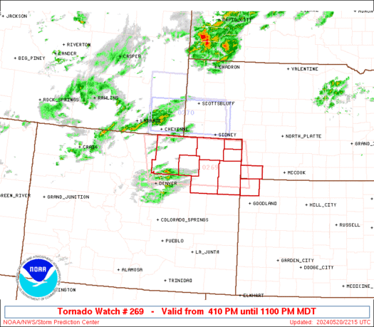
Tornado Watch Number 269
NWS Storm Prediction Center Norman OK
410 PM MDT Mon May 20 2024
The NWS Storm Prediction Center has issued a
* Tornado Watch for portions of
Northeast Colorado
Extreme northwest Kansas
Extreme southwest Nebraska
* Effective this Monday afternoon and evening from 410 PM until
1100 PM MDT.
* Primary threats include…
A couple tornadoes possible
Scattered large hail and isolated very large hail events to 2.5
inches in diameter likely
Scattered damaging wind gusts to 70 mph possible
SUMMARY…A few supercells are expected to form this evening across
northeast CO, and the storms will then move east-northeastward
toward extreme southwest Nebraska and northwest Kansas through late
evening/early tonight. Very large hail to 2.5 inches in diameter
and severe gusts of 60-70 mph will be the main threats, though a
gradual increase in low-level moisture later this evening will
support the potential for a couple of tornadoes.
The tornado watch area is approximately along and 90 statute miles
east and west of a line from 60 miles north northwest of Akron CO to
30 miles south southwest of Akron CO. For a complete depiction of
the watch see the associated watch outline update (WOUS64 KWNS
WOU9).
PRECAUTIONARY/PREPAREDNESS ACTIONS…
REMEMBER…A Tornado Watch means conditions are favorable for
tornadoes and severe thunderstorms in and close to the watch
area. Persons in these areas should be on the lookout for
threatening weather conditions and listen for later statements
and possible warnings.
&&
OTHER WATCH INFORMATION…CONTINUE…WW 268…
AVIATION…Tornadoes and a few severe thunderstorms with hail
surface and aloft to 2.5 inches. Extreme turbulence and surface wind
gusts to 60 knots. A few cumulonimbi with maximum tops to 450. Mean
storm motion vector 26025.
…Thompson