
WW 324 TORNADO IL IN KY 262350Z – 270600Z
URGENT – IMMEDIATE BROADCAST REQUESTED
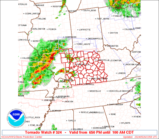
Tornado Watch Number 324
NWS Storm Prediction Center Norman OK
650 PM CDT Sun May 26 2024
The NWS Storm Prediction Center has issued a
* Tornado Watch for portions of
Southeast Illinois
Southern Indiana
Western and Central Kentucky
* Effective this Sunday night and Monday morning from 650 PM
until 100 AM CDT.
* Primary threats include…
Several tornadoes and a couple intense tornadoes likely
Widespread damaging winds and isolated significant gusts to 85
mph likely
Scattered large hail and isolated very large hail events to 3
inches in diameter likely
SUMMARY…Scattered supercells are forecast to move into the lower
Ohio Valley early this evening and pose a risk for tornadoes, some
potentially strong, and large to very large hail (up 2 to 3 inches
in diameter). Severe gusts are forecast to become more prevalent
later this evening as a severe squall line with embedded supercells
or mesovortices moves across the Watch area. A tornado risk will
probably accompany any stronger line-embedded circulations.
The tornado watch area is approximately along and 90 statute miles
east and west of a line from 70 miles north northeast of Evansville
IN to 30 miles south southwest of Bowling Green KY. For a complete
depiction of the watch see the associated watch outline update
(WOUS64 KWNS WOU4).
PRECAUTIONARY/PREPAREDNESS ACTIONS…
REMEMBER…A Tornado Watch means conditions are favorable for
tornadoes and severe thunderstorms in and close to the watch
area. Persons in these areas should be on the lookout for
threatening weather conditions and listen for later statements
and possible warnings.
&&
OTHER WATCH INFORMATION…CONTINUE…WW 316…WW 317…WW
318…WW 319…WW 320…WW 321…WW 322…WW 323…
AVIATION…Tornadoes and a few severe thunderstorms with hail
surface and aloft to 3 inches. Extreme turbulence and surface wind
gusts to 75 knots. A few cumulonimbi with maximum tops to 550. Mean
storm motion vector 24035.
…Smith