
WW 58 TORNADO FL CW 230005Z – 230700Z
URGENT – IMMEDIATE BROADCAST REQUESTED
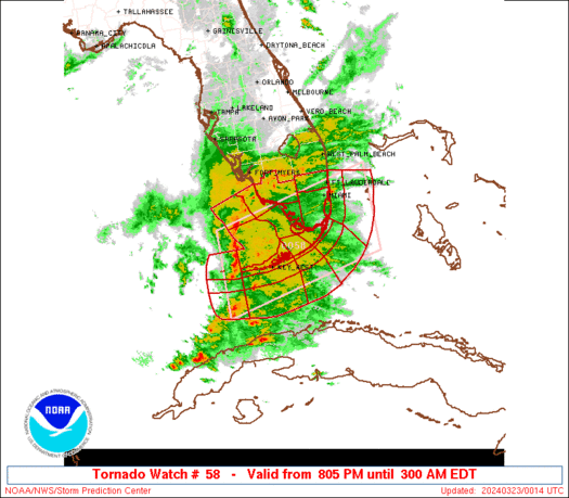
Tornado Watch Number 58
NWS Storm Prediction Center Norman OK
805 PM EDT Fri Mar 22 2024
The NWS Storm Prediction Center has issued a
* Tornado Watch for portions of
Southern Florida
Coastal Waters
* Effective this Friday night and Saturday morning from 805 PM
until 300 AM EDT.
* Primary threats include…
A couple tornadoes possible
Scattered damaging wind gusts to 70 mph possible
SUMMARY…A linear cluster of storms, along with some line-preceding
supercells, will initially approach the Florida Keys, and eventually
the far southern Florida Peninsula later this evening. Within a
favorably moist environment amid strong deep-layer winds, these
storms will pose a waterspout/tornado risk aside from wind damage.
The tornado watch area is approximately along and 65 statute miles
north and south of a line from 70 miles west of Key West FL to 70
miles east southeast of Miami FL. For a complete depiction of the
watch see the associated watch outline update (WOUS64 KWNS WOU8).
PRECAUTIONARY/PREPAREDNESS ACTIONS…
REMEMBER…A Tornado Watch means conditions are favorable for
tornadoes and severe thunderstorms in and close to the watch
area. Persons in these areas should be on the lookout for
threatening weather conditions and listen for later statements
and possible warnings.
&&
AVIATION…Tornadoes and a few severe thunderstorms with hail
surface and aloft to 1 inch. Extreme turbulence and surface wind
gusts to 60 knots. A few cumulonimbi with maximum tops to 500. Mean
storm motion vector 27035.
…Guyer