
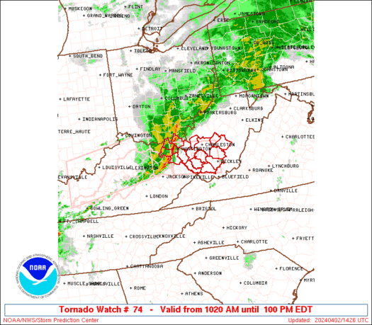
WW 74 TORNADO KY OH WV 021420Z – 021700Z
URGENT – IMMEDIATE BROADCAST REQUESTED
Tornado Watch Number 74
NWS Storm Prediction Center Norman OK
1020 AM EDT Tue Apr 2 2024
The NWS Storm Prediction Center has issued a
* Tornado Watch for portions of
Extreme northeast Kentucky
Extreme southern Ohio
Southern West Virginia
* Effective this Tuesday morning and afternoon from 1020 AM until
100 PM EDT.
* Primary threats include…
A couple tornadoes possible
Scattered damaging wind gusts to 70 mph likely
Isolated large hail events to 1 inch in diameter possible
SUMMARY…A well-developed squall line may persist for a few more
hours as it moves from Kentucky into West Virginia this morning.
Damaging gusts of 60-70 mph and a couple of tornadoes with embedded
circulations will be possible.
The tornado watch area is approximately along and 35 statute miles
north and south of a line from 25 miles southwest of Huntington WV
to 10 miles north northeast of Beckley WV. For a complete depiction
of the watch see the associated watch outline update (WOUS64 KWNS
WOU4).
PRECAUTIONARY/PREPAREDNESS ACTIONS…
REMEMBER…A Tornado Watch means conditions are favorable for
tornadoes and severe thunderstorms in and close to the watch
area. Persons in these areas should be on the lookout for
threatening weather conditions and listen for later statements
and possible warnings.
&&
OTHER WATCH INFORMATION…CONTINUE…WW 73…
AVIATION…Tornadoes and a few severe thunderstorms with hail
surface and aloft to 1 inch. Extreme turbulence and surface wind
gusts to 60 knots. A few cumulonimbi with maximum tops to 450. Mean
storm motion vector 28050.
…Thompson