

MD 0520 CONCERNING SEVERE THUNDERSTORM WATCH 136… FOR SOUTH-CENTRAL NEBRASKA INTO ADJACENT NORTH-CENTRAL KANSAS Mesoscale Discussion 0520 NWS Storm Prediction Center Norman OK 1206 AM CDT Fri Apr 26 2024 Areas affected…south-central Nebraska into adjacent north-central Kansas Concerning…Severe Thunderstorm Watch 136… Valid 260506Z – 260600Z The severe weather threat for Severe Thunderstorm Watch 136 continues. …
Continue reading SPC MD 520
Month:April 2024
SPC Severe Thunderstorm Watch 136 Status Reports
WW 0136 Status Updates STATUS REPORT ON WW 136 SEVERE WEATHER THREAT CONTINUES RIGHT OF A LINE FROM 15 NE HLC TO 35 NNE HLC TO 10 WSW MCK TO 25 ENE IML. ..GOSS..04/26/24 ATTN…WFO…GLD…GID…LBF… STATUS REPORT FOR WS 136 SEVERE WEATHER THREAT CONTINUES FOR THE FOLLOWING AREAS KSC089-147-183-260540- KS . KANSAS COUNTIES INCLUDED ARE …
Continue reading SPC Severe Thunderstorm Watch 136 Status Reports
SPC MD 518
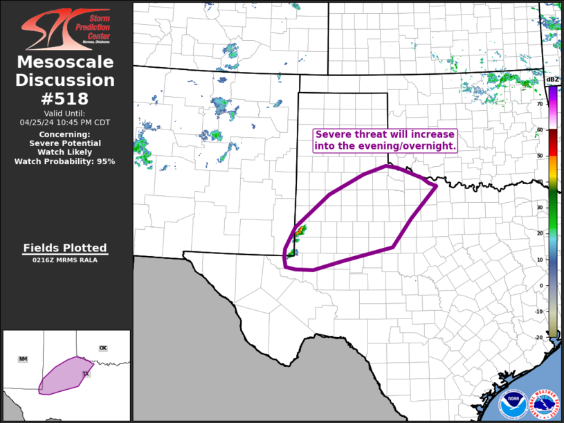
MD 0518 CONCERNING SEVERE POTENTIAL…WATCH LIKELY FOR PORTIONS OF WEST AND NORTHWEST TEXAS Mesoscale Discussion 0518 NWS Storm Prediction Center Norman OK 0919 PM CDT Thu Apr 25 2024 Areas affected…portions of west and northwest Texas Concerning…Severe potential…Watch likely Valid 260219Z – 260345Z Probability of Watch Issuance…95 percent SUMMARY…Severe threat is increasing through the evening/overnight. …
Continue reading SPC MD 518
SPC MD 519
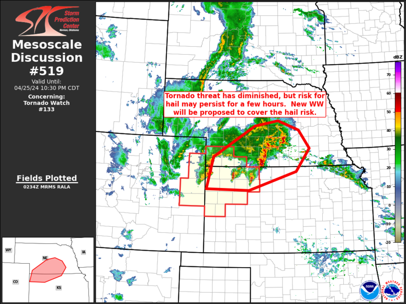
MD 0519 CONCERNING TORNADO WATCH 133… FOR NORTHERN KANSAS/SOUTHERN NEBRASKA Mesoscale Discussion 0519 NWS Storm Prediction Center Norman OK 0935 PM CDT Thu Apr 25 2024 Areas affected…northern Kansas/southern Nebraska Concerning…Tornado Watch 133… Valid 260235Z – 260330Z The severe weather threat for Tornado Watch 133 continues. SUMMARY…Tornado risk has diminished, but hail risk will continue …
Continue reading SPC MD 519
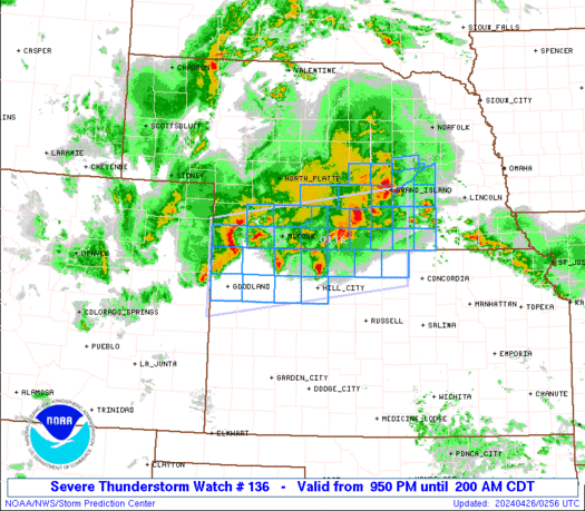
SPC Severe Thunderstorm Watch 136
WW 136 SEVERE TSTM KS NE 260250Z – 260700Z URGENT – IMMEDIATE BROADCAST REQUESTED Severe Thunderstorm Watch Number 136 NWS Storm Prediction Center Norman OK 950 PM CDT Thu Apr 25 2024 The NWS Storm Prediction Center has issued a * Severe Thunderstorm Watch for portions of northwestern and north-central Kansas southwestern and south-central Nebraska …
Continue reading SPC Severe Thunderstorm Watch 136
SPC Severe Thunderstorm Watch 135
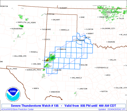
WW 135 SEVERE TSTM OK TX 260235Z – 260900Z URGENT – IMMEDIATE BROADCAST REQUESTED Severe Thunderstorm Watch Number 135 NWS Storm Prediction Center Norman OK 935 PM CDT Thu Apr 25 2024 The NWS Storm Prediction Center has issued a * Severe Thunderstorm Watch for portions of Southwestern Oklahoma West and northwest Texas * Effective …
Continue reading SPC Severe Thunderstorm Watch 135
SPC Tornado Watch 133 Status Reports

WW 0133 Status Updates STATUS REPORT ON WW 133 THE SEVERE WEATHER THREAT CONTINUES ACROSS THE ENTIRE WATCH AREA. ..GOSS..04/26/24 ATTN…WFO…GLD…BOU…LBF… STATUS REPORT FOR WT 133 SEVERE WEATHER THREAT CONTINUES FOR THE FOLLOWING AREAS COC017-063-075-095-115-121-125-260340- CO . COLORADO COUNTIES INCLUDED ARE CHEYENNE KIT CARSON LOGAN PHILLIPS SEDGWICK WASHINGTON YUMA KSC023-039-063-065-071-109-137-153-179-181-193-199-203-260340- KS . KANSAS COUNTIES INCLUDED …
Continue reading SPC Tornado Watch 133 Status Reports
SPC MD 516
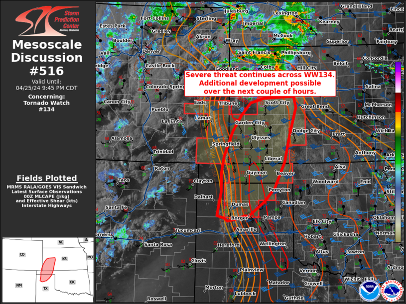
MD 0516 CONCERNING TORNADO WATCH 134… FOR NORTHERN TEXAS PANHANDLE…CENTRAL OKLAHOMA PANHANDLE…AND SOUTHWESTERN KANSAS Mesoscale Discussion 0516 NWS Storm Prediction Center Norman OK 0742 PM CDT Thu Apr 25 2024 Areas affected…northern Texas Panhandle…central Oklahoma Panhandle…and southwestern Kansas Concerning…Tornado Watch 134… Valid 260042Z – 260245Z The severe weather threat for Tornado Watch 134 continues. SUMMARY…Severe …
Continue reading SPC MD 516
SPC MD 517

MD 0517 CONCERNING TORNADO WATCH 133… FOR SOUTHWESTERN NEBRASKA…NORTHWESTERN KANSAS Mesoscale Discussion 0517 NWS Storm Prediction Center Norman OK 0748 PM CDT Thu Apr 25 2024 Areas affected…southwestern Nebraska…northwestern Kansas Concerning…Tornado Watch 133… Valid 260048Z – 260145Z The severe weather threat for Tornado Watch 133 continues. SUMMARY…Storms have diminished in coverage and intensity over the …
Continue reading SPC MD 517
SPC Tornado Watch 134 Status Reports
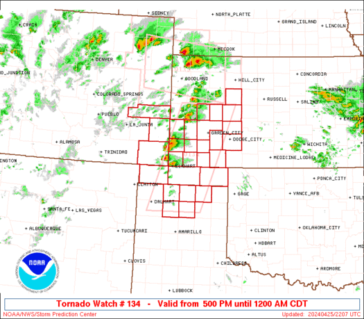
WW 0134 Status Updates STATUS REPORT ON WW 134 SEVERE WEATHER THREAT CONTINUES RIGHT OF A LINE FROM 20 SSW DHT TO 35 S GLD. FOR ADDITIONAL INFORMATION SEE MESOSCALE DISCUSSION 0134 ..THORNTON..04/26/24 ATTN…WFO…PUB…DDC…AMA… STATUS REPORT FOR WT 134 SEVERE WEATHER THREAT CONTINUES FOR THE FOLLOWING AREAS KSC055-057-067-069-075-081-083-093-101-119-129-135-171-175-187- 189-195-260140- KS . KANSAS COUNTIES INCLUDED ARE …
Continue reading SPC Tornado Watch 134 Status Reports