
WW 0201 Status Updates STATUS REPORT ON WW 201 SEVERE WEATHER THREAT CONTINUES RIGHT OF A LINE FROM 40 NNW DYR TO 25 ESE PAH TO 25 NE BWG. ..BROYLES..05/08/24 ATTN…WFO…PAH…LMK… STATUS REPORT FOR WT 201 SEVERE WEATHER THREAT CONTINUES FOR THE FOLLOWING AREAS KYC035-047-075-083-105-141-157-213-219-221-227-081040- KY . KENTUCKY COUNTIES INCLUDED ARE CALLOWAY CHRISTIAN FULTON GRAVES …
Continue reading SPC Tornado Watch 201 Status Reports
Month:May 2024
SPC MD 691

MD 0691 CONCERNING TORNADO WATCH 200… FOR ARKANSAS…FAR NORTHWEST MISSISSIPPI…FAR SOUTHWEST TENNESSEE Mesoscale Discussion 0691 NWS Storm Prediction Center Norman OK 0323 AM CDT Wed May 08 2024 Areas affected…Arkansas…Far Northwest Mississippi…Far Southwest Tennessee Concerning…Tornado Watch 200… Valid 080823Z – 081030Z The severe weather threat for Tornado Watch 200 continues. SUMMARY…A tornado and wind-damage threat …
Continue reading SPC MD 691
SPC MD 690
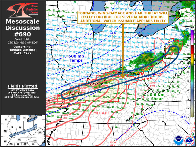
MD 0690 CONCERNING TORNADO WATCH 198…199… FOR OHIO VALLEY Mesoscale Discussion 0690 NWS Storm Prediction Center Norman OK 0126 AM CDT Wed May 08 2024 Areas affected…Ohio Valley Concerning…Tornado Watch 198…199… Valid 080626Z – 080830Z The severe weather threat for Tornado Watch 198, 199 continues. SUMMARY…A tornado, wind-damage and hail threat will likely continue for …
Continue reading SPC MD 690
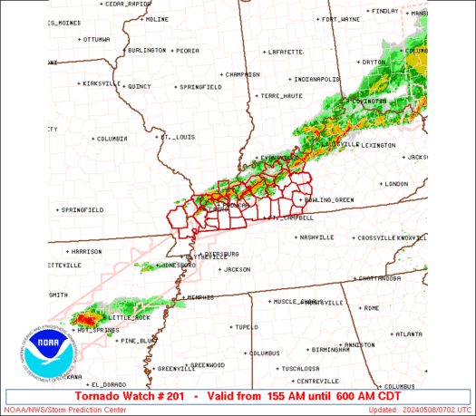
SPC Tornado Watch 201
WW 201 TORNADO IL KY MO 080655Z – 081100Z URGENT – IMMEDIATE BROADCAST REQUESTED Tornado Watch Number 201 NWS Storm Prediction Center Norman OK 155 AM CDT Wed May 8 2024 The NWS Storm Prediction Center has issued a * Tornado Watch for portions of Extreme southern Illinois Western and west-central Kentucky Extreme southeastern Missouri …
Continue reading SPC Tornado Watch 201
SPC Tornado Watch 198 Status Reports

WW 0198 Status Updates STATUS REPORT ON WW 198 SEVERE WEATHER THREAT CONTINUES RIGHT OF A LINE FROM 30 W CGI TO 30 SW EVV TO 10 WNW SDF TO 35 N LEX TO 40 SE LUK. ..BROYLES..05/08/24 ATTN…WFO…PAH…LMK…JKL… STATUS REPORT FOR WT 198 SEVERE WEATHER THREAT CONTINUES FOR THE FOLLOWING AREAS ILC003-069-087-127-151-153-080740- IL . …
Continue reading SPC Tornado Watch 198 Status Reports
SPC Tornado Watch 200
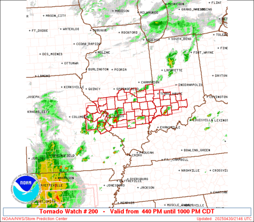
WW 200 TORNADO AR MO OK TN TX 080555Z – 081100Z URGENT – IMMEDIATE BROADCAST REQUESTED Tornado Watch Number 200 NWS Storm Prediction Center Norman OK 1255 AM CDT Wed May 8 2024 The NWS Storm Prediction Center has issued a * Tornado Watch for portions of Southwestern, central and northeastern Arkansas Missouri Bootheel Extreme …
Continue reading SPC Tornado Watch 200
SPC Tornado Watch 199 Status Reports
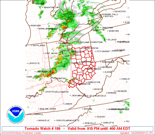
WW 0199 Status Updates STATUS REPORT ON WW 199 SEVERE WEATHER THREAT CONTINUES RIGHT OF A LINE FROM 35 S CMH TO 15 ENE CAK. ..SPC..05/08/24 ATTN…WFO…RLX…CLE…PBZ… STATUS REPORT FOR WT 199 SEVERE WEATHER THREAT CONTINUES FOR THE FOLLOWING AREAS KYC019-043-089-080540- KY . KENTUCKY COUNTIES INCLUDED ARE BOYD CARTER GREENUP OHC009-013-019-029-031-053-059-067-079-081-087-105-111-115-119- 121-127-151-157-163-167-080540- OH . OHIO …
Continue reading SPC Tornado Watch 199 Status Reports
SPC Tornado Watch 197 Status Reports
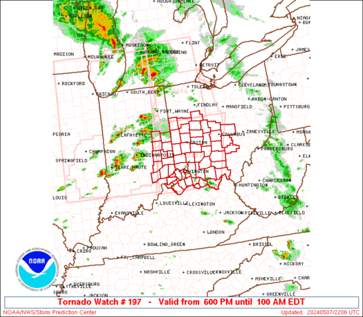
WW 0197 Status Updates STATUS REPORT ON WW 197 SEVERE WEATHER THREAT CONTINUES RIGHT OF A LINE FROM 50 ESE IND TO 35 WNW UNI. ..SPC..05/08/24 ATTN…WFO…ILN…IND… STATUS REPORT FOR WT 197 SEVERE WEATHER THREAT CONTINUES FOR THE FOLLOWING AREAS INC029-031-079-115-137-155-080540- IN . INDIANA COUNTIES INCLUDED ARE DEARBORN DECATUR JENNINGS OHIO RIPLEY SWITZERLAND KYC015-023-037-041-077-081-117-135-161-187-191-201-080540- KY …
Continue reading SPC Tornado Watch 197 Status Reports
SPC MD 689

MD 0689 CONCERNING TORNADO WATCH 197…198…199… FOR OHIO VALLEY Mesoscale Discussion 0689 NWS Storm Prediction Center Norman OK 1116 PM CDT Tue May 07 2024 Areas affected…Ohio Valley Concerning…Tornado Watch 197…198…199… Valid 080416Z – 080615Z The severe weather threat for Tornado Watch 197, 198, 199 continues. SUMMARY…Scattered severe thunderstorms will sag southeast across the Ohio …
Continue reading SPC MD 689
SPC Tornado Watch 196 Status Reports

WW 0196 Status Updates STATUS REPORT ON WW 196 SEVERE WEATHER THREAT CONTINUES RIGHT OF A LINE FROM 40 SE FWA TO 35 SW TOL TO 30 WNW TOL TO 15 ESE JXN TO 15 N DTW. ..SPC..05/08/24 ATTN…WFO…IWX…GRR…DTX…CLE… STATUS REPORT FOR WT 196 SEVERE WEATHER THREAT CONTINUES FOR THE FOLLOWING AREAS MIC091-115-161-080240- MI . …
Continue reading SPC Tornado Watch 196 Status Reports