

WW 0190 Status Updates STATUS REPORT ON WW 190 SEVERE WEATHER THREAT CONTINUES RIGHT OF A LINE FROM 40 NE ICT TO 20 W MHK TO 30 SE BIE TO 10 WSW SDA TO 25 NE SDA. ..WENDT..05/07/24 ATTN…WFO…OAX…TOP…EAX… STATUS REPORT FOR WT 190 SEVERE WEATHER THREAT CONTINUES FOR THE FOLLOWING AREAS IAC071-137-145-070440- IA . …
Continue reading SPC Tornado Watch 190 Status Reports
Month:May 2024
SPC Tornado Watch 193
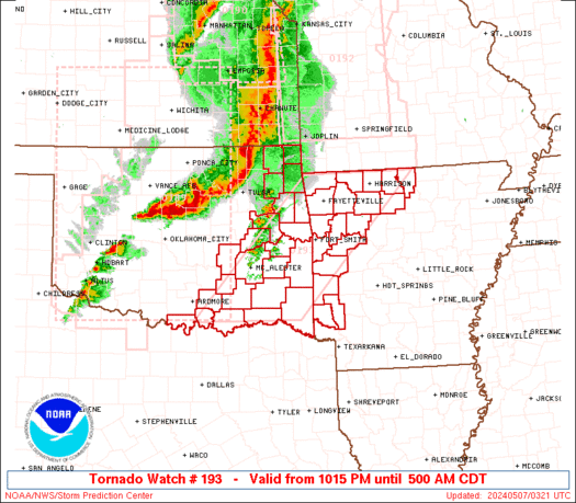
WW 193 TORNADO AR OK 070315Z – 071000Z URGENT – IMMEDIATE BROADCAST REQUESTED Tornado Watch Number 193 NWS Storm Prediction Center Norman OK 1015 PM CDT Mon May 6 2024 The NWS Storm Prediction Center has issued a * Tornado Watch for portions of Western and Northern Arkansas Eastern and Southern Oklahoma * Effective this …
Continue reading SPC Tornado Watch 193
SPC Tornado Watch 192

WW 192 TORNADO KS MO 070140Z – 070900Z URGENT – IMMEDIATE BROADCAST REQUESTED Tornado Watch Number 192 NWS Storm Prediction Center Norman OK 840 PM CDT Mon May 6 2024 The NWS Storm Prediction Center has issued a * Tornado Watch for portions of Far Eastern Kansas Western and Central Missouri * Effective this Monday …
Continue reading SPC Tornado Watch 192
SPC MD 664
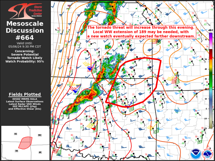
MD 0664 CONCERNING SEVERE POTENTIAL…TORNADO WATCH LIKELY FOR NORTHEAST OK INTO SOUTHEAST KS AND EXTREME SOUTHWEST MO Mesoscale Discussion 0664 NWS Storm Prediction Center Norman OK 0800 PM CDT Mon May 06 2024 Areas affected…Northeast OK into southeast KS and extreme southwest MO Concerning…Severe potential…Tornado Watch likely Valid 070100Z – 070230Z Probability of Watch Issuance…95 …
Continue reading SPC MD 664
SPC MD 665
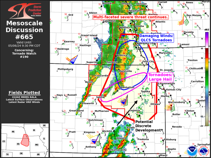
MD 0665 CONCERNING TORNADO WATCH 190… FOR NORTHEAST KANSAS INTO SOUTHEAST NEBRASKA Mesoscale Discussion 0665 NWS Storm Prediction Center Norman OK 0806 PM CDT Mon May 06 2024 Areas affected…Northeast Kansas into Southeast Nebraska Concerning…Tornado Watch 190… Valid 070106Z – 070230Z The severe weather threat for Tornado Watch 190 continues. SUMMARY…A multi-faceted severe threat continues …
Continue reading SPC MD 665
SPC Tornado Watch 191
WW 191 TORNADO IA NE SD 070030Z – 070800Z URGENT – IMMEDIATE BROADCAST REQUESTED Tornado Watch Number 191 NWS Storm Prediction Center Norman OK 730 PM CDT Mon May 6 2024 The NWS Storm Prediction Center has issued a * Tornado Watch for portions of Western and Central Iowa Northeast Nebraska Far Southeast South Dakota …
Continue reading SPC Tornado Watch 191
SPC MD 660
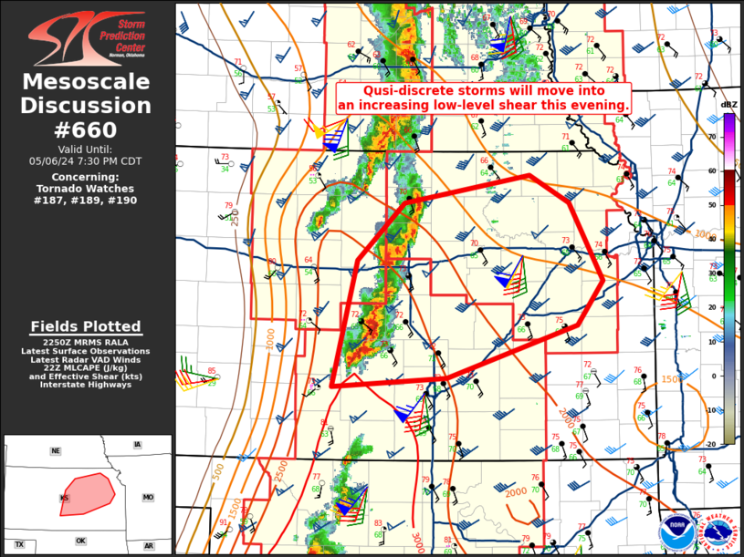
MD 0660 CONCERNING TORNADO WATCH 187…189…190… FOR CENTRAL INTO NORTHEAST KANSAS Mesoscale Discussion 0660 NWS Storm Prediction Center Norman OK 0553 PM CDT Mon May 06 2024 Areas affected…Central into northeast Kansas Concerning…Tornado Watch 187…189…190… Valid 062253Z – 070030Z The severe weather threat for Tornado Watch 187, 189, 190 continues. SUMMARY…An increase in the tornado …
Continue reading SPC MD 660
SPC MD 661
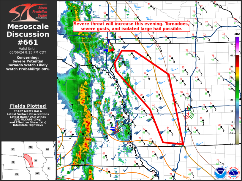
MD 0661 CONCERNING SEVERE POTENTIAL…TORNADO WATCH LIKELY FOR PORTIONS OF WESTERN/CENTRAL IOWA Mesoscale Discussion 0661 NWS Storm Prediction Center Norman OK 0618 PM CDT Mon May 06 2024 Areas affected…Portions of western/central Iowa Concerning…Severe potential…Tornado Watch likely Valid 062318Z – 070115Z Probability of Watch Issuance…80 percent SUMMARY…Storms will move east-northeast out of Nebraska into western …
Continue reading SPC MD 661
SPC Tornado Watch 187 Status Reports
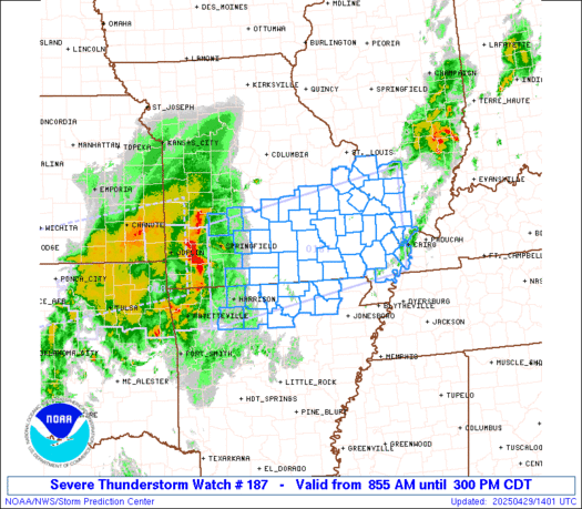
WW 0187 Status Updates STATUS REPORT ON WW 187 SEVERE WEATHER THREAT CONTINUES RIGHT OF A LINE FROM 35 S RSL TO 50 W CNK TO 25 ESE HSI TO 30 NNE GRI TO 20 E ANW TO 40 NNE ANW. ..LEITMAN..05/06/24 ATTN…WFO…ICT…DDC…GLD…GID…LBF… STATUS REPORT FOR WT 187 SEVERE WEATHER THREAT CONTINUES FOR THE FOLLOWING …
Continue reading SPC Tornado Watch 187 Status Reports
SPC Severe Thunderstorm Watch 188 Status Reports
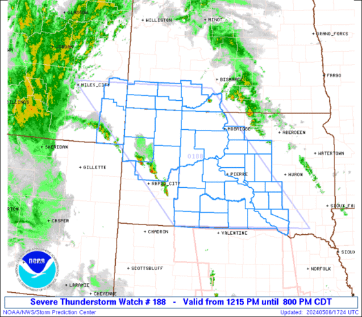
WW 0188 Status Updates STATUS REPORT ON WW 188 SEVERE WEATHER THREAT CONTINUES RIGHT OF A LINE FROM 40 NE ANW TO 15 W 9V9 TO 35 NNW PIR TO 40 W MBG TO 25 ESE BHK TO 35 W BHK. ..LEITMAN..05/06/24 ATTN…WFO…BYZ…BIS…FSD…UNR…ABR… STATUS REPORT FOR WS 188 SEVERE WEATHER THREAT CONTINUES FOR THE FOLLOWING …
Continue reading SPC Severe Thunderstorm Watch 188 Status Reports