
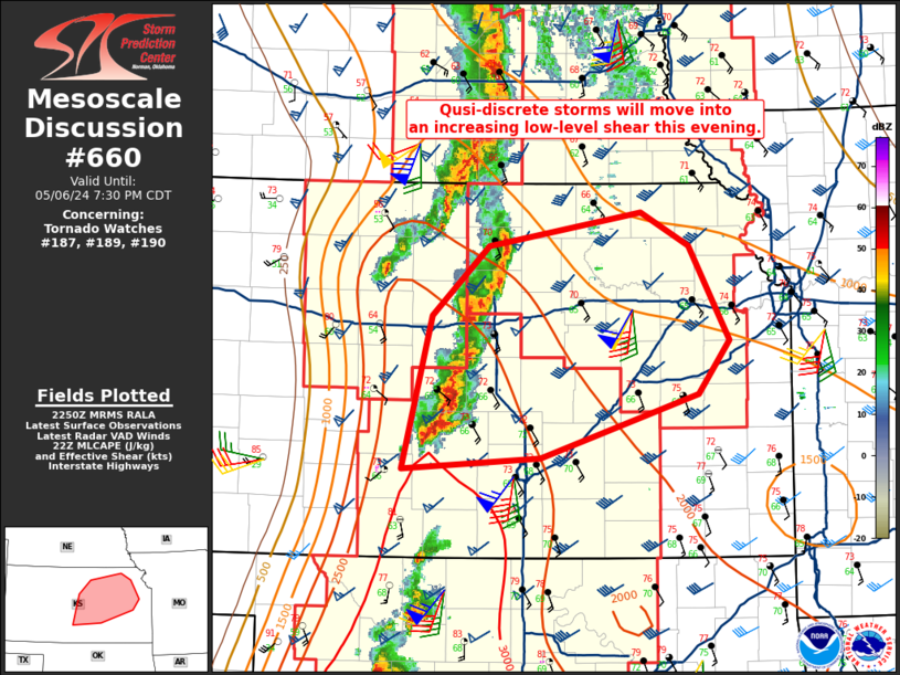
MD 0660 CONCERNING TORNADO WATCH 187…189…190… FOR CENTRAL INTO NORTHEAST KANSAS
Mesoscale Discussion 0660
NWS Storm Prediction Center Norman OK
0553 PM CDT Mon May 06 2024
Areas affected…Central into northeast Kansas
Concerning…Tornado Watch 187…189…190…
Valid 062253Z – 070030Z
The severe weather threat for Tornado Watch 187, 189, 190 continues.
SUMMARY…An increase in the tornado threat will likely occur as the
low-level jet increases in eastern Kansas this evening. The
magnitude of this threat will be conditional on maintaining at least
quasi-discrete storms. QLCS tornadoes will still be possible within
any linear segments.
DISCUSSION…Winds aloft have remained backed enough to keep storms
in central Kansas quasi-discrete. Very-large hail has been the
primary threat with these storms thus far (reports of 2.5-3 in.).
Regional VAD profiles show the low-level jet at 45-50 kts currently.
The jet should intensify this evening, especially within eastern
Kansas. The primary question is whether storms will remain discrete
beyond 00Z. Continued mid-level height falls this evening could be
enough to increase convective coverage such that a more linear mode
develops. The greatest threat for tornadoes, especially strong
tornadoes, will depend on maintaining discrete storms. Given the
strength of the low-level jet, it is possible that some discrete
storms could develop ahead of this line due to warm advection. Even
with a more linear mode, however, severe wind gusts and QLCS
tornadoes would still be possible.
..Wendt.. 05/06/2024
…Please see www.spc.noaa.gov for graphic product…
ATTN…WFO…TOP…ICT…GID…DDC…
LAT…LON 38939828 39499769 39779613 39509564 38749524 38309556
37799716 37709857 38939828