
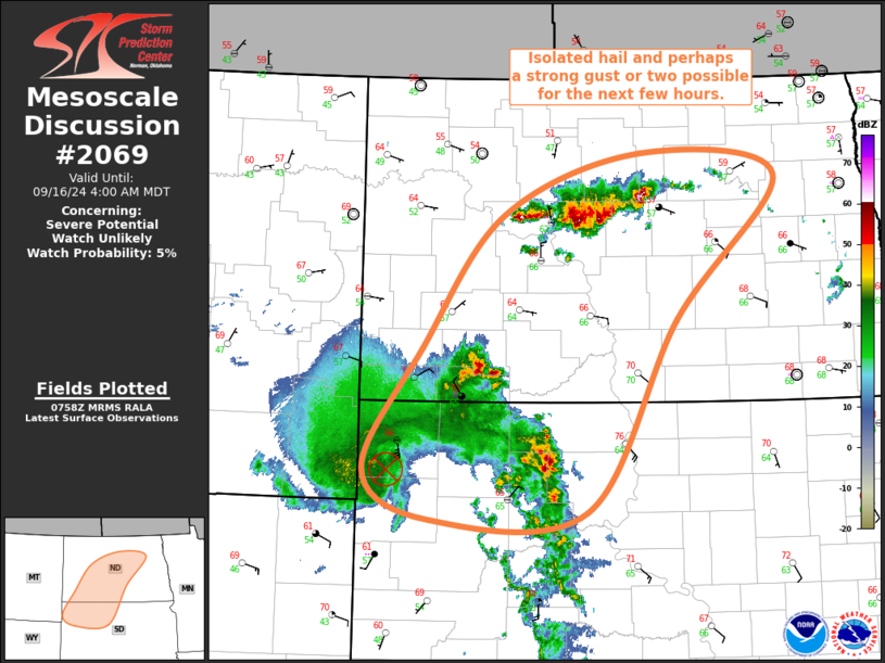
MD 2069 CONCERNING SEVERE POTENTIAL…WATCH POSSIBLE FOR PARTS OF WESTERN/CENTRAL SD INTO SOUTHWEST ND
Mesoscale Discussion 2069
NWS Storm Prediction Center Norman OK
0949 PM CDT Fri Sep 12 2025
Areas affected...Parts of western/central SD into southwest ND
Concerning...Severe potential...Watch possible
Valid 130249Z - 130445Z
Probability of Watch Issuance...40 percent
SUMMARY...A threat for isolated hail and strong to locally severe
gusts will continue into late tonight.
DISCUSSION...Earlier slow-moving supercells have largely weakened
across northwest SD/southwest ND, but recent vigorous development
has been noted across southwest SD along a northeastward-moving
outflow emanating out of the northern High Plains. Additional strong
to potentially severe storms may develop along this outflow as it
impinges upon a favorable thermodynamic environment (as observed in
the 00Z BIS/ABR soundings). While ascent along the outflow may
encourage some tendency toward development of clusters or small line
segments, favorable deep-layer shear combined with weak low-level
flow may continue to favor isolated or semi-discrete cells with a
continued threat of large hail. While MLCINH will continue to
increase with time, favorable lapse rates above the stabilizing
near-surface layer will also support some potential for strong to
locally severe gusts.
The severe threat may continue to remain rather isolated, but watch
issuance is possible if trends support maintenance of multiple
sustained supercells or organized clusters/line segments into late
tonight.
..Dean/Gleason.. 09/13/2025
...Please see www.spc.noaa.gov for graphic product...
ATTN...WFO...ABR...BIS...UNR...
LAT...LON   43090282 45430394 46220400 46870179 46960058 45700028
            44990023 44380026 43670055 43250087 43090282
MOST PROBABLE PEAK WIND GUST...55-70 MPH
MOST PROBABLE PEAK HAIL SIZE...1.50-2.50 IN