

WW 0631 Status Updates STATUS REPORT ON WW 631 SEVERE WEATHER THREAT CONTINUES RIGHT OF A LINE FROM 25 SSW GLS TO 15 NNW BPT TO 35 E LFK. FOR ADDITIONAL INFORMATION SEE MESOSCALE DISCUSSION 2178 ..WEINMAN..10/25/25 ATTN…WFO…LCH…HGX… STATUS REPORT FOR WS 631 SEVERE WEATHER THREAT CONTINUES FOR THE FOLLOWING AREAS LAC011-019-023-251140- LA . LOUISIANA …
Continue reading SPC Severe Thunderstorm Watch 631 Status Reports
Author:Ken
Windows 10 Deadline Boosts Mac Sales
The Windows 10 end-of-support deadline is driving the largest coordinated PC replacement cycle in years across the industry, and Apple is emerging as one of the main beneficiaries as Mac shipments accelerate. Counterpoint Research this week reported that nearly 40% of the global installed PC base was still running Windows 10 ahead of the October …
Continue reading Windows 10 Deadline Boosts Mac Sales
iPhone 18 Rumored to Feature 50% More RAM
Apple’s upcoming iPhone 18 could feature 50% more memory than its predecessor, according to Korea’s The Bell. With its latest iPhone lineup, the iPhone Air, iPhone 17 Pro, and iPhone 17 Pro Max feature 12GB of memory. This is a significant increase of 4GB more their predecessors, largely driven by the demands of on-device artificial …
Continue reading iPhone 18 Rumored to Feature 50% More RAM
SPC MD 2177
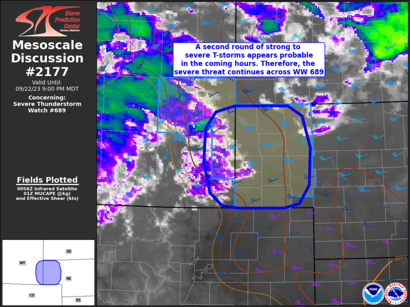
MD 2177 CONCERNING SEVERE THUNDERSTORM WATCH 631… FOR PARTS OF SOUTHEAST TEXAS Mesoscale Discussion 2177 NWS Storm Prediction Center Norman OK 0316 AM CDT Sat Oct 25 2025 Areas affected…Parts of southeast Texas Concerning…Severe Thunderstorm Watch 631… Valid 250816Z – 251015Z The severe weather threat for Severe Thunderstorm Watch 631 continues. SUMMARY…Damaging wind gusts and …
Continue reading SPC MD 2177
M4 MacBook Air vs. M5 MacBook Pro Buyer’s Guide
Apple has refreshed both tiers of its MacBook lineup in 2025, first updating the MacBook Air with the M4 chip and now introducing the MacBook Pro with the new M5 chip, so how do the latest models compare? While the 13- and 15-inch MacBook Air continue to start at $999 and $1,199 respectively, moving to …
Continue reading M4 MacBook Air vs. M5 MacBook Pro Buyer’s Guide
SPC Severe Thunderstorm Watch 630 Status Reports

WW 0630 Status Updates STATUS REPORT ON WW 630 SEVERE WEATHER THREAT CONTINUES RIGHT OF A LINE FROM 30 NNW DRT TO 35 SSE AUS TO 5 SE CRS. FOR ADDITIONAL INFORMATION SEE MESOSCALE DISCUSSION 2176 ..WEINMAN..10/25/25 ATTN…WFO…EWX…FWD…HGX… STATUS REPORT FOR WS 630 SEVERE WEATHER THREAT CONTINUES FOR THE FOLLOWING AREAS TXC019-021-029-041-051-055-137-149-161-185-187-225-271-287-289- 313-325-331-385-395-455-463-465-471-477-250740- TX . …
Continue reading SPC Severe Thunderstorm Watch 630 Status Reports
SPC Severe Thunderstorm Watch 631
WW 631 SEVERE TSTM LA TX CW 250635Z – 251200Z URGENT – IMMEDIATE BROADCAST REQUESTED Severe Thunderstorm Watch Number 631 NWS Storm Prediction Center Norman OK 135 AM CDT Sat Oct 25 2025 The NWS Storm Prediction Center has issued a * Severe Thunderstorm Watch for portions of Southwest Louisiana Southeast Texas Coastal Waters * …
Continue reading SPC Severe Thunderstorm Watch 631
SPC MD 2176

MD 2176 CONCERNING SEVERE POTENTIAL…WATCH LIKELY FOR PARTS OF SOUTHEAST TEXAS Mesoscale Discussion 2176 NWS Storm Prediction Center Norman OK 1256 AM CDT Sat Oct 25 2025 Areas affected…Parts of Southeast Texas Concerning…Severe potential…Watch likely Valid 250556Z – 250730Z Probability of Watch Issuance…80 percent SUMMARY…The severe risk will continue spreading east-southeastward to the Texas Coast …
Continue reading SPC MD 2176
SPC MD 2175
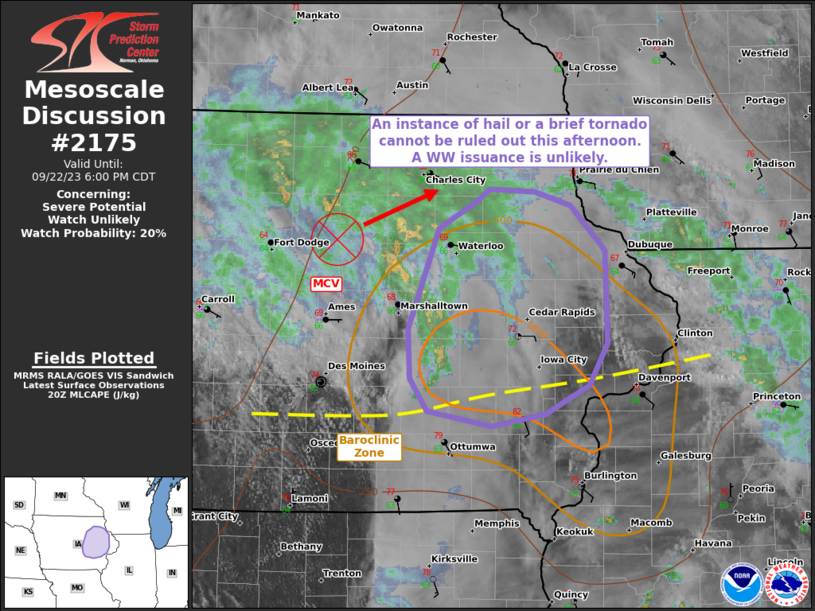
MD 2175 CONCERNING SEVERE THUNDERSTORM WATCH 630… FOR PARTS OF SOUTH CENTRAL TEXAS Mesoscale Discussion 2175 NWS Storm Prediction Center Norman OK 1049 PM CDT Fri Oct 24 2025 Areas affected…parts of south central Texas Concerning…Severe Thunderstorm Watch 630… Valid 250349Z – 250545Z The severe weather threat for Severe Thunderstorm Watch 630 continues. SUMMARY…Strong wind …
Continue reading SPC MD 2175
SPC Severe Thunderstorm Watch 629 Status Reports

WW 0629 Status Updates STATUS REPORT ON WW 629 SEVERE WEATHER THREAT CONTINUES RIGHT OF A LINE FROM 20 E DAL TO 20 SSE DUA. REMAINING VALID PORTION OF WW 629 MAY BE ALLOWED TO EXPIRE AT 25/05Z. ..KERR..10/25/25 ATTN…WFO…FWD…SJT… STATUS REPORT FOR WS 629 SEVERE WEATHER THREAT CONTINUES FOR THE FOLLOWING AREAS TXC257-349-397-250500- TX …
Continue reading SPC Severe Thunderstorm Watch 629 Status Reports