
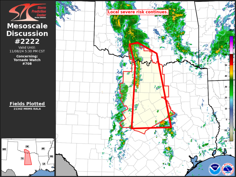
MD 2222 CONCERNING SEVERE POTENTIAL…WATCH POSSIBLE FOR PORTIONS OF SOUTHEAST INTO AND EAST-CENTRAL TEXAS Mesoscale Discussion 2222 NWS Storm Prediction Center Norman OK 1020 AM CST Mon Nov 24 2025 Areas affected…portions of southeast into and east-central Texas Concerning…Severe potential…Watch possible Valid 241620Z – 241745Z Probability of Watch Issuance…60 percent SUMMARY…The severe threat is increasing …
Continue reading SPC MD 2222
Category:Weather
SPC MD 2221
MD 2221 CONCERNING SEVERE POTENTIAL…WATCH POSSIBLE FOR WEST-CENTRAL AND SOUTHWEST TEXAS Mesoscale Discussion 2221 NWS Storm Prediction Center Norman OK 1243 AM CST Mon Nov 24 2025 Areas affected…West-central and Southwest Texas Concerning…Severe potential…Watch possible Valid 240643Z – 240915Z Probability of Watch Issuance…40 percent SUMMARY…An isolated large hail threat may continue into the overnight period …
Continue reading SPC MD 2221
SPC MD 2220
MD 2220 CONCERNING SEVERE THUNDERSTORM WATCH 637… FOR NORTHWEST TEXAS TO THE EDWARDS PLATEAU Mesoscale Discussion 2220 NWS Storm Prediction Center Norman OK 0835 PM CST Sun Nov 23 2025 Areas affected…Northwest Texas to the Edwards Plateau Concerning…Severe Thunderstorm Watch 637… Valid 240235Z – 240430Z The severe weather threat for Severe Thunderstorm Watch 637 continues. …
Continue reading SPC MD 2220
SPC Severe Thunderstorm Watch 637 Status Reports

WW 0637 Status Updates STATUS REPORT ON WW 637 SEVERE WEATHER THREAT CONTINUES RIGHT OF A LINE FROM 30 NW FST TO 15 WSW BGS TO 25 SSE LBB. ..MOORE..11/24/25 ATTN…WFO…MAF…SJT…LUB… STATUS REPORT FOR WS 637 SEVERE WEATHER THREAT CONTINUES FOR THE FOLLOWING AREAS TXC033-081-095-103-105-151-173-207-227-235-253-329-335-353-371- 383-399-413-415-431-435-441-443-451-461-240340- TX . TEXAS COUNTIES INCLUDED ARE BORDEN COKE CONCHO …
Continue reading SPC Severe Thunderstorm Watch 637 Status Reports
SPC Severe Thunderstorm Watch 637
WW 637 SEVERE TSTM TX 232015Z – 240400Z URGENT – IMMEDIATE BROADCAST REQUESTED Severe Thunderstorm Watch Number 637 NWS Storm Prediction Center Norman OK 215 PM CST Sun Nov 23 2025 The NWS Storm Prediction Center has issued a * Severe Thunderstorm Watch for portions of West Texas * Effective this Sunday afternoon and evening …
Continue reading SPC Severe Thunderstorm Watch 637
SPC MD 2219
MD 2219 CONCERNING SEVERE THUNDERSTORM WATCH 637… FOR PORTIONS OF THE PERMIAN BASIN AND THE EDWARDS PLATEAU Mesoscale Discussion 2219 NWS Storm Prediction Center Norman OK 0530 PM CST Sun Nov 23 2025 Areas affected…Portions of the Permian Basin and the Edwards Plateau Concerning…Severe Thunderstorm Watch 637… Valid 232330Z – 240130Z The severe weather threat …
Continue reading SPC MD 2219
SPC MD 2218

MD 2218 CONCERNING SEVERE POTENTIAL…WATCH POSSIBLE FOR PARTS OF THE TEXAS SOUTH PLAINS INTO PECOS VALLEY Mesoscale Discussion 2218 NWS Storm Prediction Center Norman OK 0114 PM CST Sun Nov 23 2025 Areas affected…parts of the Texas South Plains into Pecos Valley Concerning…Severe potential…Watch possible Valid 231914Z – 232215Z Probability of Watch Issuance…60 percent SUMMARY…The …
Continue reading SPC MD 2218
SPC MD 2217

MD 2217 CONCERNING SEVERE POTENTIAL…WATCH UNLIKELY FOR PARTS OF SOUTHWEST KY INTO FAR NORTHERN TN Mesoscale Discussion 2217 NWS Storm Prediction Center Norman OK 1134 PM CST Fri Nov 21 2025 Areas affected…Parts of southwest KY into far northern TN Concerning…Severe potential…Watch unlikely Valid 220534Z – 220730Z Probability of Watch Issuance…5 percent SUMMARY…Localized strong/damaging gusts …
Continue reading SPC MD 2217
SPC MD 2216

MD 2216 CONCERNING SEVERE POTENTIAL…WATCH UNLIKELY FOR OVER NORTHEAST TEXAS AND INTO FAR SOUTHWEST ARKANSAS Mesoscale Discussion 2216 NWS Storm Prediction Center Norman OK 0534 PM CST Thu Nov 20 2025 Areas affected…over northeast Texas and into far southwest Arkansas Concerning…Severe potential…Watch unlikely Valid 202334Z – 210200Z Probability of Watch Issuance…20 percent SUMMARY…A severe storm …
Continue reading SPC MD 2216
SPC MD 2215

MD 2215 CONCERNING SEVERE POTENTIAL…WATCH UNLIKELY FOR PORTIONS OF SOUTH-CENTRAL AND CENTRAL TEXAS Mesoscale Discussion 2215 NWS Storm Prediction Center Norman OK 0318 PM CST Thu Nov 20 2025 Areas affected…portions of south-central and central Texas Concerning…Severe potential…Watch unlikely Valid 202118Z – 202315Z Probability of Watch Issuance…20 percent SUMMARY…A band of thunderstorms and a few …
Continue reading SPC MD 2215