

SPC Day 3-8 Fire Weather Outlook Day 3-8 Fire Weather Outlook NWS Storm Prediction Center Norman OK 0342 PM CST Fri Jan 30 2026 Valid 011200Z – 071200Z …Synopsis… Large scale troughing is expected to predominate the eastern U.S. through much of next week. Multiple mid-level short wave features, related surface cold fronts and precipitation …
Continue reading SPC Day 3-8 Fire Weather Outlook
Category:Weather
SPC Jan 30, 2026 2000 UTC Day 1 Convective Outlook

SPC 2000Z Day 1 Outlook Day 1 Convective Outlook NWS Storm Prediction Center Norman OK 0134 PM CST Fri Jan 30 2026 Valid 302000Z – 311200Z …NO THUNDERSTORM AREAS FORECAST… …SUMMARY… Thunderstorms are not expected today or tonight. …20Z Update… The previous forecast (see below) remains on track. ..Squitieri.. 01/30/2026 .PREV DISCUSSION… /ISSUED 1000 AM …
Continue reading SPC Jan 30, 2026 2000 UTC Day 1 Convective Outlook
SPC Jan 30, 2026 1930 UTC Day 3 Severe Thunderstorm Outlook

SPC 1930Z Day 3 Outlook Day 3 Convective Outlook NWS Storm Prediction Center Norman OK 1245 PM CST Fri Jan 30 2026 Valid 011200Z – 021200Z …NO THUNDERSTORM AREAS FORECAST… …SUMMARY… Thunderstorms are not forecast across the U.S. on Sunday or Sunday night. …Synopsis… An upper trough will continue to migrate across the eastern U.S. …
Continue reading SPC Jan 30, 2026 1930 UTC Day 3 Severe Thunderstorm Outlook
SPC Jan 30, 2026 1730 UTC Day 2 Convective Outlook

SPC 1730Z Day 2 Outlook Day 2 Convective Outlook NWS Storm Prediction Center Norman OK 1058 AM CST Fri Jan 30 2026 Valid 311200Z – 011200Z …NO THUNDERSTORM AREAS FORECAST… …SUMMARY… Thunderstorms are not forecast across the U.S. tomorrow (Saturday). …Synopsis… A pronounced upper trough will amplify along the East Coast as a second upper …
Continue reading SPC Jan 30, 2026 1730 UTC Day 2 Convective Outlook
SPC Jan 30, 2026 1630 UTC Day 1 Convective Outlook
SPC 1630Z Day 1 Outlook Day 1 Convective Outlook NWS Storm Prediction Center Norman OK 1000 AM CST Fri Jan 30 2026 Valid 301630Z – 311200Z …NO THUNDERSTORM AREAS FORECAST… …SUMMARY… Thunderstorms are not expected today or tonight. …Synopsis and Discussion… A large-scale upper trough will amplify over the central/eastern CONUS through tonight. In response, …
Continue reading SPC Jan 30, 2026 1630 UTC Day 1 Convective Outlook
SPC MD 66

MD 0066 CONCERNING HEAVY SNOW FOR NEW ENGLAND INTO SOUTHERN AND EASTERN MAINE Mesoscale Discussion 0066 NWS Storm Prediction Center Norman OK 0626 PM CST Sun Jan 25 2026 Areas affected…New England into southern and eastern Maine Concerning…Heavy snow Valid 260026Z – 260530Z SUMMARY…Heavy snowfall rates on the order of 1-2 inches/hour are expected to …
Continue reading SPC MD 66
SPC MD 65

MD 0065 CONCERNING FREEZING RAIN FOR SOUTHERN VIRGINIA…CENTRAL NORTH CAROLINA Mesoscale Discussion 0065 NWS Storm Prediction Center Norman OK 0550 PM CST Sun Jan 25 2026 Areas affected…southern Virginia…central North Carolina Concerning…Freezing rain Valid 252350Z – 260345Z SUMMARY…Freezing rain accumulations likely this evening. Rates around 0.05-0.10″/hr will be possible. DISCUSSION…Freezing rain reports continue across portions …
Continue reading SPC MD 65
SPC MD 64

MD 0064 CONCERNING HEAVY SNOW FOR NORTHEAST PENNSYLVANIA AND SOUTHEAST NEW YORK INTO NEW ENGLAND Mesoscale Discussion 0064 NWS Storm Prediction Center Norman OK 0302 PM CST Sun Jan 25 2026 Areas affected…northeast Pennsylvania and southeast New York into New England Concerning…Heavy snow Valid 252102Z – 260100Z SUMMARY…Heavy snow will continue from northeast Pennsylvania to …
Continue reading SPC MD 64
SPC Tornado Watch 4 Status Reports
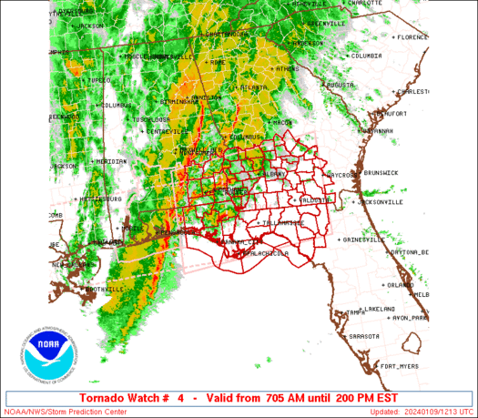
WW 0004 Status Updates STATUS REPORT ON WW 4 SEVERE WEATHER THREAT CONTINUES RIGHT OF A LINE FROM 20 SW MAI TO 45 S MCN. FOR ADDITIONAL INFORMATION SEE MESOSCALE DISCUSSION 0063. ..GRAMS..01/25/26 ATTN…WFO…MOB…BMX…TAE…FFC… STATUS REPORT FOR WT 4 SEVERE WEATHER THREAT CONTINUES FOR THE FOLLOWING AREAS FLC013-063-252240- FL . FLORIDA COUNTIES INCLUDED ARE CALHOUN …
Continue reading SPC Tornado Watch 4 Status Reports
SPC MD 63

MD 0063 CONCERNING TORNADO WATCH 4… FOR CENTRAL/EASTERN FL PANHANDLE AND SOUTHERN GA Mesoscale Discussion 0063 NWS Storm Prediction Center Norman OK 0255 PM CST Sun Jan 25 2026 Areas affected…central/eastern FL Panhandle and southern GA Concerning…Tornado Watch 4… Valid 252055Z – 252230Z The severe weather threat for Tornado Watch 4 continues. SUMMARY…Lingering damaging wind …
Continue reading SPC MD 63