

WW 614 SEVERE TSTM MO 182100Z – 190300Z URGENT – IMMEDIATE BROADCAST REQUESTED Severe Thunderstorm Watch Number 614 NWS Storm Prediction Center Norman OK 400 PM CDT Thu Sep 18 2025 The NWS Storm Prediction Center has issued a * Severe Thunderstorm Watch for portions of Central and Southern Missouri * Effective this Thursday afternoon …
Continue reading SPC Severe Thunderstorm Watch 614
Category:Weather
SPC MD 2099
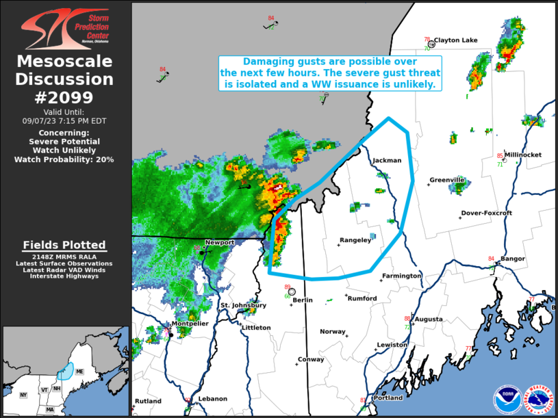
MD 2099 CONCERNING SEVERE THUNDERSTORM WATCH 614… FOR MISSOURI Mesoscale Discussion 2099 NWS Storm Prediction Center Norman OK 0603 PM CDT Thu Sep 18 2025 Areas affected…Missouri Concerning…Severe Thunderstorm Watch 614… Valid 182303Z – 190100Z The severe weather threat for Severe Thunderstorm Watch 614 continues. SUMMARY…Isolated wind/hail can be expected with convection as it spreads …
Continue reading SPC MD 2099
SPC MD 2098

MD 2098 CONCERNING SEVERE POTENTIAL…WATCH POSSIBLE FOR PARTS OF MISSOURI AND FAR SOUTHEAST KANSAS Mesoscale Discussion 2098 NWS Storm Prediction Center Norman OK 0249 PM CDT Thu Sep 18 2025 Areas affected…Parts of Missouri and far southeast Kansas Concerning…Severe potential…Watch possible Valid 181949Z – 182145Z Probability of Watch Issuance…40 percent SUMMARY…Storms will gradually increase in …
Continue reading SPC MD 2098
SPC MD 2097

MD 2097 CONCERNING SEVERE POTENTIAL…WATCH UNLIKELY FOR PORTIONS OF SOUTHEASTERN CALIFORNIA…SOUTHWESTERN ARIZONA…SOUTHERN NEVADA Mesoscale Discussion 2097 NWS Storm Prediction Center Norman OK 0148 PM CDT Thu Sep 18 2025 Areas affected…portions of southeastern California…southwestern Arizona…southern Nevada Concerning…Severe potential…Watch unlikely Valid 181848Z – 182115Z Probability of Watch Issuance…20 percent SUMMARY…A few stronger thunderstorms may produce localized …
Continue reading SPC MD 2097
SPC MD 2096

MD 2096 CONCERNING SEVERE POTENTIAL…WATCH UNLIKELY FOR PARTS OF EASTERN OK…NORTHEAST TX…WESTERN AR…AND FAR SOUTHWEST MO Mesoscale Discussion 2096 NWS Storm Prediction Center Norman OK 0141 PM CDT Thu Sep 18 2025 Areas affected…Parts of eastern OK…northeast TX…western AR…and far southwest MO Concerning…Severe potential…Watch unlikely Valid 181841Z – 182045Z Probability of Watch Issuance…5 percent SUMMARY…Isolated …
Continue reading SPC MD 2096
SPC MD 2095

MD 2095 CONCERNING SEVERE THUNDERSTORM WATCH 613… FOR SOUTHEAST CO TO TX PANHANDLE Mesoscale Discussion 2095 NWS Storm Prediction Center Norman OK 0928 PM CDT Wed Sep 17 2025 Areas affected…Southeast CO to TX Panhandle Concerning…Severe Thunderstorm Watch 613… Valid 180228Z – 180430Z The severe weather threat for Severe Thunderstorm Watch 613 continues. SUMMARY…Strong-locally severe …
Continue reading SPC MD 2095
SPC Severe Thunderstorm Watch 613 Status Reports

WW 0613 Status Updates STATUS REPORT ON WW 613 SEVERE WEATHER THREAT CONTINUES RIGHT OF A LINE FROM 35 E TCC TO 35 NW RTN TO 35 WSW COS. ..SPC..09/18/25 ATTN…WFO…PUB…DDC…ABQ…AMA… STATUS REPORT FOR WS 613 SEVERE WEATHER THREAT CONTINUES FOR THE FOLLOWING AREAS COC009-011-025-041-043-055-061-071-089-099-101-119-180340- CO . COLORADO COUNTIES INCLUDED ARE BACA BENT CROWLEY EL …
Continue reading SPC Severe Thunderstorm Watch 613 Status Reports
SPC MD 2094

MD 2094 CONCERNING SEVERE THUNDERSTORM WATCH 613… FOR SOUTHEAST CO/NORTHEAST NM INTO THE WESTERN OK/TX PANHANDLES Mesoscale Discussion 2094 NWS Storm Prediction Center Norman OK 0547 PM CDT Wed Sep 17 2025 Areas affected…Southeast CO/Northeast NM into the western OK/TX Panhandles Concerning…Severe Thunderstorm Watch 613… Valid 172247Z – 180045Z The severe weather threat for Severe …
Continue reading SPC MD 2094
SPC Severe Thunderstorm Watch 613
WW 613 SEVERE TSTM CO KS NM OK TX 172055Z – 180400Z URGENT – IMMEDIATE BROADCAST REQUESTED Severe Thunderstorm Watch Number 613 NWS Storm Prediction Center Norman OK 255 PM MDT Wed Sep 17 2025 The NWS Storm Prediction Center has issued a * Severe Thunderstorm Watch for portions of Southeast Colorado Southwest Kansas Northeast …
Continue reading SPC Severe Thunderstorm Watch 613
SPC MD 2093
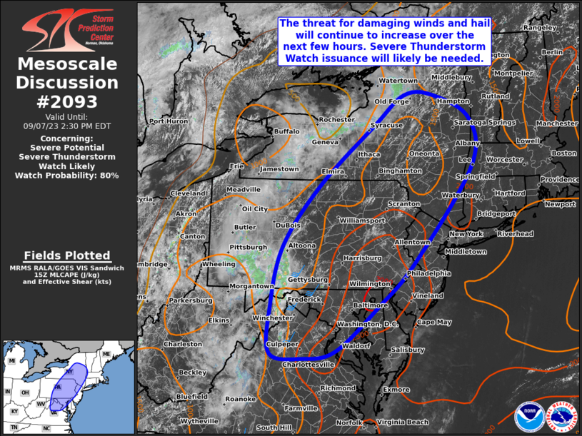
MD 2093 CONCERNING SEVERE POTENTIAL…WATCH UNLIKELY FOR PORTIONS OF SOUTHERN INTO CENTRAL IOWA Mesoscale Discussion 2093 NWS Storm Prediction Center Norman OK 0501 PM CDT Wed Sep 17 2025 Areas affected…portions of southern into central Iowa Concerning…Severe potential…Watch unlikely Valid 172201Z – 172330Z Probability of Watch Issuance…5 percent SUMMARY…A couple of additional severe gusts are …
Continue reading SPC MD 2093