

MD 0002 CONCERNING SNOW SQUALL FOR NORTHERN MID-ATLANTIC INTO THE HUDSON VALLEY Mesoscale Discussion 0002 NWS Storm Prediction Center Norman OK 0200 AM CST Thu Jan 01 2026 Areas affected…Northern Mid-Atlantic into the Hudson Valley Concerning…Snow Squall Valid 010800Z – 011130Z SUMMARY…A snow squall currently over central/eastern Pennsylvania will continue east-southeastward across the northern Mid-Atlantic …
Continue reading SPC MD 2
Category:Weather
SPC MD 1

MD 0001 CONCERNING SNOW SQUALL FOR PORTIONS OF CENTRAL AND SOUTHERN NEW YORK INTO CENTRAL PENNSYLVANIA…WESTERN MARYLAND…EXTREME NORTHEASTERN WEST VIRGINIA Mesoscale Discussion 0001 NWS Storm Prediction Center Norman OK 1026 PM CST Wed Dec 31 2025 Areas affected…portions of central and southern New York into central Pennsylvania…western Maryland…extreme northeastern West Virginia Concerning…Snow Squall Valid 010426Z …
Continue reading SPC MD 1
SPC MD 2288
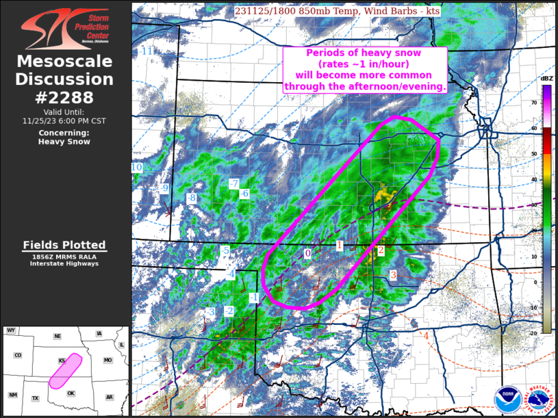
MD 2288 CONCERNING SNOW SQUALL FOR PORTIONS OF NORTHERN OHIO…NORTHWESTERN PENNSYLVANIA AND SOUTHWESTERN NEW YORK Mesoscale Discussion 2288 NWS Storm Prediction Center Norman OK 0542 PM CST Wed Dec 31 2025 Areas affected…portions of northern Ohio…northwestern Pennsylvania and southwestern New York Concerning…Snow Squall Valid 312342Z – 010415Z SUMMARY…A snow squall may develop in the next …
Continue reading SPC MD 2288
SPC MD 2287
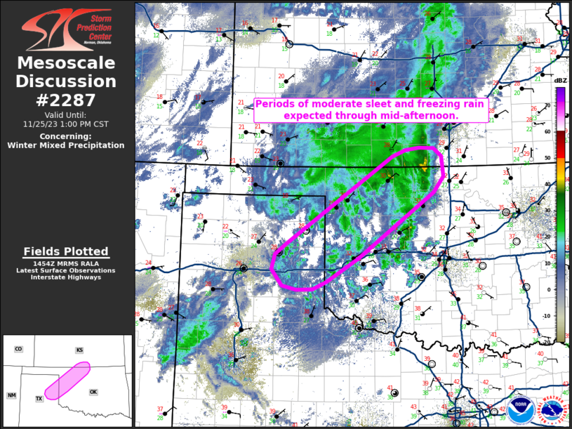
MD 2287 CONCERNING SNOW SQUALL FOR NORTHEAST OHIO…NORTHWEST PENNSYLVANIA…WESTERN NEW YORK Mesoscale Discussion 2287 NWS Storm Prediction Center Norman OK 0214 PM CST Mon Dec 29 2025 Areas affected…Northeast Ohio…northwest Pennsylvania…western New York Concerning…Snow Squall Valid 292014Z – 300015Z SUMMARY…Snow squall conditions are possible as a secondary cold front moves off of Lake Erie. Moderate …
Continue reading SPC MD 2287
SPC MD 2286
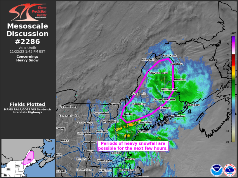
MD 2286 CONCERNING HEAVY SNOW FOR PARTS OF UPPER MICHIGAN AND FAR NORTHERN LOWER MICHIGAN Mesoscale Discussion 2286 NWS Storm Prediction Center Norman OK 0332 AM CST Mon Dec 29 2025 Areas affected…Parts of Upper Michigan and far northern Lower Michigan Concerning…Heavy snow Valid 290932Z – 291530Z SUMMARY…Banded heavy snow with rates of 1-2 inches …
Continue reading SPC MD 2286
SPC MD 2285
MD 2285 CONCERNING FREEZING RAIN FOR PORTIONS OF EASTERN NEW YORK AND NORTHERN MASSACHUSETTS INTO CENTRAL AND NORTHERN VERMONT AND NEW HAMPSHIRE Mesoscale Discussion 2285 NWS Storm Prediction Center Norman OK 0840 PM CST Sun Dec 28 2025 Areas affected…portions of eastern New York and northern Massachusetts into central and northern Vermont and New Hampshire …
Continue reading SPC MD 2285
SPC MD 2284
MD 2284 CONCERNING TORNADO WATCH 643… FOR CENTRAL INDIANA…WESTERN KENTUCKY AND TENNESSEE…EXTREME SOUTHERN ILLINOIS Mesoscale Discussion 2284 NWS Storm Prediction Center Norman OK 0658 PM CST Sun Dec 28 2025 Areas affected…central Indiana…western Kentucky and Tennessee…extreme southern Illinois Concerning…Tornado Watch 643… Valid 290058Z – 290400Z The severe weather threat for Tornado Watch 643 continues. SUMMARY…Areas …
Continue reading SPC MD 2284
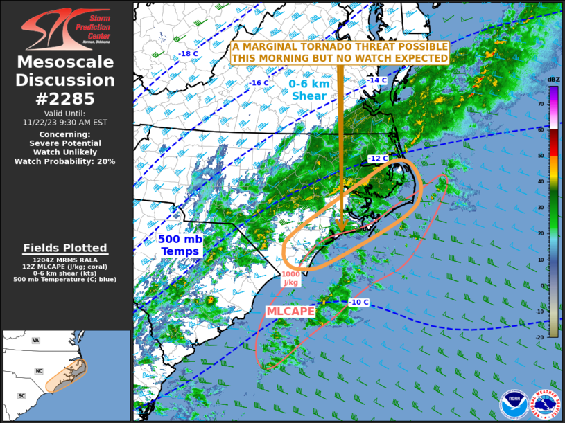
SPC MD 2283

MD 2283 CONCERNING BLIZZARD FOR CENTRAL MINNESOTA INTO NORTHERN IOWA Mesoscale Discussion 2283 NWS Storm Prediction Center Norman OK 0553 PM CST Sun Dec 28 2025 Areas affected…Central Minnesota into northern Iowa Concerning…Blizzard Valid 282353Z – 290500Z SUMMARY…Blizzard conditions are expected to gradually increase through the evening across portions of the Upper Midwest. 30-40 mph …
Continue reading SPC MD 2283
SPC Tornado Watch 643 Status Reports

WW 0643 Status Updates STATUS REPORT ON WW 643 SEVERE WEATHER THREAT CONTINUES RIGHT OF A LINE FROM 25 SSW CGI TO 20 NE CGI TO 25 SSE MVN TO 45 NNW EVV TO 15 E HUF TO 35 ESE LAF TO 40 NNW FWA. ..JEWELL..12/29/25 ATTN…WFO…PAH…LSX…ILX…LOT…IND…IWX…LMK… STATUS REPORT FOR WT 643 SEVERE WEATHER THREAT …
Continue reading SPC Tornado Watch 643 Status Reports
SPC Tornado Watch 643
WW 643 TORNADO IL IN KY MO 282045Z – 290200Z URGENT – IMMEDIATE BROADCAST REQUESTED Tornado Watch Number 643 NWS Storm Prediction Center Norman OK 345 PM EST Sun Dec 28 2025 The NWS Storm Prediction Center has issued a * Tornado Watch for portions of Southern and Central Illinois Western and Central Indiana Western …
Continue reading SPC Tornado Watch 643