

WW 0648 Status Updates STATUS REPORT ON WW 648 SEVERE WEATHER THREAT CONTINUES RIGHT OF A LINE FROM 15 ENE RUT TO 5 SE EEN TO 80 ESE PSM. ..THORNTON..08/26/24 ATTN…WFO…OKX…BOX…ALY…GYX… STATUS REPORT FOR WS 648 SEVERE WEATHER THREAT CONTINUES FOR THE FOLLOWING AREAS CTC001-003-005-007-009-011-013-015-262240- CT . CONNECTICUT COUNTIES INCLUDED ARE FAIRFIELD HARTFORD LITCHFIELD MIDDLESEX …
Continue reading SPC Severe Thunderstorm Watch 648 Status Reports
Category:Weather
SPC MD 2000
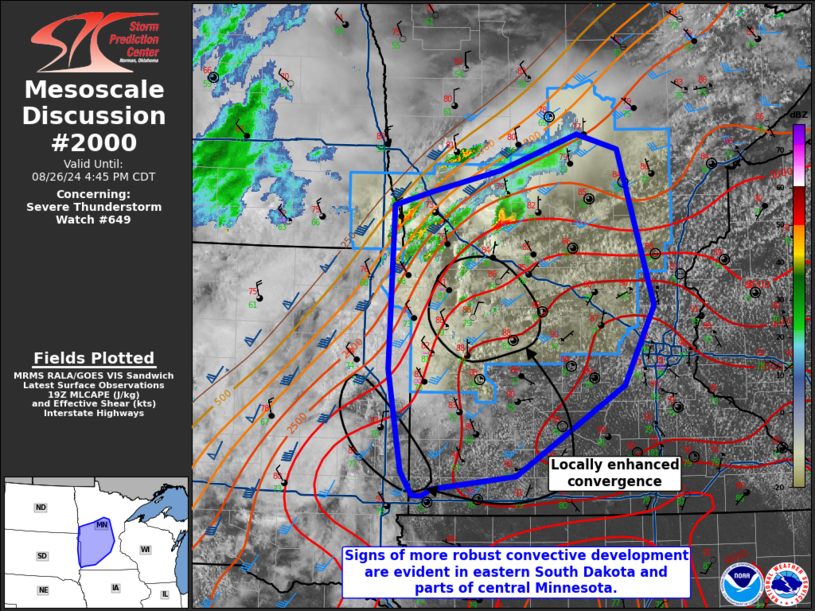
MD 2000 CONCERNING SEVERE THUNDERSTORM WATCH 649… FOR FAR EASTERN SOUTH DAKOTA INTO CENTRAL/SOUTHWEST MINNESOTA Mesoscale Discussion 2000 NWS Storm Prediction Center Norman OK 0243 PM CDT Mon Aug 26 2024 Areas affected…Far eastern South Dakota into Central/Southwest Minnesota Concerning…Severe Thunderstorm Watch 649… Valid 261943Z – 262145Z The severe weather threat for Severe Thunderstorm Watch …
Continue reading SPC MD 2000
SPC Severe Thunderstorm Watch 648
WW 648 SEVERE TSTM CT MA NH NY RI VT CW 261705Z – 262300Z URGENT – IMMEDIATE BROADCAST REQUESTED Severe Thunderstorm Watch Number 648 NWS Storm Prediction Center Norman OK 105 PM EDT Mon Aug 26 2024 The NWS Storm Prediction Center has issued a * Severe Thunderstorm Watch for portions of Connecticut Massachusetts Southern …
Continue reading SPC Severe Thunderstorm Watch 648
SPC MD 1994
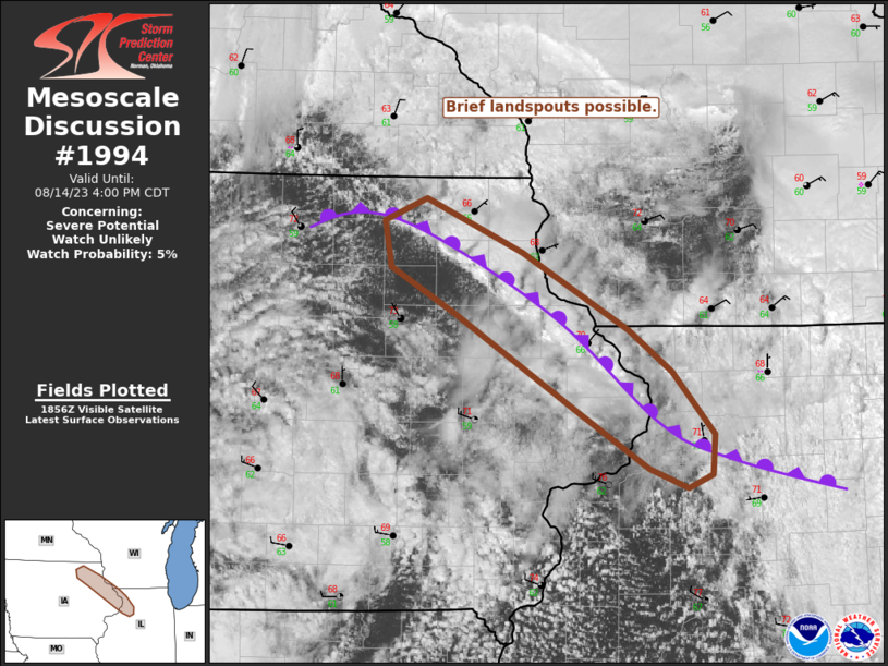
MD 1994 CONCERNING SEVERE POTENTIAL…WATCH UNLIKELY FOR PORTIONS OF CENTRAL WY Mesoscale Discussion 1994 NWS Storm Prediction Center Norman OK 0958 AM CDT Mon Aug 26 2024 Areas affected…portions of central WY Concerning…Severe potential…Watch unlikely Valid 261458Z – 261630Z Probability of Watch Issuance…20 percent SUMMARY…Isolated thunderstorms may sporadically produce large hail to near 1.25 inch …
Continue reading SPC MD 1994
SPC MD 1993

MD 1993 CONCERNING SEVERE POTENTIAL…WATCH UNLIKELY FOR SOUTHEAST ND INTO NORTHEAST SD AND WESTERN MN Mesoscale Discussion 1993 NWS Storm Prediction Center Norman OK 1153 PM CDT Sun Aug 25 2024 Areas affected…Southeast ND into northeast SD and western MN Concerning…Severe potential…Watch unlikely Valid 260453Z – 260700Z Probability of Watch Issuance…20 percent SUMMARY…Isolated strong to …
Continue reading SPC MD 1993
SPC MD 1992

MD 1992 CONCERNING SEVERE THUNDERSTORM WATCH 647… FOR NORTHEAST SD Mesoscale Discussion 1992 NWS Storm Prediction Center Norman OK 1050 PM CDT Sun Aug 25 2024 Areas affected…Northeast SD Concerning…Severe Thunderstorm Watch 647… Valid 260350Z – 260515Z The severe weather threat for Severe Thunderstorm Watch 647 continues. SUMMARY…A localized damaging-wind threat may spread into northeast …
Continue reading SPC MD 1992
SPC Severe Thunderstorm Watch 647 Status Reports

WW 0647 Status Updates STATUS REPORT ON WW 647 SEVERE WEATHER THREAT CONTINUES RIGHT OF A LINE FROM 35 W YKN TO 25 N ANW TO 40 ENE PIR. ..DEAN..08/26/24 ATTN…WFO…LBF…FSD…ABR…UNR… STATUS REPORT FOR WS 647 SEVERE WEATHER THREAT CONTINUES FOR THE FOLLOWING AREAS SDC003-005-015-017-023-025-035-043-053-059-061-073-077-085-097- 111-115-260340- SD . SOUTH DAKOTA COUNTIES INCLUDED ARE AURORA BEADLE …
Continue reading SPC Severe Thunderstorm Watch 647 Status Reports
SPC Severe Thunderstorm Watch 646 Status Reports

WW 0646 Status Updates STATUS REPORT ON WW 646 SEVERE WEATHER THREAT CONTINUES RIGHT OF A LINE FROM 40 S 4BL TO 55 NNE GJT TO 15 SSW CAG. ..SPC..08/26/24 ATTN…WFO…GJT…SLC…CYS…RIW… STATUS REPORT FOR WS 646 SEVERE WEATHER THREAT CONTINUES FOR THE FOLLOWING AREAS COC029-033-045-077-083-085-103-107-113-260240- CO . COLORADO COUNTIES INCLUDED ARE DELTA DOLORES GARFIELD MESA …
Continue reading SPC Severe Thunderstorm Watch 646 Status Reports
SPC MD 1991

MD 1991 CONCERNING SEVERE THUNDERSTORM WATCH 647… FOR EASTERN SD INTO EXTREME NORTH-CENTRAL NE Mesoscale Discussion 1991 NWS Storm Prediction Center Norman OK 0750 PM CDT Sun Aug 25 2024 Areas affected…Eastern SD into extreme north-central NE Concerning…Severe Thunderstorm Watch 647… Valid 260050Z – 260215Z The severe weather threat for Severe Thunderstorm Watch 647 continues. …
Continue reading SPC MD 1991
SPC MD 1990

MD 1990 CONCERNING SEVERE POTENTIAL…WATCH UNLIKELY FOR NORTHEAST WY INTO WESTERN SD AND EXTREME SOUTHEAST MT Mesoscale Discussion 1990 NWS Storm Prediction Center Norman OK 0539 PM CDT Sun Aug 25 2024 Areas affected…Northeast WY into western SD and extreme southeast MT Concerning…Severe potential…Watch unlikely Valid 252239Z – 260045Z Probability of Watch Issuance…20 percent SUMMARY…Isolated …
Continue reading SPC MD 1990