
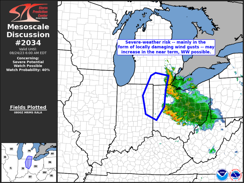
MD 2034 CONCERNING SEVERE POTENTIAL…WATCH POSSIBLE FOR SOUTHERN PORTIONS OF LOWER MICHIGAN…PARTS OF WESTERN OHIO…AND PARTS OF EASTERN INDIANA
Mesoscale Discussion 2034
NWS Storm Prediction Center Norman OK
0303 AM CDT Thu Aug 24 2023
Areas affected…southern portions of Lower Michigan…parts of
western Ohio…and parts of eastern Indiana
Concerning…Severe potential…Watch possible
Valid 240803Z – 241000Z
Probability of Watch Issuance…40 percent
SUMMARY…Potential for locally damaging wind gusts may increase
over the next 1 to 2 hours. This could warrant consideration for
possible WW issuance.
DISCUSSION…Latest radar loop shows widespread thunderstorms over
southeastern Lower Michigan, and southward across Lake Erie into a
large portion of Ohio. The most intense storms are occurring along
the leading/western edge of the broader area of convection, with a
gradual southwestward advance noted.
The storms are generally slightly elevated, occurring to the cool
side of a north-south warm front, where warm advection associated
with a 30 to 40 kt west-northwesterly low-level jet is enhancing
ascent.
Near and west of the leading edge of the convection, an unusually
moist/strongly unstable warm sector is evident — with dewpoints in
the upper 70s supporting 3500-plus J/KG mixed-layer CAPE from
southern lower Michigan southward roughly along the Ohio/Indiana
border. While this warm-sector airmass is moderately capped
(evidenced by the restriction of a more rapid westward expansion of
convection), storms are making gradual westward progress toward/into
the instability axis, in tandem with convective outflow.
While warm sector capping will likely continue to hinder more
aggressive westward advance of the storms, a narrow zone of greater
severe potential exists as the leading edge of the convection
impinges on the very moist/unstable warm sector. A recent gust to
80 kt occurred in the Detroit metro area, and though additional
reports of strong gusts have been sparse at best, at least a modest
increase in risk seems probable. We will continue to monitor the
westward progression of convection, as it pertains to possible need
for WW consideration.
..Goss/Guyer.. 08/24/2023
…Please see www.spc.noaa.gov for graphic product…
ATTN…WFO…CLE…ILN…DTX…IWX…GRR…IND…
LAT…LON 42408462 42248362 41398386 40468396 39718455 40048535
41118557 42258497 42408462