
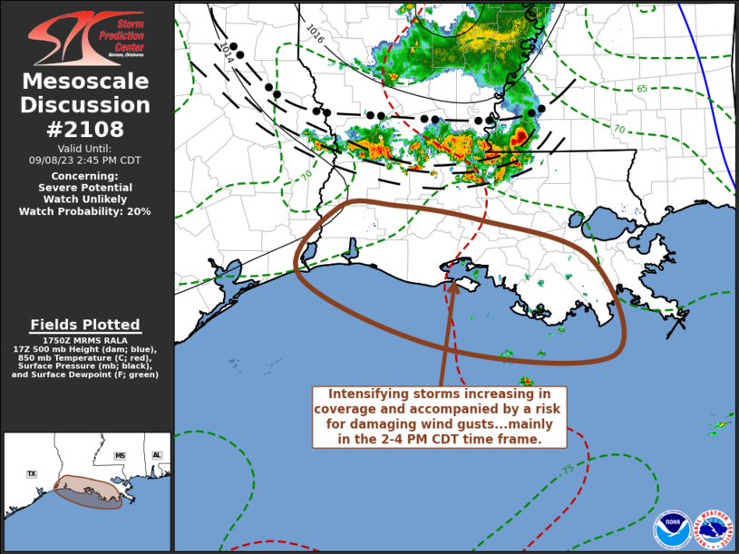
MD 2108 CONCERNING SEVERE POTENTIAL…WATCH UNLIKELY FOR SOUTHERN LOUISIANA AND ADJACENT UPPER TEXAS COASTAL AREAS
Mesoscale Discussion 2108
NWS Storm Prediction Center Norman OK
1252 PM CDT Fri Sep 08 2023
Areas affected…southern Louisiana and adjacent upper Texas coastal
areas
Concerning…Severe potential…Watch unlikely
Valid 081752Z – 081945Z
Probability of Watch Issuance…20 percent
SUMMARY…Potential for damaging wind gusts may increase with
intensifying thunderstorm activity, mainly near Louisiana and
adjacent upper Texas coastal areas during the 2-4 PM CDT time frame.
Due to the limited nature of the risk in area and time, it is not
clear that a severe weather watch is needed, but trends are still
being monitored.
DISCUSSION…Convective outflow, and preceding gravity waves,
continue to advance south-southwestward across central into southern
Louisiana at around 30 kt. While relatively warm air in the
850-700 mb layer continues to provide inhibition for the seasonably
moist boundary layer preceding the outflow, low-level lift has
supported renewed vigorous thunderstorm development. Based on
forecast and observed morning forecast soundings, it is not clear
that CAPE differs appreciably for boundary-layer parcels versus
elevated moist parcels, and it appears on the order of 2000 J/kg,
but may approach 3000 J/kg near immediate coastal areas.
Given the current motion of the convective outflow and further
reduction in inhibition with additional boundary layer warming,
more substantive convective intensification and upscale growth
appears possible near immediate coastal areas by the 19-20Z. Before
activity advances offshore, there may be a window of opportunity for
a few localized downbursts, and cold pool strengthening, capable of
supporting potentially damaging wind gusts.
..Kerr/Guyer.. 09/08/2023
…Please see www.spc.noaa.gov for graphic product…
ATTN…WFO…LIX…LCH…
LAT…LON 30419274 30269171 29839033 28769004 28859213 29619395
30399348 30419274