
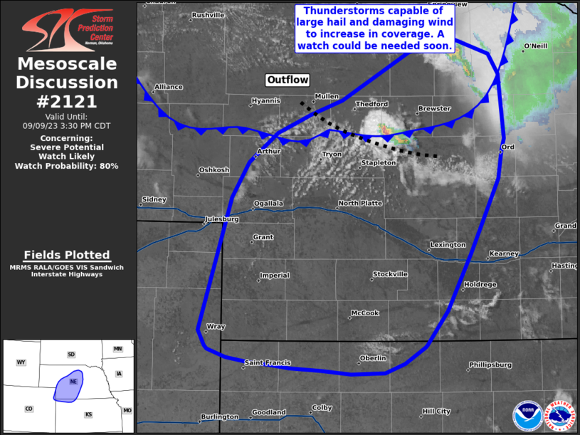
MD 2121 CONCERNING SEVERE POTENTIAL…WATCH LIKELY FOR CENTRAL/WESTERN NEBRASKA AND NORTHWESTERN KANSAS
Mesoscale Discussion 2121
NWS Storm Prediction Center Norman OK
0127 PM CDT Sat Sep 09 2023
Areas affected…Central/Western Nebraska and Northwestern Kansas
Concerning…Severe potential…Watch likely
Valid 091827Z – 092030Z
Probability of Watch Issuance…80 percent
SUMMARY…Thunderstorms capable of large hail and damaging winds to
increase in coverage. A watch could be needed soon.
DISCUSSION…Agitated cumulus development has been noted on visible
satellite at the intersection of a cold front draped across central
Nebraska a southward advancing outflow boundary from convection to
the northeast of the front. Initial development is largely elevated
with mid-level capping quickly eroding with daytime heating and
temperatures in the upper 80s. MLCAPE around 1500 J/kg and deep
layer shear around 35-40 kts will support organized storms with
potential for supercells capable of large hail and damaging wind. A
watch could be needed soon.
..Thornton/Guyer.. 09/09/2023
…Please see www.spc.noaa.gov for graphic product…
ATTN…WFO…GID…LBF…GLD…BOU…
LAT…LON 41210195 41510175 41760144 41920105 42050071 42459994
42569942 42449904 42269893 41719887 41619890 41389895
40969915 40739926 40519938 40259953 39969976 39949977
39800000 39720022 39710061 39740094 39770128 39800152
39810175 39860200 39930220 39950223 40080230 41210195