
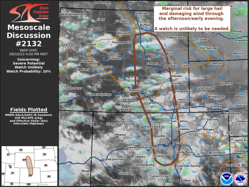
MD 2132 CONCERNING SEVERE POTENTIAL…WATCH UNLIKELY FOR PORTIONS OF EASTERN WYOMING AND NORTH-CENTRAL COLORADO
Mesoscale Discussion 2132
NWS Storm Prediction Center Norman OK
0306 PM CDT Sun Sep 10 2023
Areas affected…Portions of Eastern Wyoming and North-central
Colorado
Concerning…Severe potential…Watch unlikely
Valid 102006Z – 102200Z
Probability of Watch Issuance…20 percent
SUMMARY…Marginal risk for large hail and damaging wind through the
afternoon/early evening. A watch is unlikely to be needed at this
time.
DISCUSSION…Additional thunderstorm development is expected across
eastern Wyoming southward to the Front Range through the afternoon
and early evening. A swath of MLCAPE around 250-500 J/kg amid deep
layer shear 40-45 kts will support development across the higher
terrain of a few supercells, capable of large hail and damaging
winds. A few isolated instances of hail exceeding 1″ will be
possible, given steep lapse rates and strong deep layer shear
profiles with sufficient CAPE. However, overall lack of more robust
buoyancy should keep the large hail threat isolated, which will
likely keep the spatial extent of the threat minimal. Storm mode
will likely remain semi-discrete with small mix-mode clusters, which
will support a few severe gusts but overall keep this threat fairly
localized as well. Trends are being monitored but a watch is
unlikely at this time.
..Thornton/Guyer.. 09/10/2023
…Please see www.spc.noaa.gov for graphic product…
ATTN…WFO…UNR…PUB…BOU…CYS…RIW…
LAT…LON 39740597 40410603 41950685 43850698 44040689 44130628
44010583 43640548 43270525 42790509 41300475 40540461
39630459 39200472 38980505 38930538 39010560 39140582
39740597