
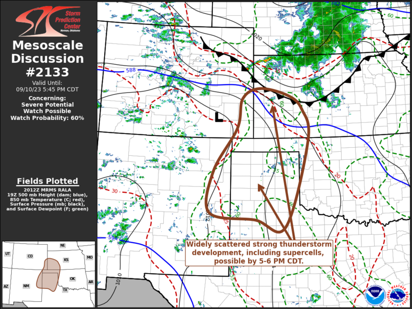
MD 2133 CONCERNING SEVERE POTENTIAL…WATCH POSSIBLE FOR PARTS OF NORTHEASTERN NEW MEXICO…SOUTHEASTERN COLORADO…AND THE TEXAS AND OKLAHOMA PANHANDLES INTO SOUTHWESTERN KANSAS
Mesoscale Discussion 2133
NWS Storm Prediction Center Norman OK
0313 PM CDT Sun Sep 10 2023
Areas affected…parts of northeastern New Mexico…southeastern
Colorado…and the Texas and Oklahoma Panhandles into southwestern
Kansas
Concerning…Severe potential…Watch possible
Valid 102013Z – 102245Z
Probability of Watch Issuance…60 percent
SUMMARY…Isolated to widely scattered strong thunderstorm
development is possible through 5-6 PM CDT. This may include an
isolated supercell or two, posing a risk for severe hail, locally
strong surface gusts and perhaps a brief tornado.
DISCUSSION…Low-level moistening is still ongoing within weak, but
slowly deepening surface troughing to the lee of the southern
Rockies. This is occurring beneath warm and capping elevated
mixed-layer, and mid-level ridging to the north of a still fairly
prominent subtropical high centered over the northwestern Mexican
Plateau. In response to a series of short wave perturbations
progressing around the periphery of the ridge in the near term, and,
later, digging mid-level troughing across the northern Great Plains,
mid-level heights are gradually beginning to fall.
It appears that large-scale forcing for ascent will lead to
increasing convective development spreading off the Front Range into
the destabilizing boundary layer across and east of northeastern New
Mexico and southeastern Colorado by early this evening. Potential
for the initiation of sustained thunderstorm development in advance
of this activity, through late afternoon, remains more unclear.
Based on objective analysis, mixed-layer CAPE remains fairly modest
to the north of the Texas Panhandle vicinity, currently maximized
around 1000 J/kg near the Colorado/Kansas border. However, shear
for boundary-layer based thunderstorm development is sufficient for
supercells beneath 30 kt west-northwesterly mid-level flow (around
500 mb). Farther south, mixed-layer CAPE is more substantive, but
shear remains weaker.
With additional surface heating, it appears possible that weakening
of lingering mid-level inhibition may become sufficient for at least
widely scattered thunderstorm development. A zone of enhanced
lower/mid-tropospheric warm advection, currently centered to the
west/northwest of Garden City KS, may provide one potential focus
for thunderstorm initiation during the next hour or two. As this
activity acquires increasing inflow of destabilizing boundary-layer,
it may rapidly intensify and organize, accompanied by increasing
potential for severe hail and perhaps some risk for a tornado
through 22-23Z.
..Kerr/Guyer.. 09/10/2023
…Please see www.spc.noaa.gov for graphic product…
ATTN…WFO…OUN…DDC…GLD…LUB…AMA…PUB…ABQ…
LAT…LON 37350277 38420253 38800174 38540046 38029982 36909958
33770062 34030194 34280395 35780381 37350277