
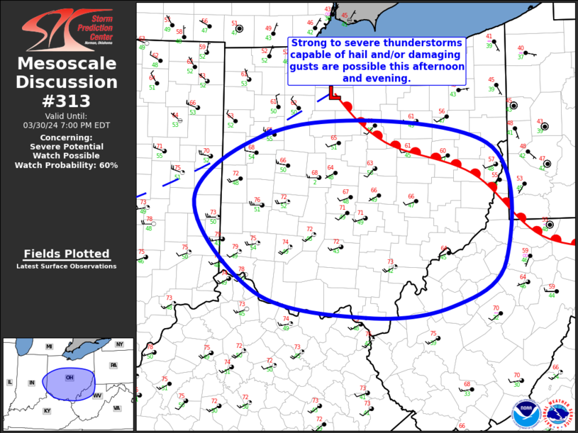
MD 0313 CONCERNING SEVERE POTENTIAL…WATCH POSSIBLE FOR FAR EAST-CENTRAL IN INTO CENTRAL/SOUTHERN OH
Mesoscale Discussion 0313
NWS Storm Prediction Center Norman OK
0327 PM CDT Sat Mar 30 2024
Areas affected…Far East-Central IN into Central/Southern OH
Concerning…Severe potential…Watch possible
Valid 302027Z – 302300Z
Probability of Watch Issuance…60 percent
SUMMARY…Strong to severe thunderstorms capable of hail (1″ to
1.75″) and/or damaging gusts (from 40 to 60 mph) are possible this
afternoon and evening.
DISCUSSION…Latest surface analysis places a low over north-central
OH (about 30 miles east-northeast of FDY). A warm front extends
east-southeastward from this low across southeast OH into far
northern WV. A modest surface trough also extends southwestward from
this low across central IN and central IL. Filtered heating in the
wake of the early morning cloud cover has allowed temperatures to
climb into the upper 60s/low 70s within the warm sector
south/southwest of the warm front and to the east of the surface
troughing. Low-level moisture remains modest, with dewpoints in the
upper 40s/low 50s. Even though the low-level thermodynamic
conditions are relatively modest, these conditions combined cold
mid-level temperatures (i.e. around -20 deg C at 500 mb) and
associated steep mid-level lapse rates are contributing to air mass
destabilization.
This destabilization is verified by increasingly agitated cumulus
just ahead of the surface trough over far east-central IN and far
western OH. Given the veered low-level flow, convergence along the
boundary is limited. However, ascent along the boundary will be
augmented by large-scale ascent attendant to a fast-moving shortwave
embedded within the strong westerly flow aloft. This combination of
ascent and destabilization will likely result in convective
initiation. Buoyancy will be modest, but deep-layer vertical shear
will be strong. Recent mesoanalysis estimates 50 to 60 kt of 0-6 km
bulk shear across the region. As such, any deeper updrafts could
become organized, capable of producing large hail (1″ to 1.75″)
and/or damaging wind gusts (40 to 60 mph this afternoon and evening.
..Mosier/Thompson.. 03/30/2024
…Please see www.spc.noaa.gov for graphic product…
ATTN…WFO…PBZ…RLX…CLE…ILN…IWX…IND…
LAT…LON 40828361 40618083 39268057 38738137 38618264 38898430
40018520 40828361