
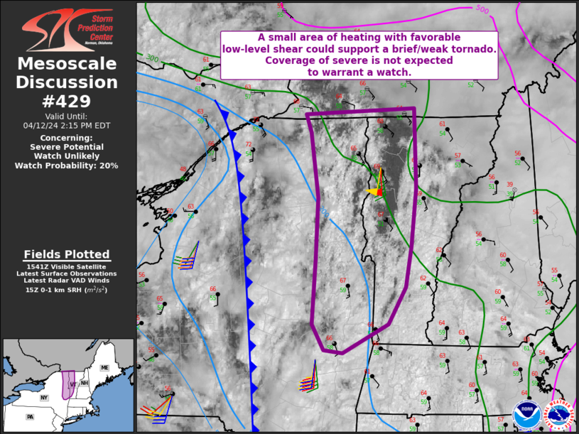
MD 0429 CONCERNING SEVERE POTENTIAL…WATCH UNLIKELY FOR NORTHEASTERN NEW YORK INTO VERMONT
Mesoscale Discussion 0429
NWS Storm Prediction Center Norman OK
1045 AM CDT Fri Apr 12 2024
Areas affected…northeastern New York into Vermont
Concerning…Severe potential…Watch unlikely
Valid 121545Z – 121815Z
Probability of Watch Issuance…20 percent
SUMMARY…Isolated strong to severe storms cannot be ruled out this
afternoon from northeastern New York into Vermont. A brief/weak
tornado or locally strong gusts will be possible.
DISCUSSION…Visible satellite shows areas of clearing, which is
allowing for relatively warm conditions to develop. Surface
temperatures are already in the upper 60s F, which is warmer than
several models indicate. This has led to the development of several
hundred J/kg SBCAPE.
Area VWPs show 0-1 SRH over 200 m2/s2, which is quite supportive of
rotation within storms. This, along with a relatively high RH
boundary layer, and lift ahead of the front/surface trough, suggest
an uptick in at least low-topped thunderstorm coverage may occur.
Whether individual cells form, or north-south line segments, storms
may acquire sufficient low-level rotation for a brief tornado risk,
within a small zone where heating is most prominent.
..Jewell/Goss.. 04/12/2024
…Please see www.spc.noaa.gov for graphic product…
ATTN…WFO…BTV…ALY…
LAT…LON 45097269 44307266 43717273 43307281 42947306 42647368
42677394 42947410 43607406 44207403 44857413 45047420
45097269