
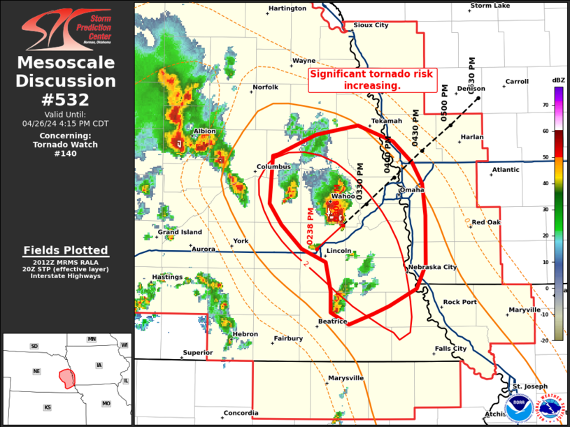
MD 0532 CONCERNING TORNADO WATCH 140… FOR PORTIONS OF EASTERN NEBRASKA
Mesoscale Discussion 0532
NWS Storm Prediction Center Norman OK
0314 PM CDT Fri Apr 26 2024
Areas affected…portions of eastern Nebraska
Concerning…Tornado Watch 140…
Valid 262014Z – 262115Z
The severe weather threat for Tornado Watch 140 continues.
SUMMARY…Well-developed supercells are moving into an environment
very favorable for tornadoes. A corridor of heightened risk for
significant tornadoes is emerging across eastern/southeastern NE.
DISCUSSION…Ongoing storms across southeastern NE have rapidly
evolved into well-organized supercells over the past few hours. The
environment ahead of these storms is becoming increasingly favorable
for significant tornadoes near the modifying warm front over the
NE/IA border. ESRH of 300 m2/s2 and STP values of 2-3 from SPC
mesoanalysis indicate the environment could support strong (EF2-EF3)
tornadoes with these organized supercells. Current radar data shows
storm motions of 215-225 deg at 30-35 kt. This would place these
storms near or just west of the Omaha metro in the next 60-90
minutes.
..Lyons.. 04/26/2024
…Please see www.spc.noaa.gov for graphic product…
ATTN…WFO…EAX…OAX…
LAT…LON 41789633 41669599 41499580 41339570 41099567 40889567
40739566 40549576 40429602 40369619 40289642 40369661
40529661 40749666 40859690 41039710 41199721 41559719
41569714 41719676 41789633