
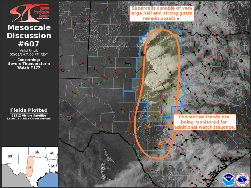
MD 0607 CONCERNING SEVERE THUNDERSTORM WATCH 177… FOR NORTHWEST TX INTO SOUTHWEST TX INTO THE TX HILL COUNTRY
Mesoscale Discussion 0607
NWS Storm Prediction Center Norman OK
0535 PM CDT Thu May 02 2024
Areas affected…Northwest TX into Southwest TX into the TX Hill
Country
Concerning…Severe Thunderstorm Watch 177…
Valid 022235Z – 030000Z
The severe weather threat for Severe Thunderstorm Watch 177
continues.
SUMMARY…Supercells capable of very large hail up to 2-3″ in
diameter and gusts up to 75 mph remain possible. Additional
development is possible over the Texas Hill Country and trends will
be monitored for additional watch issuance.
DISCUSSION…Regional radar imagery depicts two mature supercells,
one in King County and the other farther south in Runnels County.
Visible satellite imagery reveals several attempts at additional
development between these two mature storms. Environmental
conditions support supercells and the general expectation is for the
newer development to mature. Primary severe risk with these storms
is very large hail around 2″ to 3″ in diameter. A few damaging gusts
up to 75 mph are possible as well.
Farther south (from southwest TX into the TX Hill Country), cumulus
has been gradually deepening, although convective
initiation/lightning has not been realized. The mesoscale
environment in this area will be influenced by a westward-moving
outflow boundary, which could provide the additional lift needed for
convective initiation. Large to very hail is possible with new
updrafts. However, cooler temperatures behind the outflow could act
as a deterrent for sustained development, and the overall
longevity/severity of this newer development is uncertain. Some
initiation is possible south of Severe Thunderstorm Watch 177, and
convective trends will be monitored closely in this area for
additional watch issuance.
..Mosier/Guyer.. 05/02/2024
…Please see www.spc.noaa.gov for graphic product…
ATTN…WFO…FWD…OUN…EWX…SJT…LUB…
LAT…LON 30330071 31780037 33900003 33529859 29369895 28799982
29350051 30330071