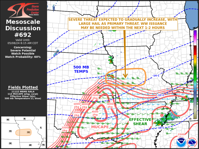
MD 0692 CONCERNING SEVERE POTENTIAL…WATCH POSSIBLE FOR EASTERN KANSAS…CENTRAL AND WESTERN MISSOURI
Mesoscale Discussion 0692
NWS Storm Prediction Center Norman OK
0614 AM CDT Wed May 08 2024
Areas affected…Eastern Kansas…Central and Western Missouri
Concerning…Severe potential…Watch possible
Valid 081114Z – 081315Z
Probability of Watch Issuance…60 percent
SUMMARY…The threat for large hail will likely continue, as storm
coverage gradually expands over the next couple of hours from
eastern Kansas into western and central Missouri. New weather watch
issuance may be needed within the next 1 to 2 hours.
DISCUSSION…The latest radar imagery from Topeka, KS shows a small
cluster of strong to severe storms across far eastern Kansas. This
convection is expected to continue to increase in coverage,
developing eastward into west-central Missouri. The storms are
located along the northern edge of moderate instability, where the
RAP has MUCAPE in the 1000 to 2000 J/kg range. In addition, RAP
forecast soundings in the vicinity have effective shear near 60
knots, with 700-500 mb lapse rates of 8.5 C/km. This will support
elevated supercells capable of an isolated large hail threat. The
threat should increase as the storms move eastward along a strong
gradient of instability, into western and central Missouri over the
next few hours.
..Broyles/Edwards.. 05/08/2024
…Please see www.spc.noaa.gov for graphic product…
ATTN…WFO…LSX…SGF…EAX…TOP…ICT…
LAT…LON 37769226 38139189 38579188 38859203 38979251 38849468
38589542 38189555 37839527 37739411 37769226
