
WW 225 SEVERE TSTM LA MS TX 100115Z – 100800Z
URGENT – IMMEDIATE BROADCAST REQUESTED
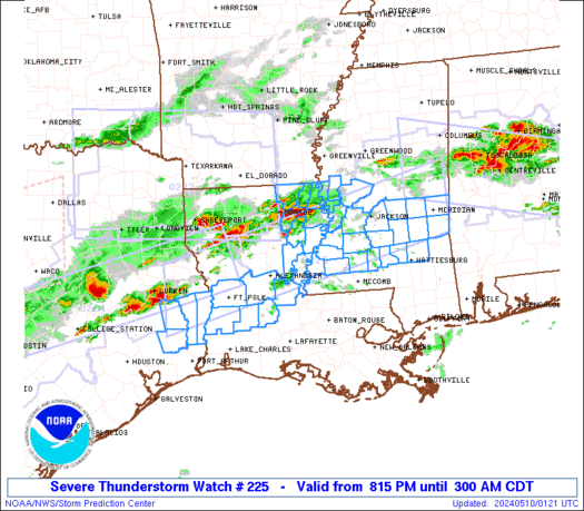
Severe Thunderstorm Watch Number 225
NWS Storm Prediction Center Norman OK
815 PM CDT Thu May 9 2024
The NWS Storm Prediction Center has issued a
* Severe Thunderstorm Watch for portions of
Central Louisiana
Central Mississippi
Southeast Texas
* Effective this Thursday night and Friday morning from 815 PM
until 300 AM CDT.
* Primary threats include…
Scattered damaging winds and isolated significant gusts to 75
mph likely
Scattered large hail and isolated very large hail events to 2
inches in diameter likely
A tornado or two possible
SUMMARY…Thunderstorms over East Texas and northern Louisiana will
develop eastward through the evening across the watch area, large
hail is possible early, with an increasing risk of damaging winds as
storms organize into lines.
The severe thunderstorm watch area is approximately along and 45
statute miles north and south of a line from 80 miles west of Fort
Polk LA to 25 miles northeast of Meridian MS. For a complete
depiction of the watch see the associated watch outline update
(WOUS64 KWNS WOU5).
PRECAUTIONARY/PREPAREDNESS ACTIONS…
REMEMBER…A Severe Thunderstorm Watch means conditions are
favorable for severe thunderstorms in and close to the watch area.
Persons in these areas should be on the lookout for threatening
weather conditions and listen for later statements and possible
warnings. Severe thunderstorms can and occasionally do produce
tornadoes.
&&
OTHER WATCH INFORMATION…CONTINUE…WW 221…WW 222…WW
223…WW 224…
AVIATION…A few severe thunderstorms with hail surface and aloft to
2 inches. Extreme turbulence and surface wind gusts to 65 knots. A
few cumulonimbi with maximum tops to 500. Mean storm motion vector
27035.
…Hart