
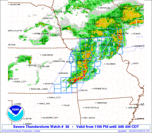
WW 38 SEVERE TSTM IA IL KS MO 140400Z – 141100Z
URGENT – IMMEDIATE BROADCAST REQUESTED
Severe Thunderstorm Watch Number 38
NWS Storm Prediction Center Norman OK
1100 PM CDT Wed Mar 13 2024
The NWS Storm Prediction Center has issued a
* Severe Thunderstorm Watch for portions of
Southeast Iowa
West Central Illinois
Southeast Kansas
Northern and Central Missouri
* Effective this Wednesday night and Thursday morning from 1100
PM until 600 AM CDT.
* Primary threats include…
Scattered large hail and isolated very large hail events to 2
inches in diameter likely
Scattered damaging wind gusts to 65 mph possible
A tornado or two possible
SUMMARY…Scattered intense storms will continue to affect parts of
northern Missouri, while new storms develop over southeast Kansas
and spread eastward across the watch area. Large hail appears to be
the primary risk overnight.
The severe thunderstorm watch area is approximately along and 70
statute miles east and west of a line from 45 miles south southwest
of Chanute KS to 35 miles north northwest of Kirksville MO. For a
complete depiction of the watch see the associated watch outline
update (WOUS64 KWNS WOU8).
PRECAUTIONARY/PREPAREDNESS ACTIONS…
REMEMBER…A Severe Thunderstorm Watch means conditions are
favorable for severe thunderstorms in and close to the watch area.
Persons in these areas should be on the lookout for threatening
weather conditions and listen for later statements and possible
warnings. Severe thunderstorms can and occasionally do produce
tornadoes.
&&
OTHER WATCH INFORMATION…CONTINUE…WW 35…WW 36…WW 37…
AVIATION…A few severe thunderstorms with hail surface and aloft to
2 inches. Extreme turbulence and surface wind gusts to 55 knots. A
few cumulonimbi with maximum tops to 450. Mean storm motion vector
25030.
…Hart