
WW 154 TORNADO IL MO 280240Z – 280900Z
URGENT – IMMEDIATE BROADCAST REQUESTED
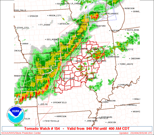
Tornado Watch Number 154
NWS Storm Prediction Center Norman OK
940 PM CDT Sat Apr 27 2024
The NWS Storm Prediction Center has issued a
* Tornado Watch for portions of
Central and Western Illinois
Central and Eastern Missouri
* Effective this Saturday night and Sunday morning from 940 PM
until 400 AM CDT.
* Primary threats include…
A couple tornadoes possible
Scattered damaging wind gusts to 70 mph likely
Scattered large hail events to 1.5 inches in diameter possible
SUMMARY…An severe squall line will move from west to east across
much of the Watch area during the late evening into the overnight.
A few storms may also develop ahead of the line and also pose a
severe risk. Tornadoes and damaging gusts will be the primary
severe hazards.
The tornado watch area is approximately along and 70 statute miles
east and west of a line from 35 miles northeast of Peoria IL to 15
miles west of Vichy MO. For a complete depiction of the watch see
the associated watch outline update (WOUS64 KWNS WOU4).
PRECAUTIONARY/PREPAREDNESS ACTIONS…
REMEMBER…A Tornado Watch means conditions are favorable for
tornadoes and severe thunderstorms in and close to the watch
area. Persons in these areas should be on the lookout for
threatening weather conditions and listen for later statements
and possible warnings.
&&
OTHER WATCH INFORMATION…CONTINUE…WW 149…WW 150…WW
151…WW 152…WW 153…
AVIATION…Tornadoes and a few severe thunderstorms with hail
surface and aloft to 1.5 inches. Extreme turbulence and surface wind
gusts to 60 knots. A few cumulonimbi with maximum tops to 500. Mean
storm motion vector 24035.
…Smith