
WW 33 TORNADO AL FL GA CW 090805Z – 091600Z
URGENT – IMMEDIATE BROADCAST REQUESTED
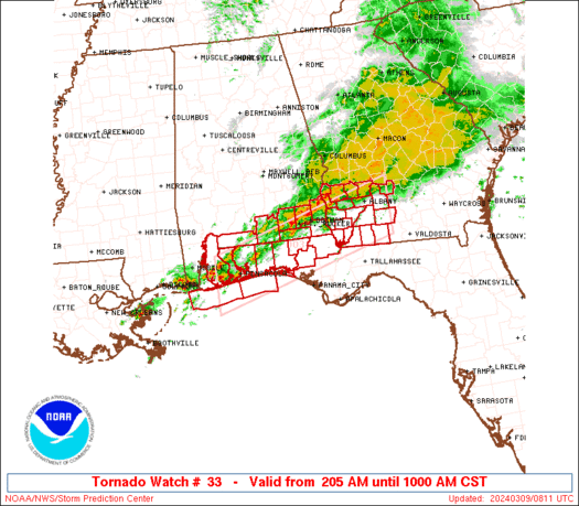
Tornado Watch Number 33
NWS Storm Prediction Center Norman OK
205 AM CST Sat Mar 9 2024
The NWS Storm Prediction Center has issued a
* Tornado Watch for portions of
Southern Alabama
Florida Panhandle
Southwestern Georgia
Coastal Waters
* Effective this Saturday morning from 205 AM until 1000 AM CST.
* Primary threats include…
A couple intense tornadoes possible
Scattered damaging wind gusts to 70 mph possible
Isolated large hail events to 1.5 inches in diameter possible
SUMMARY…A band of thunderstorms will continue shifting slowly
eastward over the watch area through the remainder of the morning,
as embedded strong-severe thunderstorms move rapidly along its axis.
The environment has become and will remain favorable for
occasional, embedded, potentially tornadic circulations.
The tornado watch area is approximately along and 40 statute miles
north and south of a line from 35 miles west southwest of Pensacola
FL to 25 miles north northeast of Moultrie GA. For a complete
depiction of the watch see the associated watch outline update
(WOUS64 KWNS WOU3).
PRECAUTIONARY/PREPAREDNESS ACTIONS…
REMEMBER…A Tornado Watch means conditions are favorable for
tornadoes and severe thunderstorms in and close to the watch
area. Persons in these areas should be on the lookout for
threatening weather conditions and listen for later statements
and possible warnings.
&&
AVIATION…Tornadoes and a few severe thunderstorms with hail
surface and aloft to 1.5 inches. Extreme turbulence and surface wind
gusts to 60 knots. A few cumulonimbi with maximum tops to 450. Mean
storm motion vector 24040.
…Edwards