
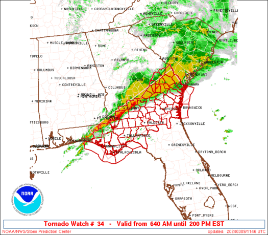
WW 34 TORNADO FL GA CW 091140Z – 091900Z
URGENT – IMMEDIATE BROADCAST REQUESTED
Tornado Watch Number 34
NWS Storm Prediction Center Norman OK
640 AM EST Sat Mar 9 2024
The NWS Storm Prediction Center has issued a
* Tornado Watch for portions of
Central and eastern Florida Panhandle
Southern Georgia
Coastal Waters
* Effective this Saturday morning and afternoon from 640 AM until
200 PM EST.
* Primary threats include…
A few tornadoes possible
Scattered damaging wind gusts to 70 mph possible
Isolated large hail events to 1.5 inches in diameter possible
SUMMARY…A band of strong to occasionally severe thunderstorms will
shift eastward across the watch area through midday, in a
destabilizing environment, while embedded cells pose a threat for
damaging to severe gusts and a few tornadoes.
The tornado watch area is approximately along and 50 statute miles
either side of a line from 5 miles south of Panama City FL to 5
miles northeast of Savannah GA. For a complete depiction of the
watch see the associated watch outline update (WOUS64 KWNS WOU4).
PRECAUTIONARY/PREPAREDNESS ACTIONS…
REMEMBER…A Tornado Watch means conditions are favorable for
tornadoes and severe thunderstorms in and close to the watch
area. Persons in these areas should be on the lookout for
threatening weather conditions and listen for later statements
and possible warnings.
&&
OTHER WATCH INFORMATION…This tornado watch replaces tornado
watch number 33. Watch number 33 will not be in effect after 640
AM EST.
AVIATION…Tornadoes and a few severe thunderstorms with hail
surface and aloft to 1.5 inches. Extreme turbulence and surface wind
gusts to 60 knots. A few cumulonimbi with maximum tops to 450. Mean
storm motion vector 24040.
…Edwards