
Apple’s annual iPhone event is coming up quickly, and things are starting to firm up regarding what we might see and when. Beyond the iPhone and other updates expected next month, we’re also looking toward some Mac updates later in the year while Apple appears to be moving forward on its tabletop robot project, so …
Continue reading Top Stories: September 10 iPhone Event Expected, 2024 Mac Updates, and More
Month:August 2024
SPC Severe Thunderstorm Watch 645 Status Reports

WW 0645 Status Updates STATUS REPORT ON WW 645 SEVERE WEATHER THREAT CONTINUES RIGHT OF A LINE FROM 15 NNW LVM TO 25 SSW GTF TO 45 SSW CTB TO 40 SE GPI TO 35 SSW GPI. ..SPC..08/24/24 ATTN…WFO…TFX…MSO… STATUS REPORT FOR WS 645 SEVERE WEATHER THREAT CONTINUES FOR THE FOLLOWING AREAS MTC005-013-015-027-029-035-041-045-051-053-059-073-099-101- 240140- MT …
Continue reading SPC Severe Thunderstorm Watch 645 Status Reports
SPC Severe Thunderstorm Watch 645
WW 645 SEVERE TSTM MT 232055Z – 240300Z URGENT – IMMEDIATE BROADCAST REQUESTED Severe Thunderstorm Watch Number 645 NWS Storm Prediction Center Norman OK 255 PM MDT Fri Aug 23 2024 The NWS Storm Prediction Center has issued a * Severe Thunderstorm Watch for portions of Western and Central Montana * Effective this Friday afternoon …
Continue reading SPC Severe Thunderstorm Watch 645
SPC MD 1981
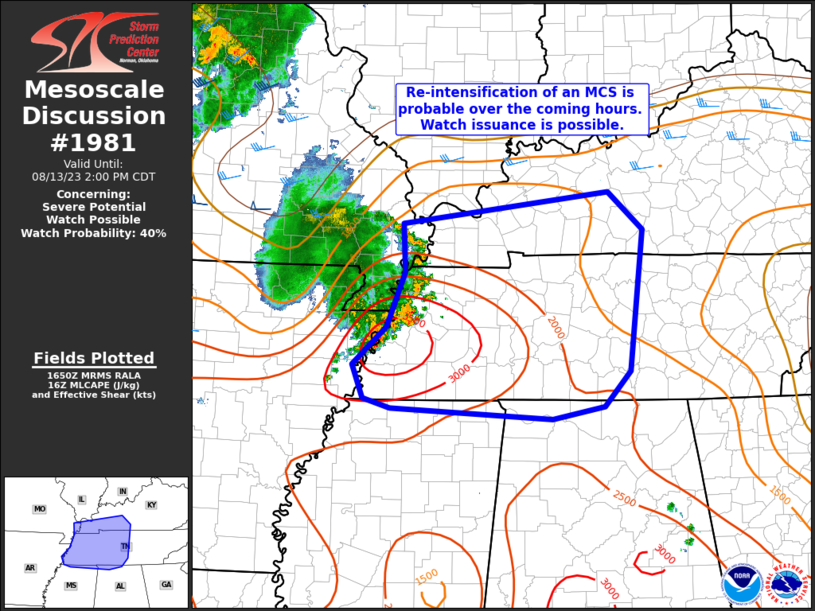
MD 1981 CONCERNING SEVERE POTENTIAL…WATCH UNLIKELY FOR EASTERN MONTANA Mesoscale Discussion 1981 NWS Storm Prediction Center Norman OK 0539 PM CDT Fri Aug 23 2024 Areas affected…Eastern Montana Concerning…Severe potential…Watch unlikely Valid 232239Z – 240045Z Probability of Watch Issuance…20 percent SUMMARY…Isolated threat for wind/hail will be noted with convection this evening. Watch is not currently …
Continue reading SPC MD 1981
SPC MD 1982

MD 1982 CONCERNING SEVERE POTENTIAL…WATCH UNLIKELY FOR PORTIONS OF NORTHEAST COLORADO…FAR SOUTHEAST WYOMING…AND WESTERN NEBRASKA Mesoscale Discussion 1982 NWS Storm Prediction Center Norman OK 0553 PM CDT Fri Aug 23 2024 Areas affected…Portions of northeast Colorado…far southeast Wyoming…and western Nebraska Concerning…Severe potential…Watch unlikely Valid 232253Z – 240030Z Probability of Watch Issuance…20 percent SUMMARY…Storms may consolidate …
Continue reading SPC MD 1982
SPC MD 1983
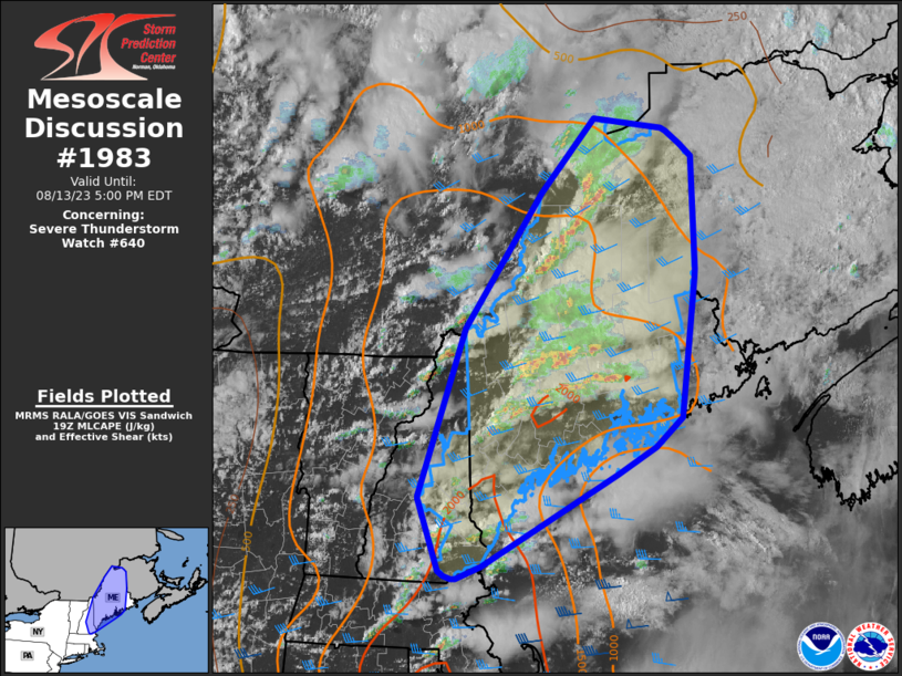
MD 1983 CONCERNING SEVERE THUNDERSTORM WATCH 645… FOR WESTERN MONTANA Mesoscale Discussion 1983 NWS Storm Prediction Center Norman OK 0604 PM CDT Fri Aug 23 2024 Areas affected…Western Montana Concerning…Severe Thunderstorm Watch 645… Valid 232304Z – 240100Z The severe weather threat for Severe Thunderstorm Watch 645 continues. SUMMARY…Severe wind gust potential continues with convection this …
Continue reading SPC MD 1983
SPC MD 1980
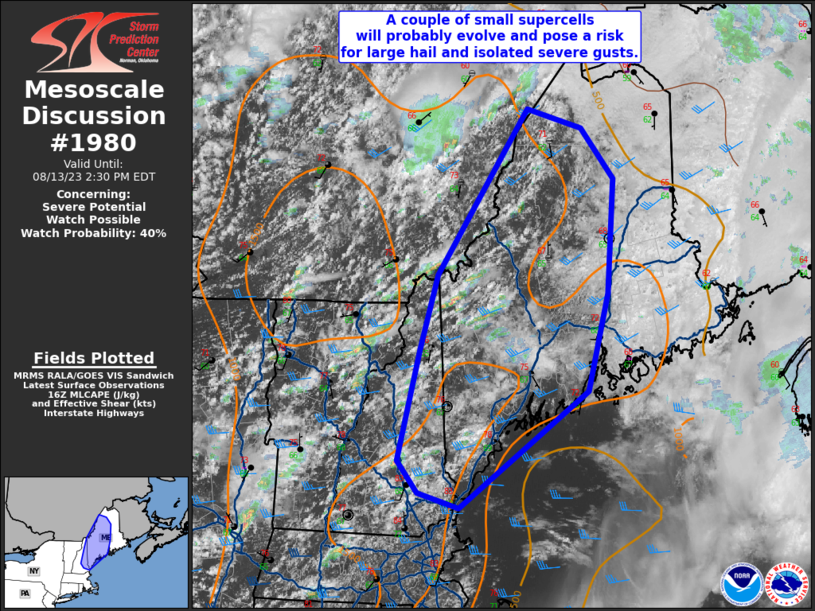
MD 1980 CONCERNING SEVERE POTENTIAL…WATCH UNLIKELY FOR WESTERN KANSAS…FAR EASTERN COLORADO…THE OK/TX PANHANDLES AND NORTHWEST OKLAHOMA Mesoscale Discussion 1980 NWS Storm Prediction Center Norman OK 0515 PM CDT Fri Aug 23 2024 Areas affected…Western Kansas…far Eastern Colorado…the OK/TX Panhandles and Northwest Oklahoma Concerning…Severe potential…Watch unlikely Valid 232215Z – 232345Z Probability of Watch Issuance…5 percent SUMMARY…A …
Continue reading SPC MD 1980
iOS 18 Notes App: All the New Features
With iOS 18, the Notes app is set to gain several new features. There aren’t many updates to the overall design, but Notes has deeper integrations with other apps that add all kinds of new functionality. There are also a few nifty iPad-only Notes features that involve the Apple Pencil. Math Notes Notes integrates with …
Continue reading iOS 18 Notes App: All the New Features
SPC MD 1979
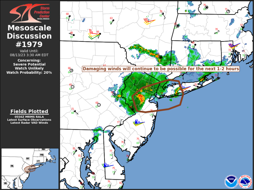
MD 1979 CONCERNING SEVERE POTENTIAL…WATCH UNLIKELY FOR PORTIONS OF SOUTHERN/EASTERN UTAH INTO FAR WESTERN COLORADO Mesoscale Discussion 1979 NWS Storm Prediction Center Norman OK 0353 PM CDT Fri Aug 23 2024 Areas affected…Portions of southern/eastern Utah into far western Colorado Concerning…Severe potential…Watch unlikely Valid 232053Z – 232300Z Probability of Watch Issuance…20 percent SUMMARY…Scattered storms, some …
Continue reading SPC MD 1979
SPC MD 1977

MD 1977 CONCERNING SEVERE POTENTIAL…WATCH UNLIKELY FOR SOUTHEASTERN ARIZONA AND FAR SOUTHWESTERN NEW MEXICO Mesoscale Discussion 1977 NWS Storm Prediction Center Norman OK 0222 PM CDT Fri Aug 23 2024 Areas affected…Southeastern Arizona and far southwestern New Mexico Concerning…Severe potential…Watch unlikely Valid 231922Z – 232115Z Probability of Watch Issuance…5 percent SUMMARY…Severe wind gusts and isolated …
Continue reading SPC MD 1977