
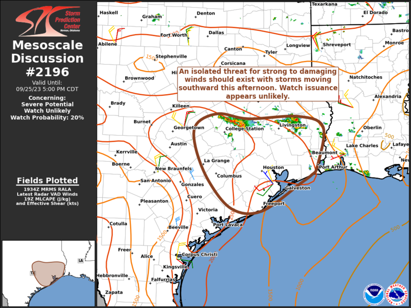
MD 2198 CONCERNING SEVERE POTENTIAL…WATCH UNLIKELY FOR PORTIONS OF CENTRAL/SOUTHERN ALABAMA Mesoscale Discussion 2198 NWS Storm Prediction Center Norman OK 0300 PM CST Fri Nov 07 2025 Areas affected…portions of central/southern Alabama Concerning…Severe potential…Watch unlikely Valid 072100Z – 072300Z Probability of Watch Issuance…20 percent SUMMARY…Isolated strong to locally severe thunderstorms may develop over the next …
Continue reading SPC MD 2198
Category:Weather
SPC MD 2197
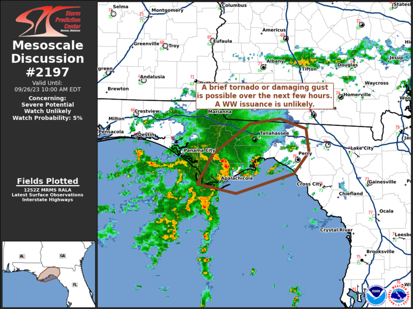
MD 2197 CONCERNING SEVERE POTENTIAL…WATCH POSSIBLE FOR PARTS OF MIDDLE TN…SOUTH-CENTRAL KY…FAR NORTHERN AL Mesoscale Discussion 2197 NWS Storm Prediction Center Norman OK 0210 PM CST Fri Nov 07 2025 Areas affected…Parts of Middle TN…south-central KY…far northern AL Concerning…Severe potential…Watch possible Valid 072010Z – 072215Z Probability of Watch Issuance…60 percent SUMMARY…The severe-storm threat is expected …
Continue reading SPC MD 2197
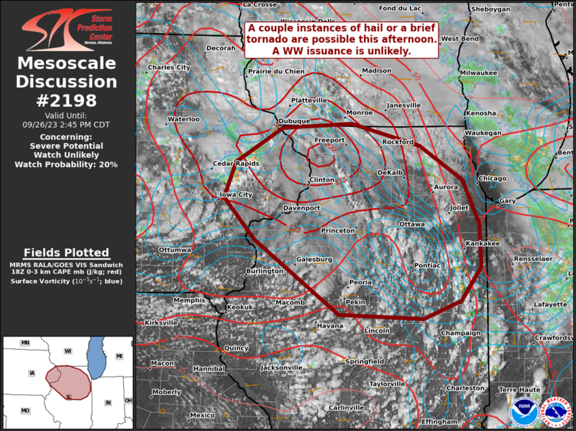
SPC MD 2196
MD 2196 CONCERNING SEVERE POTENTIAL…WATCH UNLIKELY FOR COASTAL OREGON Mesoscale Discussion 2196 NWS Storm Prediction Center Norman OK 0209 PM CST Wed Nov 05 2025 Areas affected…Coastal Oregon Concerning…Severe potential…Watch unlikely Valid 052009Z – 052215Z Probability of Watch Issuance…20 percent SUMMARY…Isolated to widely-scattered low-topped storms are expected to move onshore over the next few hours. …
Continue reading SPC MD 2196
SPC Nov 2, 2025 0600 UTC Day 2 Convective Outlook

SPC 0600Z Day 2 Outlook Day 2 Convective Outlook NWS Storm Prediction Center Norman OK 1252 AM CDT Sun Nov 02 2025 Valid 031200Z – 041200Z …NO THUNDERSTORM AREAS FORECAST… …SUMMARY… No severe threat is expected across the continental U.S. on Monday and Monday night. …DISCUSSION… A mid-level low will move from central South Carolina …
Continue reading SPC Nov 2, 2025 0600 UTC Day 2 Convective Outlook
SPC MD 2195
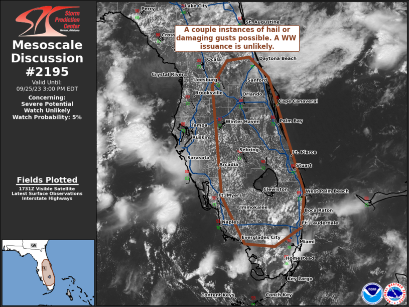
MD 2195 CONCERNING SEVERE POTENTIAL…WATCH POSSIBLE FOR PARTS OF FAR SOUTHERN TEXAS INCLUDING THE MIDDLE AND LOWER COASTAL COUNTIES Mesoscale Discussion 2195 NWS Storm Prediction Center Norman OK 0523 PM CDT Sat Nov 01 2025 Areas affected…parts of far southern Texas including the middle and lower coastal counties Concerning…Severe potential…Watch possible Valid 012223Z – 020130Z …
Continue reading SPC MD 2195
SPC Nov 1, 2025 0730 UTC Day 3 Severe Thunderstorm Outlook

SPC 0730Z Day 3 Outlook Day 3 Convective Outlook NWS Storm Prediction Center Norman OK 0229 AM CDT Sat Nov 01 2025 Valid 031200Z – 041200Z …NO SEVERE THUNDERSTORM AREAS FORECAST… …SUMMARY… No severe threat is expected across the continental U.S. on Monday and Monday night. …DISCUSSION… A mid-level low is forecast to move across …
Continue reading SPC Nov 1, 2025 0730 UTC Day 3 Severe Thunderstorm Outlook
SPC MD 2194

MD 2194 CONCERNING SEVERE POTENTIAL…WATCH UNLIKELY FOR SOUTHEAST PENNSYLVANIA…SOUTHERN NEW JERSEY…NORTHERN DELMARVA Mesoscale Discussion 2194 NWS Storm Prediction Center Norman OK 0216 PM CDT Thu Oct 30 2025 Areas affected…southeast Pennsylvania…southern New Jersey…northern DelMarVa Concerning…Severe potential…Watch unlikely Valid 301916Z – 302115Z Probability of Watch Issuance…5 percent SUMMARY…An isolated strong storm or two may develop over …
Continue reading SPC MD 2194
SPC Tornado Watch 634 Status Reports
WW 0634 Status Updates STATUS REPORT ON WW 634 SEVERE WEATHER THREAT CONTINUES RIGHT OF A LINE FROM 35 WNW BPT TO 30 NNW IER TO 35 SSW MLU. ..KERR..10/28/25 ATTN…WFO…LCH…SHV…HGX… STATUS REPORT FOR WT 634 SEVERE WEATHER THREAT CONTINUES FOR THE FOLLOWING AREAS LAC003-011-019-021-039-043-053-059-069-079-081-115-127-290040- LA . LOUISIANA PARISHES INCLUDED ARE ALLEN BEAUREGARD CALCASIEU CALDWELL …
Continue reading SPC Tornado Watch 634 Status Reports
SPC Tornado Watch 634
WW 634 TORNADO LA TX CW 282045Z – 290300Z URGENT – IMMEDIATE BROADCAST REQUESTED Tornado Watch Number 634 NWS Storm Prediction Center Norman OK 345 PM CDT Tue Oct 28 2025 The NWS Storm Prediction Center has issued a * Tornado Watch for portions of Western Louisiana East-central and Southeast Texas Coastal Waters * Effective …
Continue reading SPC Tornado Watch 634
SPC MD 2193

MD 2193 CONCERNING TORNADO WATCH 634… FOR PARTS OF SOUTHEASTERN TEXAS INTO CENTRAL AND SOUTHWESTERN LOUISIANA Mesoscale Discussion 2193 NWS Storm Prediction Center Norman OK 0521 PM CDT Tue Oct 28 2025 Areas affected…parts of southeastern Texas into central and southwestern Louisiana Concerning…Tornado Watch 634… Valid 282221Z – 290015Z The severe weather threat for Tornado …
Continue reading SPC MD 2193