
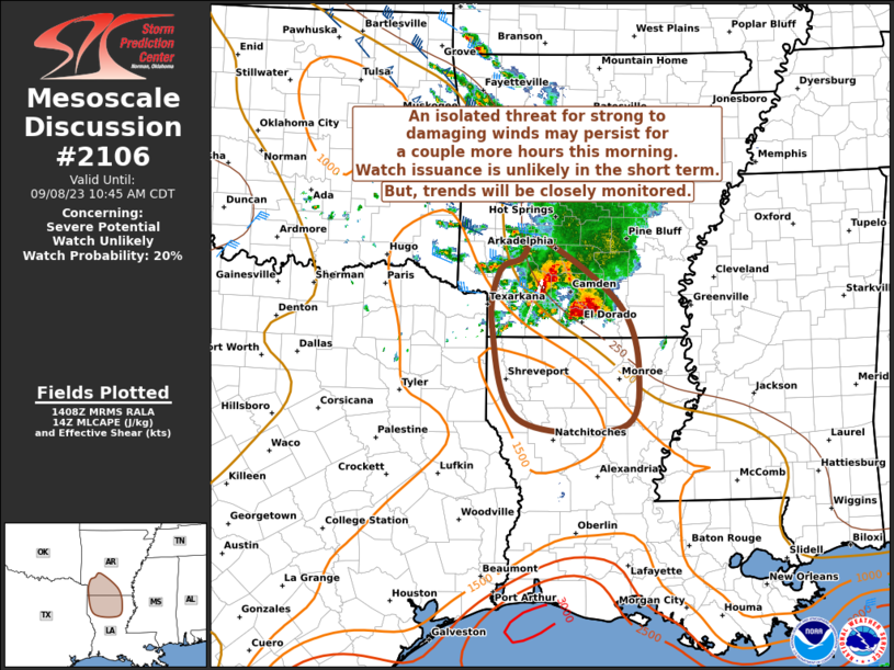
MD 2106 CONCERNING SEVERE POTENTIAL…WATCH UNLIKELY FOR EASTERN TEXAS AND OKLAHOMA PANHANDLES INTO WESTERN OKLAHOMA Mesoscale Discussion 2106 NWS Storm Prediction Center Norman OK 0239 PM CDT Sat Sep 20 2025 Areas affected…Eastern Texas and Oklahoma Panhandles into western Oklahoma Concerning…Severe potential…Watch unlikely Valid 201939Z – 202215Z Probability of Watch Issuance…5 percent SUMMARY…Scattered strong storms …
Continue reading SPC MD 2106
Category:Weather
SPC MD 2105

MD 2105 CONCERNING SEVERE THUNDERSTORM WATCH 615… FOR SOUTH-CENTRAL KANSAS Mesoscale Discussion 2105 NWS Storm Prediction Center Norman OK 1043 PM CDT Fri Sep 19 2025 Areas affected…South-central Kansas Concerning…Severe Thunderstorm Watch 615… Valid 200343Z – 200445Z The severe weather threat for Severe Thunderstorm Watch 615 continues. SUMMARY…Strong to intermittently severe convection will persist as …
Continue reading SPC MD 2105
SPC MD 2104
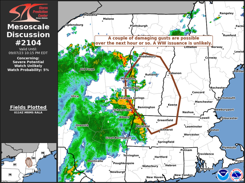
MD 2104 CONCERNING SEVERE THUNDERSTORM WATCH 615… FOR CENTRAL AND SOUTH CENTRAL KANSAS Mesoscale Discussion 2104 NWS Storm Prediction Center Norman OK 0850 PM CDT Fri Sep 19 2025 Areas affected…Central and South Central Kansas Concerning…Severe Thunderstorm Watch 615… Valid 200150Z – 200345Z The severe weather threat for Severe Thunderstorm Watch 615 continues. SUMMARY…Severe thunderstorms …
Continue reading SPC MD 2104
SPC Severe Thunderstorm Watch 615 Status Reports

WW 0615 Status Updates STATUS REPORT ON WW 615 SEVERE WEATHER THREAT CONTINUES RIGHT OF A LINE FROM 50 SSW HLC TO 15 SSE RSL TO 30 SSE RSL TO 35 NNE ICT. FOR ADDITIONAL INFORMATION SEE MESOSCALE DISCUSSION 2104 ..HALBERT..09/20/25 ATTN…WFO…ICT…DDC… STATUS REPORT FOR WS 615 SEVERE WEATHER THREAT CONTINUES FOR THE FOLLOWING AREAS …
Continue reading SPC Severe Thunderstorm Watch 615 Status Reports
SPC MD 2103
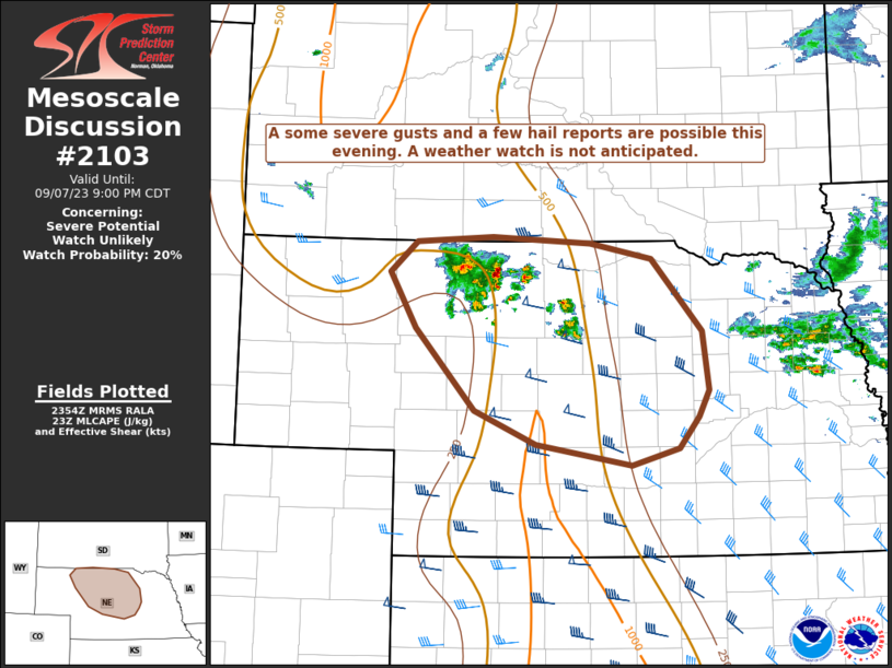
MD 2103 CONCERNING SEVERE POTENTIAL…WATCH POSSIBLE FOR NORTHERN AND CENTRAL KANSAS Mesoscale Discussion 2103 NWS Storm Prediction Center Norman OK 0532 PM CDT Fri Sep 19 2025 Areas affected…Northern and Central Kansas Concerning…Severe potential…Watch possible Valid 192232Z – 200030Z Probability of Watch Issuance…60 percent SUMMARY…A pair of supercells across portions of northern Kansas continue generally …
Continue reading SPC MD 2103
SPC Severe Thunderstorm Watch 615
WW 615 SEVERE TSTM KS 192250Z – 200400Z URGENT – IMMEDIATE BROADCAST REQUESTED Severe Thunderstorm Watch Number 615 NWS Storm Prediction Center Norman OK 550 PM CDT Fri Sep 19 2025 The NWS Storm Prediction Center has issued a * Severe Thunderstorm Watch for portions of Central Kansas * Effective this Friday afternoon and evening …
Continue reading SPC Severe Thunderstorm Watch 615
SPC MD 2102

MD 2102 CONCERNING SEVERE POTENTIAL…WATCH UNLIKELY FOR CENTRAL AND WESTERN WISCONSIN Mesoscale Discussion 2102 NWS Storm Prediction Center Norman OK 0446 PM CDT Fri Sep 19 2025 Areas affected…Central and Western Wisconsin Concerning…Severe potential…Watch unlikely Valid 192146Z – 192345Z Probability of Watch Issuance…20 percent SUMMARY…A cluster of thunderstorms north of a surface warm front will …
Continue reading SPC MD 2102
SPC MD 2101

MD 2101 CONCERNING SEVERE POTENTIAL…WATCH UNLIKELY FOR EXTREME SOUTHERN NEBRASKA INTO MUCH OF NORTHWEST/NORTH-CENTRAL KANSAS Mesoscale Discussion 2101 NWS Storm Prediction Center Norman OK 0309 PM CDT Fri Sep 19 2025 Areas affected…extreme southern Nebraska into much of northwest/north-central Kansas Concerning…Severe potential…Watch unlikely Valid 192009Z – 192245Z Probability of Watch Issuance…20 percent SUMMARY…Storms are expected …
Continue reading SPC MD 2101
SPC MD 2100

MD 2100 CONCERNING SEVERE THUNDERSTORM WATCH 614… FOR MISSOURI Mesoscale Discussion 2100 NWS Storm Prediction Center Norman OK 0843 PM CDT Thu Sep 18 2025 Areas affected…Missouri Concerning…Severe Thunderstorm Watch 614… Valid 190143Z – 190315Z The severe weather threat for Severe Thunderstorm Watch 614 continues. SUMMARY…Severe threat is decreasing across Missouri this evening. Even so, …
Continue reading SPC MD 2100
SPC Severe Thunderstorm Watch 614 Status Reports

WW 0614 Status Updates STATUS REPORT ON WW 614 SEVERE WEATHER THREAT CONTINUES RIGHT OF A LINE FROM 15 N FLP TO 35 SW TBN TO 40 NW TBN TO 25 WSW JEF TO 25 WNW COU TO 45 SSW IRK. ..HALBERT..09/19/25 ATTN…WFO…LSX…SGF…EAX… STATUS REPORT FOR WS 614 SEVERE WEATHER THREAT CONTINUES FOR THE FOLLOWING …
Continue reading SPC Severe Thunderstorm Watch 614 Status Reports