
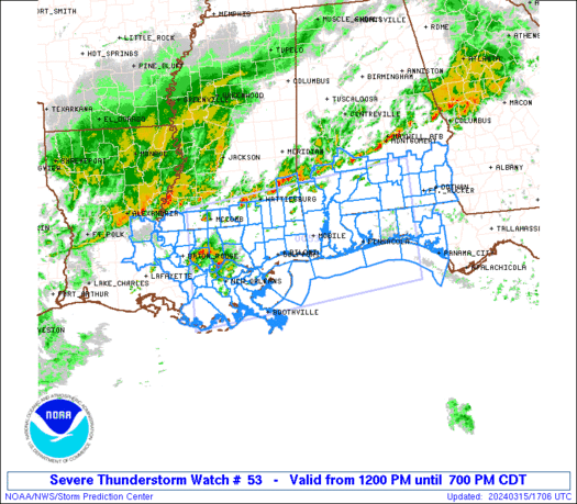
WW 0053 Status Updates STATUS REPORT ON WW 53 SEVERE WEATHER THREAT CONTINUES RIGHT OF A LINE FROM 20 N SSU TO 10 ESE MGW TO 15 NNW ERI. ..LYONS..03/16/25 ATTN…WFO…CLE…RLX…PBZ… STATUS REPORT FOR WT 53 SEVERE WEATHER THREAT CONTINUES FOR THE FOLLOWING AREAS PAC005-031-039-049-053-063-065-121-161940- PA . PENNSYLVANIA COUNTIES INCLUDED ARE ARMSTRONG CLARION CRAWFORD ERIE …
Continue reading SPC Tornado Watch 53 Status Reports
Category:Weather
SPC MD 231
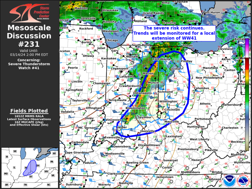
MD 0231 CONCERNING TORNADO WATCH 54… FOR CENTRAL PENNSYLVANIA Mesoscale Discussion 0231 NWS Storm Prediction Center Norman OK 0107 PM CDT Sun Mar 16 2025 Areas affected…central Pennsylvania Concerning…Tornado Watch 54… Valid 161807Z – 161900Z The severe weather threat for Tornado Watch 54 continues. SUMMARY…A line of storms producing damaging winds continues to move rapidly …
Continue reading SPC MD 231
SPC Severe Thunderstorm Watch 55
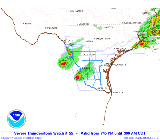
WW 55 SEVERE TSTM NY LE LO 161735Z – 162300Z URGENT – IMMEDIATE BROADCAST REQUESTED Severe Thunderstorm Watch Number 55 NWS Storm Prediction Center Norman OK 135 PM EDT Sun Mar 16 2025 The NWS Storm Prediction Center has issued a * Severe Thunderstorm Watch for portions of Western New York Lake Erie Lake Ontario …
Continue reading SPC Severe Thunderstorm Watch 55
SPC MD 229

MD 0229 CONCERNING TORNADO WATCH 51… FOR PORTIONS OF THE EASTERN CAROLINAS Mesoscale Discussion 0229 NWS Storm Prediction Center Norman OK 1213 PM CDT Sun Mar 16 2025 Areas affected…portions of the eastern Carolinas Concerning…Tornado Watch 51… Valid 161713Z – 161845Z The severe weather threat for Tornado Watch 51 continues. SUMMARY…The severe threat continues across …
Continue reading SPC MD 229
SPC Tornado Watch 51 Status Reports
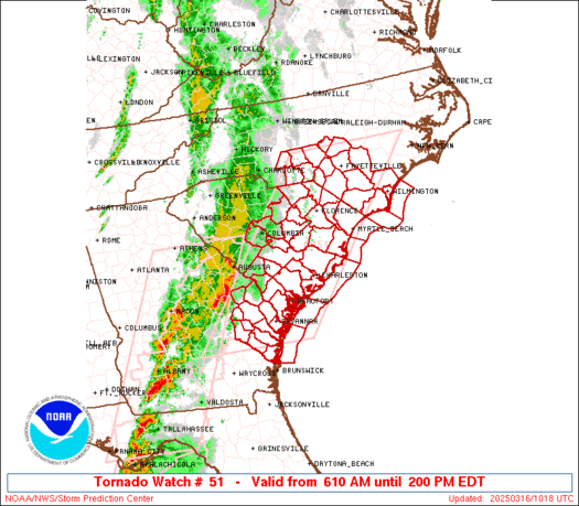
WW 0051 Status Updates STATUS REPORT ON WW 51 SEVERE WEATHER THREAT CONTINUES RIGHT OF A LINE FROM 40 NE AYS TO 20 SSW FLO TO 10 SSW FAY TO 10 SW RDU. ..LYONS..03/16/25 ATTN…WFO…CHS…RAH…ILM…CAE… STATUS REPORT FOR WT 51 SEVERE WEATHER THREAT CONTINUES FOR THE FOLLOWING AREAS GAC029-051-179-191-161740- GA . GEORGIA COUNTIES INCLUDED ARE …
Continue reading SPC Tornado Watch 51 Status Reports
SPC Tornado Watch 54
WW 54 TORNADO MD PA VA WV 161650Z – 162300Z URGENT – IMMEDIATE BROADCAST REQUESTED Tornado Watch Number 54 NWS Storm Prediction Center Norman OK 1250 PM EDT Sun Mar 16 2025 The NWS Storm Prediction Center has issued a * Tornado Watch for portions of Western Maryland Western and Central Pennsylvania Northern Virginia Eastern …
Continue reading SPC Tornado Watch 54
SPC MD 228

MD 0228 CONCERNING TORNADO WATCH 53… FOR WEST VIRGINIA…FAR WESTERN MARYLAND…WESTERN AND CENTRAL PENNSYLVANIA…AND FAR SOUTHWESTERN NEW YORK. Mesoscale Discussion 0228 NWS Storm Prediction Center Norman OK 1108 AM CDT Sun Mar 16 2025 Areas affected…West Virginia…far western Maryland…western and central Pennsylvania…and far southwestern New York. Concerning…Tornado Watch 53… Valid 161608Z – 161745Z The severe …
Continue reading SPC MD 228
SPC MD 227
MD 0227 CONCERNING TORNADO WATCH 52… FOR FAR SOUTHEASTERN GEORGIA INTO THE NORTHERN AND CENTRAL FLORIDA PENINSULA Mesoscale Discussion 0227 NWS Storm Prediction Center Norman OK 1039 AM CDT Sun Mar 16 2025 Areas affected…far southeastern Georgia into the northern and central Florida Peninsula Concerning…Tornado Watch 52… Valid 161539Z – 161715Z The severe weather threat …
Continue reading SPC MD 227
SPC MD 226

MD 0226 CONCERNING SEVERE POTENTIAL…WATCH UNLIKELY FOR SOUTH-CENTRAL INTO EASTERN KENTUCKY Mesoscale Discussion 0226 NWS Storm Prediction Center Norman OK 0938 AM CDT Sun Mar 16 2025 Areas affected…south-central into eastern Kentucky Concerning…Severe potential…Watch unlikely Valid 161438Z – 161615Z Probability of Watch Issuance…20 percent SUMMARY…Some damaging wind gusts are possible this morning to early afternoon …
Continue reading SPC MD 226
SPC Tornado Watch 53
WW 53 TORNADO OH PA WV 161430Z – 162000Z URGENT – IMMEDIATE BROADCAST REQUESTED Tornado Watch Number 53 NWS Storm Prediction Center Norman OK 1030 AM EDT Sun Mar 16 2025 The NWS Storm Prediction Center has issued a * Tornado Watch for portions of Eastern Ohio Western Pennsylvania West Virginia * Effective this Sunday …
Continue reading SPC Tornado Watch 53