

WW 32 TORNADO AR IL MO 142100Z – 150400Z URGENT – IMMEDIATE BROADCAST REQUESTED Tornado Watch Number 32 NWS Storm Prediction Center Norman OK 400 PM CDT Fri Mar 14 2025 The NWS Storm Prediction Center has issued a * Tornado Watch for portions of Northern Arkansas Western Illinois Central and Eastern Missouri * Effective …
Continue reading SPC Tornado Watch 32
Category:Weather
SPC Tornado Watch 33 Status Reports
WW 0033 Status Updates STATUS REPORT ON WW 33 THE SEVERE WEATHER THREAT CONTINUES ACROSS THE ENTIRE WATCH AREA. ..LYONS..03/14/25 ATTN…WFO…JAN…LCH…SHV…LIX… STATUS REPORT FOR WT 33 SEVERE WEATHER THREAT CONTINUES FOR THE FOLLOWING AREAS ARC003-017-142340- AR . ARKANSAS COUNTIES INCLUDED ARE ASHLEY CHICOT LAC003-009-021-025-029-033-035-037-039-041-043-049-059-063-065- 067-073-077-079-083-091-097-105-107-117-121-123-125-127- 142340- LA . LOUISIANA PARISHES INCLUDED ARE ALLEN AVOYELLES CALDWELL …
Continue reading SPC Tornado Watch 33 Status Reports
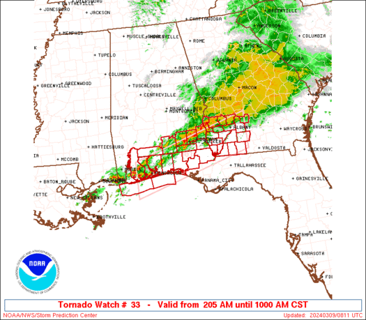
SPC Tornado Watch 33
WW 33 TORNADO AR LA MS 142200Z – 150300Z URGENT – IMMEDIATE BROADCAST REQUESTED Tornado Watch Number 33 NWS Storm Prediction Center Norman OK 500 PM CDT Fri Mar 14 2025 The NWS Storm Prediction Center has issued a * Tornado Watch for portions of Far Southeast Arkansas Eastern and Northeastern Louisiana Western and Southwestern …
Continue reading SPC Tornado Watch 33
SPC Severe Thunderstorm Watch 34
WW 34 SEVERE TSTM IA MN WI 142240Z – 150600Z URGENT – IMMEDIATE BROADCAST REQUESTED Severe Thunderstorm Watch Number 34 NWS Storm Prediction Center Norman OK 540 PM CDT Fri Mar 14 2025 The NWS Storm Prediction Center has issued a * Severe Thunderstorm Watch for portions of Northern Iowa South-Central and Southeast Minnesota Far …
Continue reading SPC Severe Thunderstorm Watch 34
SPC Severe Thunderstorm Watch 35

WW 35 SEVERE TSTM IA IL MO LM 142355Z – 150700Z URGENT – IMMEDIATE BROADCAST REQUESTED Severe Thunderstorm Watch Number 35 NWS Storm Prediction Center Norman OK 655 PM CDT Fri Mar 14 2025 The NWS Storm Prediction Center has issued a * Severe Thunderstorm Watch for portions of Eastern Iowa Northern Illinois Far Northeast …
Continue reading SPC Severe Thunderstorm Watch 35
SPC Severe Thunderstorm Watch 30 Status Reports
WW 0030 Status Updates STATUS REPORT ON WW 30 SEVERE WEATHER THREAT CONTINUES RIGHT OF A LINE FROM 25 SSW UMN TO 25 WNW SGF TO 35 S SZL TO 15 NW CDJ TO 30 ESE SDA. ..LYONS..03/14/25 ATTN…WFO…EAX…SGF…TOP… STATUS REPORT FOR WS 30 SEVERE WEATHER THREAT CONTINUES FOR THE FOLLOWING AREAS MOC009-057-061-081-109-209-227-142340- MO . …
Continue reading SPC Severe Thunderstorm Watch 30 Status Reports
SPC MD 173

MD 0173 CONCERNING SEVERE THUNDERSTORM WATCH 31… FOR EASTERN NEBRASKA…IOWA…SOUTHERN MINNESOTA…SOUTHWESTERN WISCONSIN…AND NORTHWESTERN ILLINOIS Mesoscale Discussion 0173 NWS Storm Prediction Center Norman OK 0501 PM CDT Fri Mar 14 2025 Areas affected…eastern Nebraska…Iowa…southern Minnesota…southwestern Wisconsin…and northwestern Illinois Concerning…Severe Thunderstorm Watch 31… Valid 142201Z – 142330Z The severe weather threat for Severe Thunderstorm Watch 31 continues. …
Continue reading SPC MD 173
SPC MD 172

MD 0172 CONCERNING SEVERE POTENTIAL…TORNADO WATCH LIKELY FOR EASTERN LOUISIANA INTO SOUTHWEST MISSISSIPPI Mesoscale Discussion 0172 NWS Storm Prediction Center Norman OK 0427 PM CDT Fri Mar 14 2025 Areas affected…Eastern Louisiana into southwest Mississippi Concerning…Severe potential…Tornado Watch likely Valid 142127Z – 142330Z Probability of Watch Issuance…80 percent SUMMARY…A tornado watch will likely be needed …
Continue reading SPC MD 172
SPC MD 171

MD 0171 CONCERNING SEVERE POTENTIAL…WATCH LIKELY FOR PARTS OF NORTHWESTERN AND NORTH CENTRAL ARKANSAS INTO CENTRAL MISSOURI Mesoscale Discussion 0171 NWS Storm Prediction Center Norman OK 0340 PM CDT Fri Mar 14 2025 Areas affected…parts of northwestern and north central Arkansas into central Missouri Concerning…Severe potential…Watch likely Valid 142040Z – 142245Z Probability of Watch Issuance…80 …
Continue reading SPC MD 171
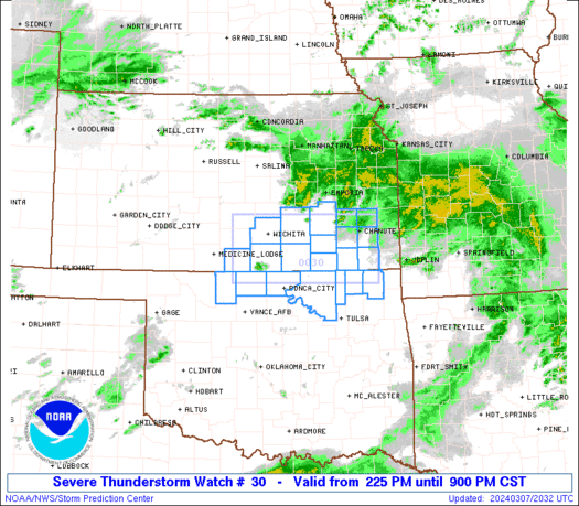
SPC Severe Thunderstorm Watch 30
WW 30 SEVERE TSTM KS MO 141915Z – 150000Z URGENT – IMMEDIATE BROADCAST REQUESTED Severe Thunderstorm Watch Number 30 NWS Storm Prediction Center Norman OK 215 PM CDT Fri Mar 14 2025 The NWS Storm Prediction Center has issued a * Severe Thunderstorm Watch for portions of Eastern Kansas Western Missouri * Effective this Friday …
Continue reading SPC Severe Thunderstorm Watch 30