
MD 0137 CONCERNING BLIZZARD FOR PORTIONS OF CENTRAL INTO EASTERN NEBRASKA Mesoscale Discussion 0137 NWS Storm Prediction Center Norman OK 0506 PM CST Tue Mar 04 2025 Areas affected…portions of central into eastern Nebraska Concerning…Blizzard Valid 042306Z – 050200Z SUMMARY…Blizzard conditions are possible over the next few hours. Moderate to heavy snowfall rates may occur …
Continue reading SPC MD 137
Category:Weather
SPC Tornado Watch 21
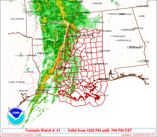
WW 21 TORNADO LA MS CW 041820Z – 050100Z URGENT – IMMEDIATE BROADCAST REQUESTED Tornado Watch Number 21 NWS Storm Prediction Center Norman OK 1220 PM CST Tue Mar 4 2025 The NWS Storm Prediction Center has issued a * Tornado Watch for portions of Eastern and Southeastern Louisiana Central and Southern Mississippi Coastal Waters …
Continue reading SPC Tornado Watch 21
SPC Tornado Watch 22
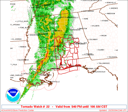
WW 22 TORNADO AL FL CW 042340Z – 050700Z URGENT – IMMEDIATE BROADCAST REQUESTED Tornado Watch Number 22 NWS Storm Prediction Center Norman OK 540 PM CST Tue Mar 4 2025 The NWS Storm Prediction Center has issued a * Tornado Watch for portions of Southern and South-Central Alabama Western Florida Panhandle Coastal Waters * …
Continue reading SPC Tornado Watch 22
SPC MD 136

MD 0136 CONCERNING SEVERE POTENTIAL…WATCH LIKELY FOR PORTIONS OF SOUTHERN ALABAMA AND THE FLORIDA PANHANDLE Mesoscale Discussion 0136 NWS Storm Prediction Center Norman OK 0402 PM CST Tue Mar 04 2025 Areas affected…portions of southern Alabama and the Florida panhandle Concerning…Severe potential…Watch likely Valid 042202Z – 042300Z Probability of Watch Issuance…80 percent SUMMARY…A downstream watch …
Continue reading SPC MD 136
SPC MD 135

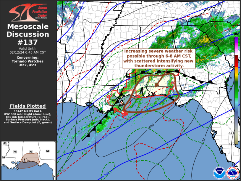
MD 0135 CONCERNING TORNADO WATCH 21… FOR SOUTHERN MISSISSIPPI AND SOUTHERN ALABAMA Mesoscale Discussion 0135 NWS Storm Prediction Center Norman OK 0214 PM CST Tue Mar 04 2025 Areas affected…southern Mississippi and southern Alabama Concerning…Tornado Watch 21… Valid 042014Z – 042145Z The severe weather threat for Tornado Watch 21 continues. SUMMARY…The greatest tornado threat this …
Continue reading SPC MD 135
SPC Tornado Watch 20 Status Reports
WW 0020 Status Updates STATUS REPORT ON WW 20 SEVERE WEATHER THREAT CONTINUES RIGHT OF A LINE FROM 30 NE LCH TO 20 S ESF. WW 20 WILL BE ALLOWED TO EXPIRE AT 042100Z. ..SUPINIE..03/04/25 ATTN…WFO…LZK…JAN…SHV…LCH… STATUS REPORT FOR WT 20 SEVERE WEATHER THREAT CONTINUES FOR THE FOLLOWING AREAS LAC001-023-039-053-113-042100- LA . LOUISIANA PARISHES INCLUDED …
Continue reading SPC Tornado Watch 20 Status Reports
SPC MD 134
MD 0134 CONCERNING SEVERE POTENTIAL…TORNADO WATCH LIKELY FOR MISSISSIPPI AND EASTERN LOUISIANA Mesoscale Discussion 0134 NWS Storm Prediction Center Norman OK 1149 AM CST Tue Mar 04 2025 Areas affected…Mississippi and eastern Louisiana Concerning…Severe potential…Tornado Watch likely Valid 041749Z – 041945Z Probability of Watch Issuance…95 percent SUMMARY…A downstream tornado watch will be needed soon. DISCUSSION…Low …
Continue reading SPC MD 134
SPC MD 133

MD 0133 CONCERNING HEAVY SNOW FOR EASTERN SOUTH DAKOTA INTO FAR SOUTHWESTERN MINNESOTA AND FAR NORTHERN NEBRASKA Mesoscale Discussion 0133 NWS Storm Prediction Center Norman OK 1025 AM CST Tue Mar 04 2025 Areas affected…Eastern South Dakota into far southwestern Minnesota and far northern Nebraska Concerning…Heavy snow Valid 041625Z – 042030Z SUMMARY…Localized moderate to heavy …
Continue reading SPC MD 133
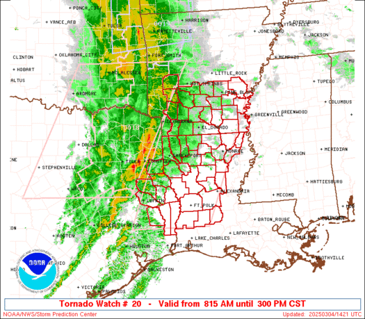
SPC MD 132

MD 0132 CONCERNING TORNADO WATCH 20… FOR SOUTHERN ARKANSAS…FAR EAST TEXAS…AND MUCH OF WESTERN LOUISIANA Mesoscale Discussion 0132 NWS Storm Prediction Center Norman OK 1017 AM CST Tue Mar 04 2025 Areas affected…southern Arkansas…far east Texas…and much of western Louisiana Concerning…Tornado Watch 20… Valid 041617Z – 041745Z The severe weather threat for Tornado Watch 20 …
Continue reading SPC MD 132
SPC Severe Thunderstorm Watch 19 Status Reports

WW 0019 Status Updates STATUS REPORT ON WW 19 SEVERE WEATHER THREAT CONTINUES RIGHT OF A LINE FROM 25 WNW FSM TO 5 SSE FYV TO 5 NNW HRO TO 20 NW FLP. ..BENTLEY..03/04/25 ATTN…WFO…TSA…LZK…SGF… STATUS REPORT FOR WS 19 SEVERE WEATHER THREAT CONTINUES FOR THE FOLLOWING AREAS ARC033-047-071-083-087-101-131-143-041640- AR . ARKANSAS COUNTIES INCLUDED ARE …
Continue reading SPC Severe Thunderstorm Watch 19 Status Reports