

WW 0715 Status Updates STATUS REPORT ON WW 715 SEVERE WEATHER THREAT CONTINUES RIGHT OF A LINE FROM 25 NNW LBX TO 25 NNW BPT TO 50 ENE LFK TO 25 N IER. ..THORNTON..12/27/24 ATTN…WFO…SHV…FWD…HGX…LCH… STATUS REPORT FOR WT 715 SEVERE WEATHER THREAT CONTINUES FOR THE FOLLOWING AREAS TXC039-071-167-270140- TX . TEXAS COUNTIES INCLUDED ARE …
Continue reading SPC Tornado Watch 715 Status Reports
Category:Weather
SPC Tornado Watch 716

WW 716 TORNADO LA TX CW 270010Z – 270800Z URGENT – IMMEDIATE BROADCAST REQUESTED Tornado Watch Number 716 NWS Storm Prediction Center Norman OK 610 PM CST Thu Dec 26 2024 The NWS Storm Prediction Center has issued a * Tornado Watch for portions of Western and Central Louisiana Far Southeast Texas Coastal Waters * …
Continue reading SPC Tornado Watch 716
SPC Severe Thunderstorm Watch 714 Status Reports

WW 0714 Status Updates Read more Read More
SPC Severe Thunderstorm Watch 714
WW 714 SEVERE TSTM AR LA TX 261720Z – 270100Z URGENT – IMMEDIATE BROADCAST REQUESTED Severe Thunderstorm Watch Number 714 NWS Storm Prediction Center Norman OK 1120 AM CST Thu Dec 26 2024 The NWS Storm Prediction Center has issued a * Severe Thunderstorm Watch for portions of Extreme southwest Arkansas Extreme northwest Louisiana Northeast …
Continue reading SPC Severe Thunderstorm Watch 714
SPC Tornado Watch 715
WW 715 TORNADO LA TX CW 261735Z – 270100Z URGENT – IMMEDIATE BROADCAST REQUESTED Tornado Watch Number 715 NWS Storm Prediction Center Norman OK 1135 AM CST Thu Dec 26 2024 The NWS Storm Prediction Center has issued a * Tornado Watch for portions of Extreme west central Louisiana East central and southeast Texas Coastal …
Continue reading SPC Tornado Watch 715
SPC MD 2287
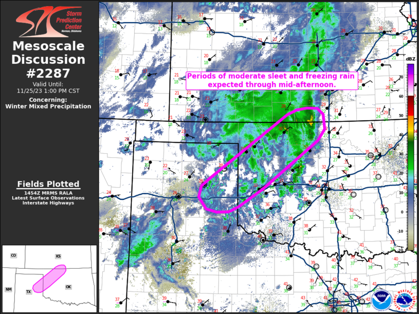
MD 2287 CONCERNING TORNADO WATCH 715… FOR LOUISIANA Mesoscale Discussion 2287 NWS Storm Prediction Center Norman OK 0457 PM CST Thu Dec 26 2024 Areas affected…Louisiana Concerning…Tornado Watch 715… Valid 262257Z – 270000Z The severe weather threat for Tornado Watch 715 continues. SUMMARY…Severe threat is expected to spread into central and southern Louisiana this evening. …
Continue reading SPC MD 2287
SPC MD 2286
MD 2286 CONCERNING TORNADO WATCH 715… FOR SOUTHEAST TEXAS Mesoscale Discussion 2286 NWS Storm Prediction Center Norman OK 0326 PM CST Thu Dec 26 2024 Areas affected…Southeast Texas Concerning…Tornado Watch 715… Valid 262126Z – 262330Z The severe weather threat for Tornado Watch 715 continues. SUMMARY…The severe threat continues across southeast TX as a broken line …
Continue reading SPC MD 2286
SPC MD 2285
MD 2285 CONCERNING TORNADO WATCH 715… FOR SOUTHEASTERN TEXAS Mesoscale Discussion 2285 NWS Storm Prediction Center Norman OK 0114 PM CST Thu Dec 26 2024 Areas affected…Southeastern Texas Concerning…Tornado Watch 715… Valid 261914Z – 262115Z The severe weather threat for Tornado Watch 715 continues. SUMMARY…The severe threat continues across much of southeast Texas as storms …
Continue reading SPC MD 2285
SPC MD 2284
MD 2284 CONCERNING SEVERE THUNDERSTORM WATCH 714… FOR NORTHEAST TEXAS INTO THE ARKLATEX VICINITY Mesoscale Discussion 2284 NWS Storm Prediction Center Norman OK 0112 PM CST Thu Dec 26 2024 Areas affected…northeast Texas into the ArkLaTex vicinity Concerning…Severe Thunderstorm Watch 714… Valid 261912Z – 262115Z The severe weather threat for Severe Thunderstorm Watch 714 continues. …
Continue reading SPC MD 2284
SPC MD 2283

MD 2283 CONCERNING SEVERE POTENTIAL…SEVERE THUNDERSTORM WATCH LIKELY FOR NORTHEAST TEXAS INTO THE ARKLATEX VICINITY Mesoscale Discussion 2283 NWS Storm Prediction Center Norman OK 1114 AM CST Thu Dec 26 2024 Areas affected…northeast Texas into the ArkLaTex vicinity Concerning…Severe potential…Severe Thunderstorm Watch likely Valid 261714Z – 261845Z Probability of Watch Issuance…95 percent SUMMARY…Severe thunderstorm potential …
Continue reading SPC MD 2283