

MD 1974 CONCERNING SEVERE POTENTIAL…WATCH POSSIBLE FOR CENTRAL HIGH PLAINS Mesoscale Discussion 1974 NWS Storm Prediction Center Norman OK 0551 PM CDT Thu Aug 22 2024 Areas affected…Central High Plains Concerning…Severe potential…Watch possible Valid 222251Z – 230045Z Probability of Watch Issuance…60 percent SUMMARY…Convection is expected to increase in areal coverage across the central High Plains …
Continue reading SPC MD 1974
Category:Weather
SPC Severe Thunderstorm Watch 644

WW 644 SEVERE TSTM CO KS NE 222325Z – 230500Z URGENT – IMMEDIATE BROADCAST REQUESTED Severe Thunderstorm Watch Number 644 NWS Storm Prediction Center Norman OK 525 PM MDT Thu Aug 22 2024 The NWS Storm Prediction Center has issued a * Severe Thunderstorm Watch for portions of Eastern Colorado Western Kansas Far Southwest Nebraska …
Continue reading SPC Severe Thunderstorm Watch 644
SPC MD 1973

MD 1973 CONCERNING SEVERE POTENTIAL…WATCH UNLIKELY FOR PORTIONS OF UTAH AND NORTHERN ARIZONA Mesoscale Discussion 1973 NWS Storm Prediction Center Norman OK 0328 PM CDT Thu Aug 22 2024 Areas affected…Portions of Utah and Northern Arizona Concerning…Severe potential…Watch unlikely Valid 222028Z – 222230Z Probability of Watch Issuance…5 percent SUMMARY…Marginal risk of large hail and damaging …
Continue reading SPC MD 1973
SPC MD 1972

MD 1972 CONCERNING SEVERE THUNDERSTORM WATCH 643… FOR EASTERN MONTANA/WESTERN NORTH DAKOTA Mesoscale Discussion 1972 NWS Storm Prediction Center Norman OK 1113 PM CDT Wed Aug 21 2024 Areas affected…eastern Montana/western North Dakota Concerning…Severe Thunderstorm Watch 643… Valid 220413Z – 220545Z The severe weather threat for Severe Thunderstorm Watch 643 continues. SUMMARY…Severe threat continues to …
Continue reading SPC MD 1972
SPC Severe Thunderstorm Watch 643 Status Reports

WW 0643 Status Updates STATUS REPORT ON WW 643 SEVERE WEATHER THREAT CONTINUES RIGHT OF A LINE FROM 30 NNW MLS TO 20 ENE OLF TO 65 NNE OLF. ..GOSS..08/22/24 ATTN…WFO…TFX…GGW… STATUS REPORT FOR WS 643 SEVERE WEATHER THREAT CONTINUES FOR THE FOLLOWING AREAS MTC021-079-083-085-091-109-220440- MT . MONTANA COUNTIES INCLUDED ARE DAWSON PRAIRIE RICHLAND ROOSEVELT …
Continue reading SPC Severe Thunderstorm Watch 643 Status Reports
SPC MD 1971

MD 1971 CONCERNING SEVERE THUNDERSTORM WATCH 642…643… FOR EASTERN MONTANA SOUTHEASTWARD TO CENTRAL SOUTH DAKOTA…AND INTO WESTERN NORTH DAKOTA Mesoscale Discussion 1971 NWS Storm Prediction Center Norman OK 0853 PM CDT Wed Aug 21 2024 Areas affected…eastern Montana southeastward to central South Dakota…and into western North Dakota Concerning…Severe Thunderstorm Watch 642…643… Valid 220153Z – 220400Z …
Continue reading SPC MD 1971
SPC Severe Thunderstorm Watch 643
WW 643 SEVERE TSTM MT 220025Z – 220700Z URGENT – IMMEDIATE BROADCAST REQUESTED Severe Thunderstorm Watch Number 643 NWS Storm Prediction Center Norman OK 625 PM MDT Wed Aug 21 2024 The NWS Storm Prediction Center has issued a * Severe Thunderstorm Watch for portions of Northeast Montana * Effective this Wednesday night and Thursday …
Continue reading SPC Severe Thunderstorm Watch 643
SPC MD 1970

MD 1970 CONCERNING SEVERE THUNDERSTORM WATCH 642… FOR EASTERN MONTANA…WESTERN NORTH DAKOTA…NORTHEASTERN WYOMING…AND PARTS OF WESTERN SOUTH DAKOTA Mesoscale Discussion 1970 NWS Storm Prediction Center Norman OK 0616 PM CDT Wed Aug 21 2024 Areas affected…eastern Montana…western North Dakota…northeastern Wyoming…and parts of western South Dakota Concerning…Severe Thunderstorm Watch 642… Valid 212316Z – 220115Z The severe …
Continue reading SPC MD 1970
SPC MD 1968
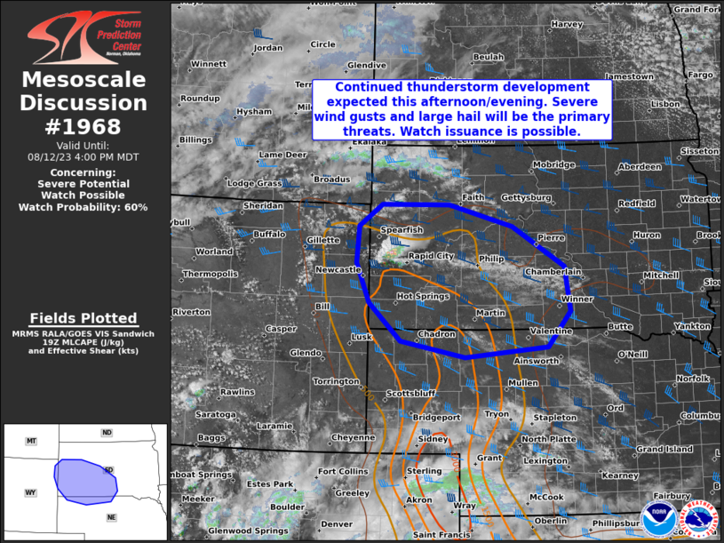
MD 1968 CONCERNING SEVERE POTENTIAL…WATCH UNLIKELY FOR PORTIONS OF SOUTHERN ARIZONA Mesoscale Discussion 1968 NWS Storm Prediction Center Norman OK 0442 PM CDT Wed Aug 21 2024 Areas affected…portions of southern Arizona Concerning…Severe potential…Watch unlikely Valid 212142Z – 212315Z Probability of Watch Issuance…20 percent SUMMARY…A few instances of severe hail/wind gusts are possible through the …
Continue reading SPC MD 1968
SPC MD 1967
MD 1967 CONCERNING SEVERE POTENTIAL…WATCH POSSIBLE FOR EASTERN WY INTO WESTERN SD/NE Mesoscale Discussion 1967 NWS Storm Prediction Center Norman OK 0255 PM CDT Wed Aug 21 2024 Areas affected…eastern WY into western SD/NE Concerning…Severe potential…Watch possible Valid 211955Z – 212100Z Probability of Watch Issuance…40 percent SUMMARY…Isolated strong to severe thunderstorms may produce gusts of …
Continue reading SPC MD 1967