
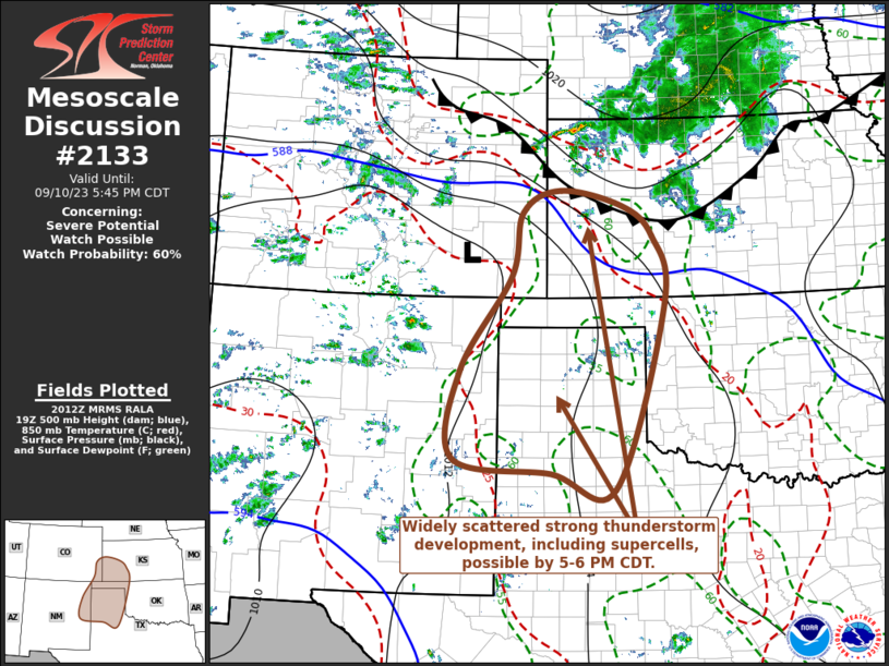
MD 2133 CONCERNING SEVERE POTENTIAL…WATCH POSSIBLE FOR PARTS OF NORTHEASTERN NEW MEXICO…SOUTHEASTERN COLORADO…AND THE TEXAS AND OKLAHOMA PANHANDLES INTO SOUTHWESTERN KANSAS Mesoscale Discussion 2133 NWS Storm Prediction Center Norman OK 0313 PM CDT Sun Sep 10 2023 Areas affected…parts of northeastern New Mexico…southeastern Colorado…and the Texas and Oklahoma Panhandles into southwestern Kansas Concerning…Severe potential…Watch possible …
Continue reading SPC MD 2133
Month:September 2023
SPC MD 2132
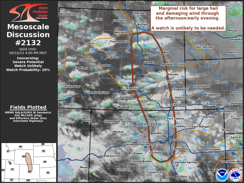
MD 2132 CONCERNING SEVERE POTENTIAL…WATCH UNLIKELY FOR PORTIONS OF EASTERN WYOMING AND NORTH-CENTRAL COLORADO Mesoscale Discussion 2132 NWS Storm Prediction Center Norman OK 0306 PM CDT Sun Sep 10 2023 Areas affected…Portions of Eastern Wyoming and North-central Colorado Concerning…Severe potential…Watch unlikely Valid 102006Z – 102200Z Probability of Watch Issuance…20 percent SUMMARY…Marginal risk for large hail …
Continue reading SPC MD 2132
SPC MD 2131
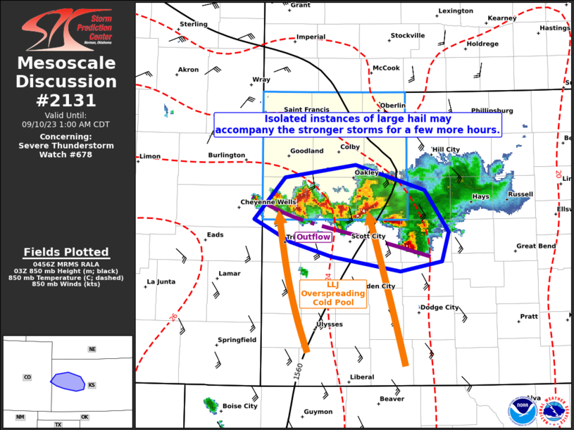
MD 2131 CONCERNING SEVERE THUNDERSTORM WATCH 678… FOR PORTIONS OF WESTERN KANSAS Mesoscale Discussion 2131 NWS Storm Prediction Center Norman OK 1158 PM CDT Sat Sep 09 2023 Areas affected…portions of western Kansas Concerning…Severe Thunderstorm Watch 678… Valid 100458Z – 100600Z The severe weather threat for Severe Thunderstorm Watch 678 continues. SUMMARY…An isolated severe threat …
Continue reading SPC MD 2131
SPC Severe Thunderstorm Watch 678 Status Reports

WW 0678 Status Updates STATUS REPORT ON WW 678 SEVERE WEATHER THREAT CONTINUES RIGHT OF A LINE FROM 35 S ITR TO 20 SE ITR TO 35 E GLD TO 20 WSW HLC. ..SQUITIERI..09/10/23 ATTN…WFO…GLD… STATUS REPORT FOR WS 678 SEVERE WEATHER THREAT CONTINUES FOR THE FOLLOWING AREAS KSC063-109-193-199-100540- KS . KANSAS COUNTIES INCLUDED ARE …
Continue reading SPC Severe Thunderstorm Watch 678 Status Reports
SPC Severe Thunderstorm Watch 679 Status Reports

WW 0679 Status Updates STATUS REPORT ON WW 679 SEVERE WEATHER THREAT CONTINUES RIGHT OF A LINE FROM 30 S DGW TO 15 SE DGW TO 30 N TOR TO 15 NE AIA. ..SQUITIERI..09/10/23 ATTN…WFO…CYS…UNR… STATUS REPORT FOR WS 679 SEVERE WEATHER THREAT CONTINUES FOR THE FOLLOWING AREAS NEC013-157-165-100540- NE . NEBRASKA COUNTIES INCLUDED ARE …
Continue reading SPC Severe Thunderstorm Watch 679 Status Reports
SPC MD 2130
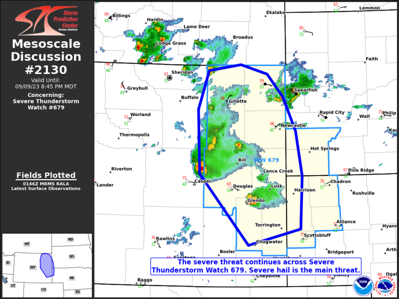
MD 2130 CONCERNING SEVERE THUNDERSTORM WATCH 679… FOR PORTIONS OF EASTERN WYOMING…EXTREME SOUTHWESTERN SOUTH DAKOTA…EXTREME NORTHWESTERN NEBRASKA Mesoscale Discussion 2130 NWS Storm Prediction Center Norman OK 0849 PM CDT Sat Sep 09 2023 Areas affected…Portions of eastern Wyoming…extreme southwestern South Dakota…extreme northwestern Nebraska Concerning…Severe Thunderstorm Watch 679… Valid 100149Z – 100245Z The severe weather threat …
Continue reading SPC MD 2130
SPC MD 2129

MD 2129 CONCERNING SEVERE THUNDERSTORM WATCH 676…678… FOR PORTIONS OF NORTHWESTERN KANSAS INTO EXTREME SOUTHWESTERN NEBRASKA Mesoscale Discussion 2129 NWS Storm Prediction Center Norman OK 0750 PM CDT Sat Sep 09 2023 Areas affected…portions of northwestern Kansas into extreme southwestern Nebraska Concerning…Severe Thunderstorm Watch 676…678… Valid 100050Z – 100145Z The severe weather threat for Severe …
Continue reading SPC MD 2129
SPC Severe Thunderstorm Watch 676 Status Reports

WW 0676 Status Updates STATUS REPORT ON WW 676 SEVERE WEATHER THREAT CONTINUES RIGHT OF A LINE FROM 25 WNW IML TO EAR. ..SQUITIERI..09/10/23 ATTN…WFO…GID…LBF… STATUS REPORT FOR WS 676 SEVERE WEATHER THREAT CONTINUES FOR THE FOLLOWING AREAS NEC029-063-065-073-085-100140- NE . NEBRASKA COUNTIES INCLUDED ARE CHASE FRONTIER FURNAS GOSPER HAYES THE WATCH STATUS MESSAGE IS …
Continue reading SPC Severe Thunderstorm Watch 676 Status Reports
SPC Severe Thunderstorm Watch 676
WW 676 SEVERE TSTM NE 091945Z – 100200Z URGENT – IMMEDIATE BROADCAST REQUESTED Severe Thunderstorm Watch Number 676 NWS Storm Prediction Center Norman OK 245 PM CDT Sat Sep 9 2023 The NWS Storm Prediction Center has issued a * Severe Thunderstorm Watch for portions of Southwest and South-Central Nebraska * Effective this Saturday afternoon …
Continue reading SPC Severe Thunderstorm Watch 676
SPC MD 2128
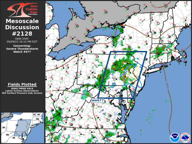
MD 2128 CONCERNING SEVERE THUNDERSTORM WATCH 677… FOR MIDDLE ATLANTIC Mesoscale Discussion 2128 NWS Storm Prediction Center Norman OK 0708 PM CDT Sat Sep 09 2023 Areas affected…Middle Atlantic Concerning…Severe Thunderstorm Watch 677… Valid 100008Z – 100215Z The severe weather threat for Severe Thunderstorm Watch 677 continues. SUMMARY…Severe threat is gradually waning across the Middle …
Continue reading SPC MD 2128