
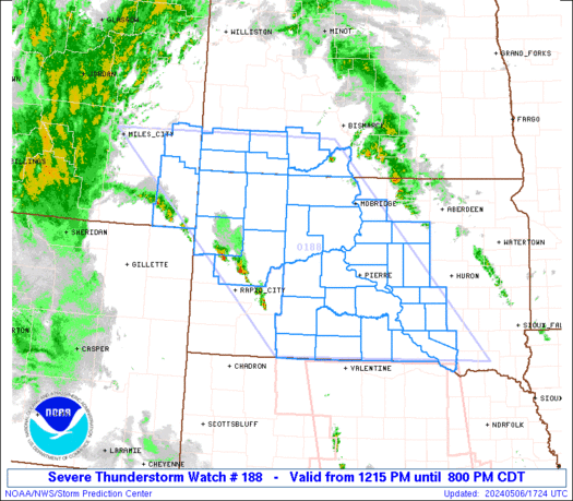
WW 188 SEVERE TSTM MT ND SD 061715Z – 070100Z URGENT – IMMEDIATE BROADCAST REQUESTED Severe Thunderstorm Watch Number 188 NWS Storm Prediction Center Norman OK 1215 PM CDT Mon May 6 2024 The NWS Storm Prediction Center has issued a * Severe Thunderstorm Watch for portions of Southeast Montana Southwest North Dakota Central and …
Continue reading SPC Severe Thunderstorm Watch 188
Month:May 2024
SPC PDS Tornado Watch 189

WW 189 TORNADO KS OK TX 061900Z – 070400Z URGENT – IMMEDIATE BROADCAST REQUESTED Tornado Watch Number 189 NWS Storm Prediction Center Norman OK 200 PM CDT Mon May 6 2024 The NWS Storm Prediction Center has issued a * Tornado Watch for portions of Southern Kansas Western and Central Oklahoma Western North Texas * …
Continue reading SPC PDS Tornado Watch 189
SPC Tornado Watch 190

WW 190 TORNADO IA KS MO NE 062045Z – 070400Z URGENT – IMMEDIATE BROADCAST REQUESTED Tornado Watch Number 190 NWS Storm Prediction Center Norman OK 345 PM CDT Mon May 6 2024 The NWS Storm Prediction Center has issued a * Tornado Watch for portions of Western Iowa Northeast and Eastern Kansas Far Northwest Missouri …
Continue reading SPC Tornado Watch 190
SPC MD 657
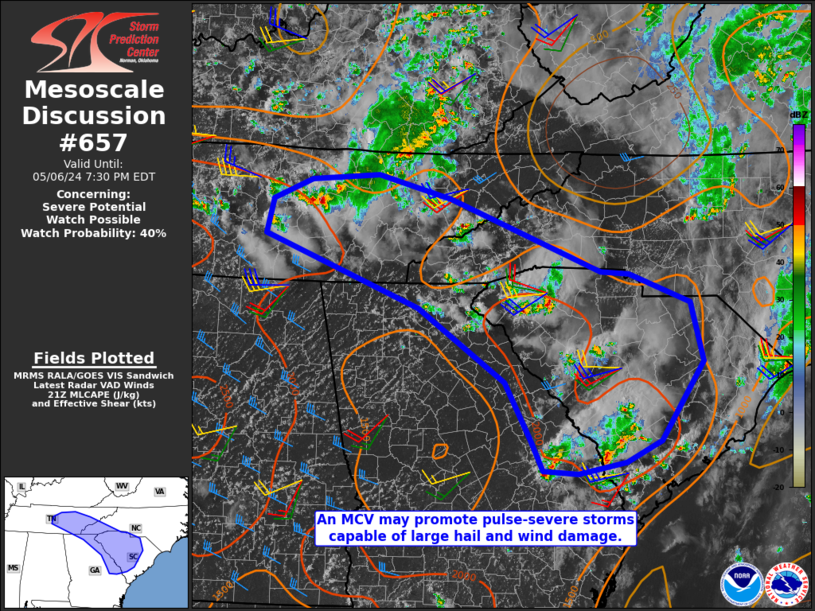
MD 0657 CONCERNING SEVERE POTENTIAL…WATCH POSSIBLE FOR PORTIONS OF SOUTH CAROLINA AND TENNESSEE VALLEY Mesoscale Discussion 0657 NWS Storm Prediction Center Norman OK 0453 PM CDT Mon May 06 2024 Areas affected…Portions of South Carolina and Tennessee Valley Concerning…Severe potential…Watch possible Valid 062153Z – 062330Z Probability of Watch Issuance…40 percent SUMMARY…Large hail and damaging winds …
Continue reading SPC MD 657
SPC MD 655
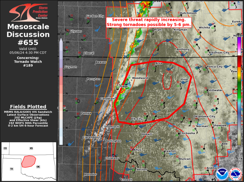
MD 0655 CONCERNING TORNADO WATCH 189… FOR NORTHWEST OK Mesoscale Discussion 0655 NWS Storm Prediction Center Norman OK 0335 PM CDT Mon May 06 2024 Areas affected…Northwest OK Concerning…Tornado Watch 189… Valid 062035Z – 062130Z The severe weather threat for Tornado Watch 189 continues. SUMMARY…Initial supercell development across northwest Oklahoma will pose a primary near-term …
Continue reading SPC MD 655
SPC MD 656
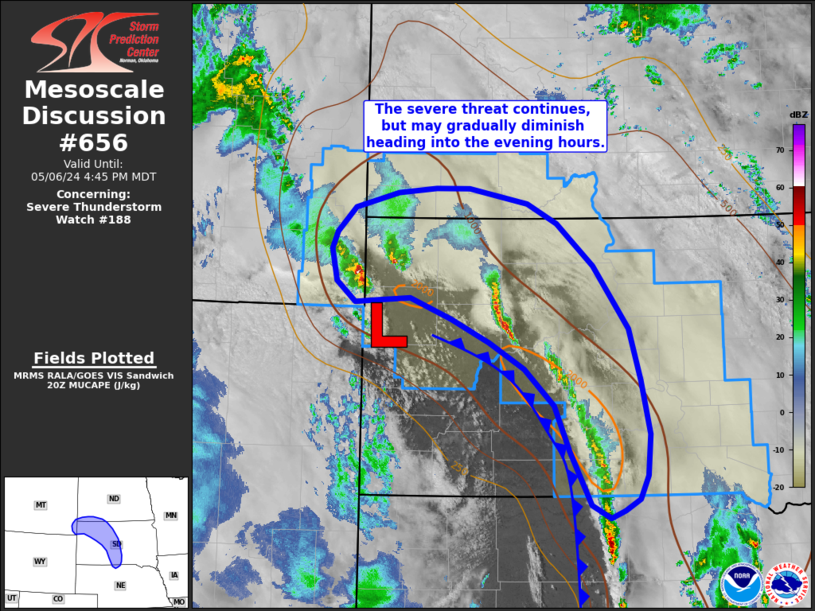
MD 0656 CONCERNING SEVERE THUNDERSTORM WATCH 188… FOR SOUTH-CENTRAL TO NORTHWEST SOUTH DAKOTA Mesoscale Discussion 0656 NWS Storm Prediction Center Norman OK 0351 PM CDT Mon May 06 2024 Areas affected…South-central to northwest South Dakota Concerning…Severe Thunderstorm Watch 188… Valid 062051Z – 062245Z The severe weather threat for Severe Thunderstorm Watch 188 continues. SUMMARY…The potential …
Continue reading SPC MD 656
iPhone 16 Models Rumored to Come in These Colors
Apple will unveil its new iPhone 16 lineup in a range of new colors later this year in the fall. Here are all the rumored colors so far for the four models: iPhone 16, iPhone 16 Plus, iPhone 16 Pro, and iPhone 16 Pro Max. iPhone 16 and iPhone 16 Plus In the last few …
Continue reading iPhone 16 Models Rumored to Come in These Colors
SPC MD 653

MD 0653 CONCERNING TORNADO WATCH 187…189… FOR SOUTH-CENTRAL KS Mesoscale Discussion 0653 NWS Storm Prediction Center Norman OK 0245 PM CDT Mon May 06 2024 Areas affected…South-central KS Concerning…Tornado Watch 187…189… Valid 061945Z – 062045Z The severe weather threat for Tornado Watch 187, 189 continues. SUMMARY…Initial supercells just east of Dodge City will intensify as …
Continue reading SPC MD 653
SPC MD 654

MD 0654 CONCERNING SEVERE POTENTIAL…WATCH LIKELY FOR EASTERN NEBRASKA AND NORTHEAST KANSAS Mesoscale Discussion 0654 NWS Storm Prediction Center Norman OK 0307 PM CDT Mon May 06 2024 Areas affected…Eastern Nebraska and northeast Kansas Concerning…Severe potential…Watch likely Valid 062007Z – 062200Z Probability of Watch Issuance…80 percent SUMMARY…Ongoing thunderstorms across WW 187 are expected to exit …
Continue reading SPC MD 654
SPC MD 651

MD 0651 CONCERNING TORNADO WATCH 187… FOR CENTRAL KS AND SOUTH-CENTRAL NE Mesoscale Discussion 0651 NWS Storm Prediction Center Norman OK 0158 PM CDT Mon May 06 2024 Areas affected…Central KS and south-central NE Concerning…Tornado Watch 187… Valid 061858Z – 062030Z The severe weather threat for Tornado Watch 187 continues. SUMMARY…Overall severe threat, primarily in …
Continue reading SPC MD 651