

MD 2171 CONCERNING SEVERE THUNDERSTORM WATCH 629… FOR NORTH TEXAS Mesoscale Discussion 2171 NWS Storm Prediction Center Norman OK 0600 PM CDT Fri Oct 24 2025 Areas affected…North Texas Concerning…Severe Thunderstorm Watch 629… Valid 242300Z – 250030Z The severe weather threat for Severe Thunderstorm Watch 629 continues. SUMMARY…A locally greater tornado threat is evident near …
Continue reading SPC MD 2171
Category:Weather
SPC Severe Thunderstorm Watch 628 Status Reports

WW 0628 Status Updates STATUS REPORT ON WW 628 SEVERE WEATHER THREAT CONTINUES RIGHT OF A LINE FROM 60 SSE MRF TO 10 E SJT TO 15 N BWD TO 40 WSW MWL TO 25 ESE CSM TO 25 W LTS TO 50 SE LBB TO 40 S LBB TO 30 SSW LBB. PARTS OF …
Continue reading SPC Severe Thunderstorm Watch 628 Status Reports
SPC Severe Thunderstorm Watch 628
WW 628 SEVERE TSTM OK TX 241705Z – 250000Z URGENT – IMMEDIATE BROADCAST REQUESTED Severe Thunderstorm Watch Number 628 NWS Storm Prediction Center Norman OK 1205 PM CDT Fri Oct 24 2025 The NWS Storm Prediction Center has issued a * Severe Thunderstorm Watch for portions of Southwest Oklahoma Western and Central Texas * Effective …
Continue reading SPC Severe Thunderstorm Watch 628
SPC Severe Thunderstorm Watch 629

WW 629 SEVERE TSTM TX 242210Z – 250500Z URGENT – IMMEDIATE BROADCAST REQUESTED Severe Thunderstorm Watch Number 629 NWS Storm Prediction Center Norman OK 510 PM CDT Fri Oct 24 2025 The NWS Storm Prediction Center has issued a * Severe Thunderstorm Watch for portions of North Central and West Central Texas * Effective this …
Continue reading SPC Severe Thunderstorm Watch 629
SPC MD 2170
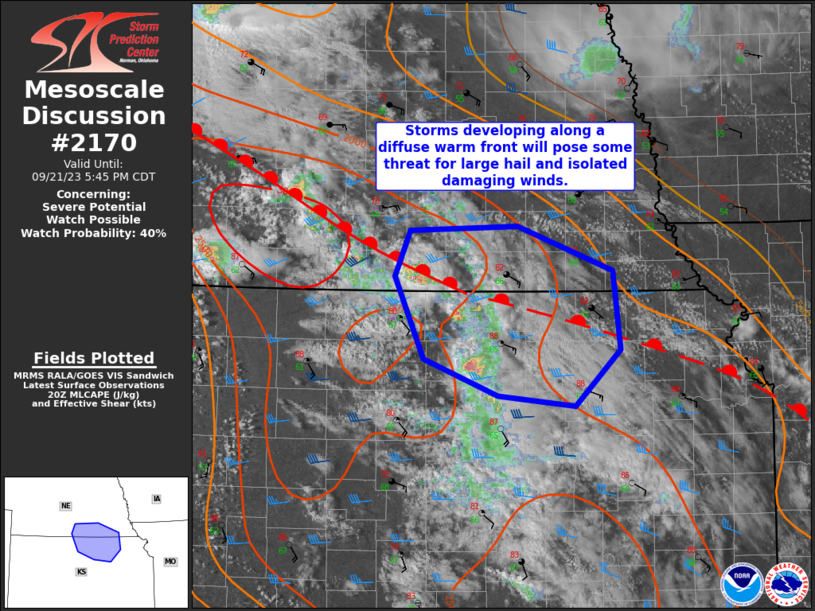
MD 2170 CONCERNING SEVERE POTENTIAL…WATCH POSSIBLE FOR FROM PARTS OF NORTH-CENTRAL TEXAS INTO THE RED RIVER VALLEY Mesoscale Discussion 2170 NWS Storm Prediction Center Norman OK 0333 PM CDT Fri Oct 24 2025 Areas affected…from parts of north-central Texas into the Red River Valley Concerning…Severe potential…Watch possible Valid 242033Z – 242230Z Probability of Watch Issuance…60 …
Continue reading SPC MD 2170
SPC MD 2169
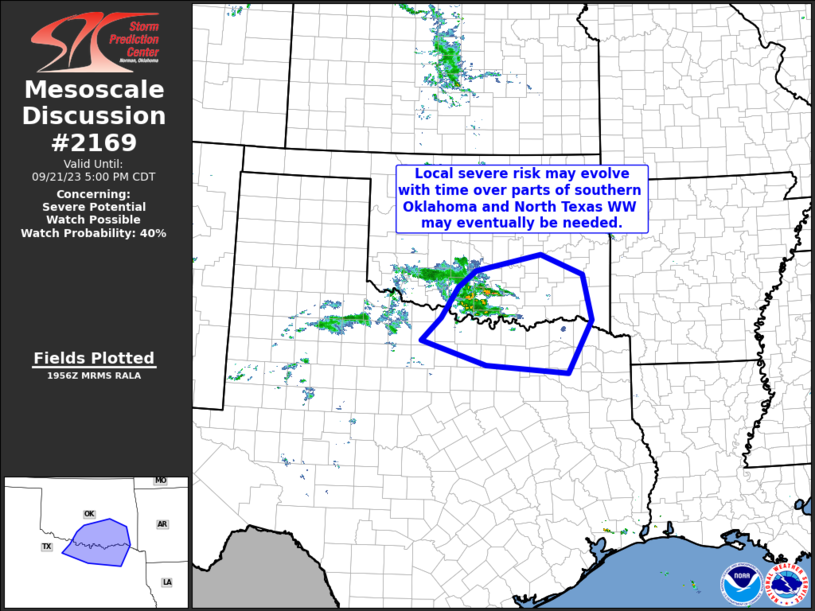
MD 2169 CONCERNING SEVERE THUNDERSTORM WATCH 628… FOR SOUTHWEST TEXAS Mesoscale Discussion 2169 NWS Storm Prediction Center Norman OK 0255 PM CDT Fri Oct 24 2025 Areas affected…southwest Texas Concerning…Severe Thunderstorm Watch 628… Valid 241955Z – 242230Z The severe weather threat for Severe Thunderstorm Watch 628 continues. SUMMARY…A possible supercell with large hail potential appears …
Continue reading SPC MD 2169
SPC MD 2168
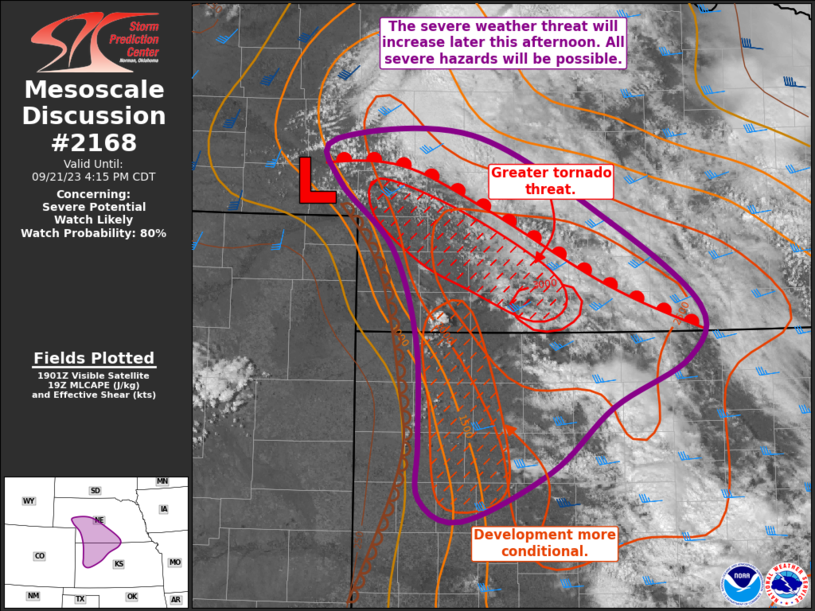
MD 2168 CONCERNING SEVERE POTENTIAL…WATCH POSSIBLE FOR TEXAS PANHANDLE AND WESTERN OKLAHOMA Mesoscale Discussion 2168 NWS Storm Prediction Center Norman OK 0104 PM CDT Fri Oct 24 2025 Areas affected…Texas Panhandle and western Oklahoma Concerning…Severe potential…Watch possible Valid 241804Z – 242030Z Probability of Watch Issuance…40 percent SUMMARY…Scattered thunderstorms are developing across the region, a few …
Continue reading SPC MD 2168
SPC MD 2167

MD 2167 CONCERNING SEVERE POTENTIAL…WATCH LIKELY FOR MUCH OF WESTERN TEXAS Mesoscale Discussion 2167 NWS Storm Prediction Center Norman OK 1105 AM CDT Fri Oct 24 2025 Areas affected…much of western Texas Concerning…Severe potential…Watch likely Valid 241605Z – 241830Z Probability of Watch Issuance…95 percent SUMMARY…Storms capable of large, damaging hail and eventually damaging winds are …
Continue reading SPC MD 2167
SPC MD 2166
MD 2166 CONCERNING SEVERE POTENTIAL…WATCH UNLIKELY FOR PERMIAN BASIN INTO ROLLING PLAINS Mesoscale Discussion 2166 NWS Storm Prediction Center Norman OK 0835 PM CDT Thu Oct 23 2025 Areas affected…Permian Basin into Rolling Plains Concerning…Severe potential…Watch unlikely Valid 240135Z – 240330Z Probability of Watch Issuance…20 percent SUMMARY…Isolated large hail and marginally severe winds could occur …
Continue reading SPC MD 2166
SPC MD 2165

MD 2165 CONCERNING SEVERE POTENTIAL…WATCH POSSIBLE FOR PERMIAN BASIN INTO TEXAS SOUTH PLAINS Mesoscale Discussion 2165 NWS Storm Prediction Center Norman OK 0639 PM CDT Thu Oct 23 2025 Areas affected…Permian Basin into Texas South Plains Concerning…Severe potential…Watch possible Valid 232339Z – 240045Z Probability of Watch Issuance…40 percent SUMMARY…Large to conditionally very-large hail and isolated …
Continue reading SPC MD 2165