

WW 622 SEVERE TSTM CA CW 140615Z – 141300Z URGENT – IMMEDIATE BROADCAST REQUESTED Severe Thunderstorm Watch Number 622 NWS Storm Prediction Center Norman OK 1115 PM PDT Mon Oct 13 2025 The NWS Storm Prediction Center has issued a * Severe Thunderstorm Watch for portions of Southern California Coastal Waters * Effective this Monday …
Continue reading SPC Severe Thunderstorm Watch 622
Category:Weather
SPC MD 2145
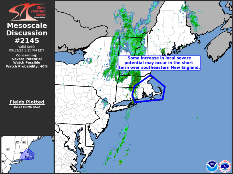
MD 2145 CONCERNING SEVERE POTENTIAL…WATCH UNLIKELY FOR PORTIONS OF SOUTH-CENTRAL COASTAL CALIFORNIA. Mesoscale Discussion 2145 NWS Storm Prediction Center Norman OK 1144 PM CDT Mon Oct 13 2025 Areas affected…portions of south-central coastal California. Concerning…Severe potential…Watch unlikely Valid 140444Z – 140645Z Probability of Watch Issuance…5 percent SUMMARY…A band of low-topped convection, expected to move onshore …
Continue reading SPC MD 2145
SPC MD 2144

MD 2144 CONCERNING SEVERE POTENTIAL…WATCH UNLIKELY FOR CENTRAL ARIZONA Mesoscale Discussion 2144 NWS Storm Prediction Center Norman OK 0241 PM CDT Mon Oct 13 2025 Areas affected…Central Arizona Concerning…Severe potential…Watch unlikely Valid 131941Z – 132145Z Probability of Watch Issuance…5 percent SUMMARY…Thunderstorms are expected to increase in coverage through the evening hours. Sporadic hail and severe …
Continue reading SPC MD 2144
SPC MD 2143

MD 2143 CONCERNING SEVERE POTENTIAL…WATCH UNLIKELY FOR SOUTHEAST AZ Mesoscale Discussion 2143 NWS Storm Prediction Center Norman OK 0521 PM CDT Sat Oct 11 2025 Areas affected…Southeast AZ Concerning…Severe potential…Watch unlikely Valid 112221Z – 120015Z Probability of Watch Issuance…5 percent SUMMARY…Isolated strong to severe storms are possible through the remainder of the afternoon. DISCUSSION…A storm …
Continue reading SPC MD 2143
SPC MD 2142

MD 2142 CONCERNING SEVERE POTENTIAL…WATCH UNLIKELY FOR MUCH OF NORTHERN AND WESTERN UTAH INTO FAR EAST-CENTRAL NEVADA Mesoscale Discussion 2142 NWS Storm Prediction Center Norman OK 0256 PM CDT Sat Oct 11 2025 Areas affected…much of northern and western Utah into far east-central Nevada Concerning…Severe potential…Watch unlikely Valid 111956Z – 112230Z Probability of Watch Issuance…20 …
Continue reading SPC MD 2142
SPC MD 2141

MD 2141 CONCERNING SEVERE POTENTIAL…WATCH UNLIKELY FOR PARTS OF SOUTHERN NEVADA AND ADJACENT PORTIONS OF SOUTHEASTERN CALIFORNIA AND SOUTHWESTERN UTAH Mesoscale Discussion 2141 NWS Storm Prediction Center Norman OK 0401 PM CDT Fri Oct 10 2025 Areas affected…parts of southern Nevada and adjacent portions of southeastern California and southwestern Utah Concerning…Severe potential…Watch unlikely Valid 102101Z …
Continue reading SPC MD 2141
SPC MD 2140
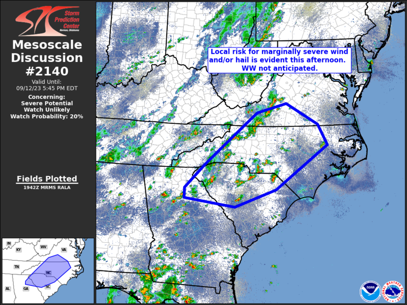
MD 2140 CONCERNING SEVERE POTENTIAL…WATCH UNLIKELY FOR PORTIONS OF CENTRAL NEW MEXICO Mesoscale Discussion 2140 NWS Storm Prediction Center Norman OK 0607 PM CDT Tue Oct 07 2025 Areas affected…portions of central New Mexico Concerning…Severe potential…Watch unlikely Valid 072307Z – 080100Z Probability of Watch Issuance…20 percent SUMMARY…Isolated supercells may produce severe hail over the next …
Continue reading SPC MD 2140
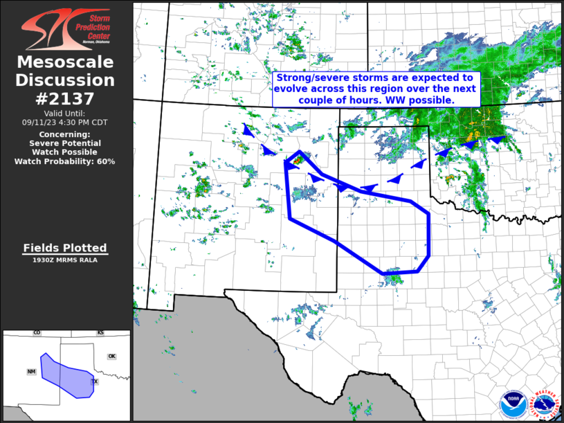
SPC MD 2139

MD 2139 CONCERNING SEVERE POTENTIAL…WATCH UNLIKELY FOR PARTS OF CENTRAL NEW MEXICO Mesoscale Discussion 2139 NWS Storm Prediction Center Norman OK 0329 PM CDT Tue Oct 07 2025 Areas affected…parts of central New Mexico Concerning…Severe potential…Watch unlikely Valid 072029Z – 072300Z Probability of Watch Issuance…5 percent SUMMARY…The evolution of one or two supercells posing a …
Continue reading SPC MD 2139
SPC MD 2138
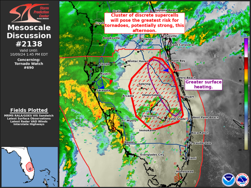
MD 2138 CONCERNING SEVERE POTENTIAL…WATCH UNLIKELY FOR SOUTHEAST LOUISIANA INTO SOUTHERN MISSISSIPPI. Mesoscale Discussion 2138 NWS Storm Prediction Center Norman OK 0542 AM CDT Mon Oct 06 2025 Areas affected…Southeast Louisiana into southern Mississippi. Concerning…Severe potential…Watch unlikely Valid 061042Z – 061215Z Probability of Watch Issuance…5 percent SUMMARY…A few rotating showers/thunderstorms may persist for a few …
Continue reading SPC MD 2138
SPC MD 2137
MD 2137 CONCERNING SEVERE POTENTIAL…WATCH UNLIKELY FOR SOUTHWEST TO NORTHEAST KANSAS AND FAR SOUTHEAST NEBRASKA Mesoscale Discussion 2137 NWS Storm Prediction Center Norman OK 0350 PM CDT Sun Oct 05 2025 Areas affected…southwest to northeast Kansas and far southeast Nebraska Concerning…Severe potential…Watch unlikely Valid 052050Z – 052315Z Probability of Watch Issuance…20 percent SUMMARY…Strong to isolated …
Continue reading SPC MD 2137