

MD 0066 CONCERNING WINTER MIXED PRECIPITATION FOR MUCH OF PENNSYLVANIA…NORTHERN MARYLAND…NORTHERN DELAWARE…WESTERN NEW JERSEY…AND SOUTHWESTERN NEW YORK. Mesoscale Discussion 0066 NWS Storm Prediction Center Norman OK 0300 AM CST Thu Feb 06 2025 Areas affected…much of Pennsylvania…northern Maryland…northern Delaware…western New Jersey…and southwestern New York. Concerning…Winter mixed precipitation Valid 060900Z – 061400Z SUMMARY…A mixture of sleet, …
Continue reading SPC MD 66
Category:Weather
SPC MD 65

MD 0065 CONCERNING SEVERE POTENTIAL…WATCH POSSIBLE FOR PORTIONS OF NORTHERN TENNESSEE AND SOUTHERN KENTUCKY Mesoscale Discussion 0065 NWS Storm Prediction Center Norman OK 1208 AM CST Thu Feb 06 2025 Areas affected…portions of northern Tennessee and southern Kentucky Concerning…Severe potential…Watch possible Valid 060608Z – 060815Z Probability of Watch Issuance…40 percent SUMMARY…Ongoing weak destabilization within the …
Continue reading SPC MD 65
SPC MD 64

MD 0064 CONCERNING FREEZING RAIN FOR PORTIONS OF EASTERN INDIANA AND MUCH OF NORTH-CENTRAL OHIO Mesoscale Discussion 0064 NWS Storm Prediction Center Norman OK 0843 PM CST Wed Feb 05 2025 Areas affected…portions of eastern Indiana and much of north-central Ohio Concerning…Freezing rain Valid 060243Z – 060845Z SUMMARY…Freezing drizzle and light freezing rain showers are …
Continue reading SPC MD 64
SPC MD 63

MD 0063 CONCERNING HEAVY SNOW FOR SOUTHWEST OR INTO EXTREME NORTHERN CA Mesoscale Discussion 0063 NWS Storm Prediction Center Norman OK 0401 PM CST Mon Feb 03 2025 Areas affected…Southwest OR into extreme northern CA Concerning…Heavy snow Valid 032201Z – 040100Z SUMMARY…Locally heavy snow rates will continue through the afternoon. DISCUSSION…Moderate to locally heavy precipitation …
Continue reading SPC MD 63
SPC MD 62

MD 0062 CONCERNING HEAVY SNOW FOR PORTIONS OF CENTRAL AND NORTHERN MINNESOTA Mesoscale Discussion 0062 NWS Storm Prediction Center Norman OK 0208 PM CST Sat Feb 01 2025 Areas affected…Portions of central and northern Minnesota Concerning…Heavy snow Valid 012008Z – 020015Z SUMMARY…Moderate to locally heavy snowfall is expected to develop across portions of central MN …
Continue reading SPC MD 62
SPC MD 61
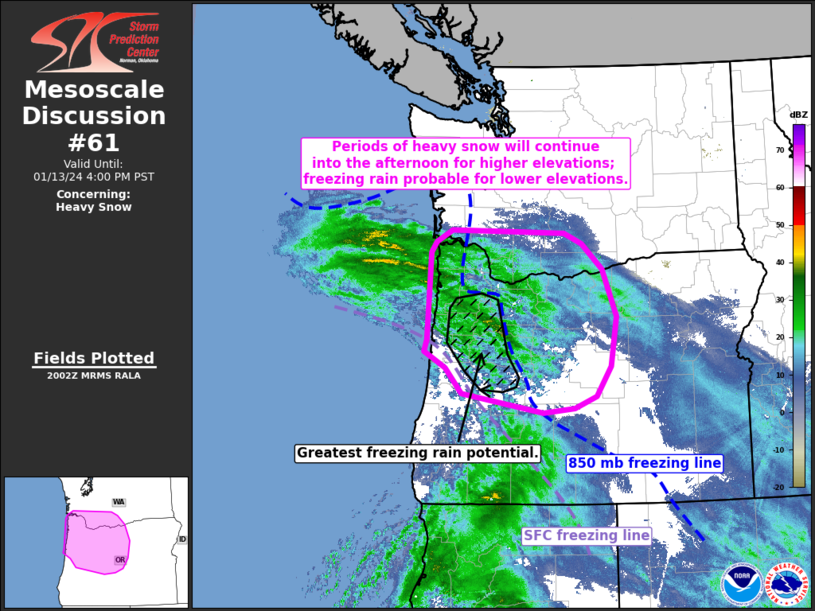
MD 0061 CONCERNING SEVERE POTENTIAL…WATCH UNLIKELY FOR FL PANHANDLE…SOUTHEAST AL…SOUTHWEST GA Mesoscale Discussion 0061 NWS Storm Prediction Center Norman OK 1245 PM CST Fri Jan 31 2025 Areas affected…FL Panhandle…southeast AL…southwest GA Concerning…Severe potential…Watch unlikely Valid 311845Z – 312115Z Probability of Watch Issuance…5 percent SUMMARY…Isolated strong/damaging gusts cannot be ruled out this afternoon. DISCUSSION…A low-topped …
Continue reading SPC MD 61
SPC MD 60

MD 0060 CONCERNING SEVERE POTENTIAL…WATCH UNLIKELY FOR CENTRAL/SOUTHERN PORTIONS OF MS/LA Mesoscale Discussion 0060 NWS Storm Prediction Center Norman OK 1006 PM CST Thu Jan 30 2025 Areas affected…central/southern portions of MS/LA Concerning…Severe potential…Watch unlikely Valid 310406Z – 310600Z Probability of Watch Issuance…20 percent SUMMARY…Locally strong gusts and a brief tornado should be the main …
Continue reading SPC MD 60
SPC MD 59

MD 0059 CONCERNING SEVERE POTENTIAL…WATCH UNLIKELY FOR PARTS OF NORTHERN LOUISIANA AND SOUTHERN ARKANSAS Mesoscale Discussion 0059 NWS Storm Prediction Center Norman OK 0317 PM CST Thu Jan 30 2025 Areas affected…parts of northern Louisiana and southern Arkansas Concerning…Severe potential…Watch unlikely Valid 302117Z – 302345Z Probability of Watch Issuance…20 percent SUMMARY…A gradual increase in thunderstorms …
Continue reading SPC MD 59
SPC MD 58

MD 0058 CONCERNING SEVERE POTENTIAL…WATCH UNLIKELY FOR SOUTH CENTRAL INTO NORTH CENTRAL TEXAS Mesoscale Discussion 0058 NWS Storm Prediction Center Norman OK 0242 AM CST Thu Jan 30 2025 Areas affected…south central into north central Texas Concerning…Severe potential…Watch unlikely Valid 300842Z – 301145Z Probability of Watch Issuance…20 percent SUMMARY…In advance of an evolving line of …
Continue reading SPC MD 58
SPC MD 57

MD 0057 CONCERNING SNOW SQUALL FOR PORTIONS OF EXTREME NORTHEAST PENNSYLVANIA…FAR EASTERN NEW YORK…MASSACHUSETTS…VERMONT…NEW HAMPSHIRE Mesoscale Discussion 0057 NWS Storm Prediction Center Norman OK 1039 AM CST Wed Jan 29 2025 Areas affected…portions of extreme northeast Pennsylvania…far eastern New York…Massachusetts…Vermont…New Hampshire Concerning…Snow Squall Valid 291639Z – 291845Z SUMMARY…Occasional snow-squall conditions are possible in stronger portions …
Continue reading SPC MD 57