

MD 2254 CONCERNING FREEZING RAIN FOR SOUTHEAST NORTH DAKOTA INTO NORTHEAST SOUTH DAKOTA AND FAR WESTERN MINNESOTA Mesoscale Discussion 2254 NWS Storm Prediction Center Norman OK 0902 AM CST Tue Dec 09 2025 Areas affected…Southeast North Dakota into northeast South Dakota and far western Minnesota Concerning…Freezing rain Valid 091502Z – 091800Z SUMMARY…Light freezing rain accumulations …
Continue reading SPC MD 2254
Category:Weather
SPC MD 2253
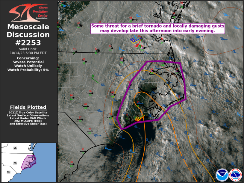
MD 2253 CONCERNING SEVERE POTENTIAL…WATCH UNLIKELY FOR WEST-CENTRAL FLORIDA Mesoscale Discussion 2253 NWS Storm Prediction Center Norman OK 0646 PM CST Sun Dec 07 2025 Areas affected…West-central Florida Concerning…Severe potential…Watch unlikely Valid 080046Z – 080245Z Probability of Watch Issuance…20 percent SUMMARY…Sporadic damaging winds and an isolated tornado threat will continue this evening. DISCUSSION…A line of …
Continue reading SPC MD 2253
SPC MD 2252
MD 2252 CONCERNING SEVERE POTENTIAL…WATCH UNLIKELY FOR PARTS OF WEST-CENTRAL FL Mesoscale Discussion 2252 NWS Storm Prediction Center Norman OK 0356 PM CST Sun Dec 07 2025 Areas affected…Parts of west-central FL Concerning…Severe potential…Watch unlikely Valid 072156Z – 080030Z Probability of Watch Issuance…20 percent SUMMARY…Locally damaging wind and a brief tornado are possible this evening. …
Continue reading SPC MD 2252
SPC MD 2251

MD 2251 CONCERNING HEAVY SNOW FOR CENTRAL IOWA Mesoscale Discussion 2251 NWS Storm Prediction Center Norman OK 0654 PM CST Sat Dec 06 2025 Areas affected…central Iowa Concerning…Heavy snow Valid 070054Z – 070400Z SUMMARY…Moderate to heavy snow to continue across portions of central Iowa over the next couple of hours. Occasional rates 1″/hr with heavier …
Continue reading SPC MD 2251
SPC MD 2250

MD 2250 CONCERNING HEAVY SNOW FOR FAR SOUTHEAST SOUTH DAKOTA AND NORTHWESTERN IOWA Mesoscale Discussion 2250 NWS Storm Prediction Center Norman OK 1225 PM CST Sat Dec 06 2025 Areas affected…Far southeast South Dakota and northwestern Iowa Concerning…Heavy snow Valid 061825Z – 070030Z SUMMARY…Periods of heavy snowfall are developing across portions of far southeastern SD, …
Continue reading SPC MD 2250
SPC MD 2249
MD 2249 CONCERNING HEAVY SNOW FOR COASTAL NORTHERN NEW ENGLAND Mesoscale Discussion 2249 NWS Storm Prediction Center Norman OK 0712 PM CST Tue Dec 02 2025 Areas affected…coastal northern New England Concerning…Heavy snow Valid 030112Z – 030715Z SUMMARY…Moderate to heavy snow rates on the order of 1/2 to 1+ inches per hour are possible across …
Continue reading SPC MD 2249
SPC MD 2248
MD 2248 CONCERNING HEAVY SNOW FOR SOUTHERN NEW YORK INTO NEW ENGLAND Mesoscale Discussion 2248 NWS Storm Prediction Center Norman OK 1234 PM CST Tue Dec 02 2025 Areas affected…Southern New York into New England Concerning…Heavy snow Valid 021834Z – 022230Z SUMMARY…Heavy snowfall rates between 1-2 inches per hour remain likely across southern New York …
Continue reading SPC MD 2248
SPC MD 2247

MD 2247 CONCERNING WINTER MIXED PRECIPITATION FOR EASTERN PENNSYLVANIA INTO SOUTHERN NEW YORK…WESTERN MASSACHUSETTS…AND WESTERN CONNECTICUT. Mesoscale Discussion 2247 NWS Storm Prediction Center Norman OK 0851 AM CST Tue Dec 02 2025 Areas affected…eastern Pennsylvania into southern New York…western Massachusetts…and western Connecticut. Concerning…Winter mixed precipitation Valid 021451Z – 021745Z SUMMARY…A combination of freezing rain, sleet, …
Continue reading SPC MD 2247
SPC MD 2246
MD 2246 CONCERNING HEAVY SNOW FOR OH…NORTHERN WV PANHANDLE…AND WESTERN PA Mesoscale Discussion 2246 NWS Storm Prediction Center Norman OK 0354 AM CST Tue Dec 02 2025 Areas affected…OH…northern WV Panhandle…and western PA Concerning…Heavy snow Valid 020954Z – 021400Z SUMMARY…Snowfall rates could exceed 1″/hr from OH into the northern WV Panhandle and western PA over …
Continue reading SPC MD 2246
SPC MD 2245
MD 2245 CONCERNING WINTER MIXED PRECIPITATION FOR WV…NORTHWESTERN VA…WESTERN MD…AND FAR SOUTHWEST PA Mesoscale Discussion 2245 NWS Storm Prediction Center Norman OK 0159 AM CST Tue Dec 02 2025 Areas affected…WV…northwestern VA…western MD…and far southwest PA Concerning…Winter mixed precipitation Valid 020759Z – 021200Z SUMMARY…Several hours of freezing rain are possible this morning from WV into …
Continue reading SPC MD 2245