

MD 0829 CONCERNING SEVERE POTENTIAL…WATCH POSSIBLE FOR PARTS OF SOUTHEAST FL Mesoscale Discussion 0829 NWS Storm Prediction Center Norman OK 1117 AM CDT Sun May 19 2024 Areas affected…Parts of southeast FL Concerning…Severe potential…Watch possible Valid 191617Z – 191815Z Probability of Watch Issuance…40 percent SUMMARY…A few severe storms are possible this afternoon, with a threat …
Continue reading SPC MD 829
Month:May 2024
AirTag With New Chip and Improved Location Tracking Due Next Year
Apple’s next-generation AirTag item tracker is on track to launch in mid-2025, Bloomberg‘s Mark Gurman reports. In his latest “Power On” newsletter, Gurman discussed Apple’s work on the next-generation version of the AirTag, codenamed “B589.” Apple is currently completing manufacturing tests with partners in Asia and the new item tracker is still timetabled to launch …
Continue reading AirTag With New Chip and Improved Location Tracking Due Next Year
Gurman: No New Mac Studio and Mac Pro Until Mid-2025
Apple will not refresh the Mac Studio and Mac Pro with next-generation high-end chips until the middle of 2025, according to Bloomberg‘s Mark Gurman. In the latest edition of his “Power On” newsletter, Gurman said that Apple’s current schedule does not include the launch of new Mac Studio and Mac Pro models until the middle …
Continue reading Gurman: No New Mac Studio and Mac Pro Until Mid-2025
SPC Severe Thunderstorm Watch 257 Status Reports
WW 0257 Status Updates STATUS REPORT ON WW 257 SEVERE WEATHER THREAT CONTINUES RIGHT OF A LINE FROM 25 NNE VOK TO 30 NE IWD TO 25 SW CMX. ..KERR..05/19/24 ATTN…WFO…MQT…DLH…ARX…GRB… STATUS REPORT FOR WS 257 SEVERE WEATHER THREAT CONTINUES FOR THE FOLLOWING AREAS MIC013-053-061-071-131-190140- MI . MICHIGAN COUNTIES INCLUDED ARE BARAGA GOGEBIC HOUGHTON IRON …
Continue reading SPC Severe Thunderstorm Watch 257 Status Reports
SPC MD 828

MD 0828 CONCERNING SEVERE THUNDERSTORM WATCH 257… FOR PARTS OF CENTRAL/NORTHEASTERN WISCONSIN INTO ADJACENT PORTIONS OF UPPER MICHIGAN Mesoscale Discussion 0828 NWS Storm Prediction Center Norman OK 0546 PM CDT Sat May 18 2024 Areas affected…parts of central/northeastern Wisconsin into adjacent portions of Upper Michigan Concerning…Severe Thunderstorm Watch 257… Valid 182246Z – 190045Z The severe …
Continue reading SPC MD 828
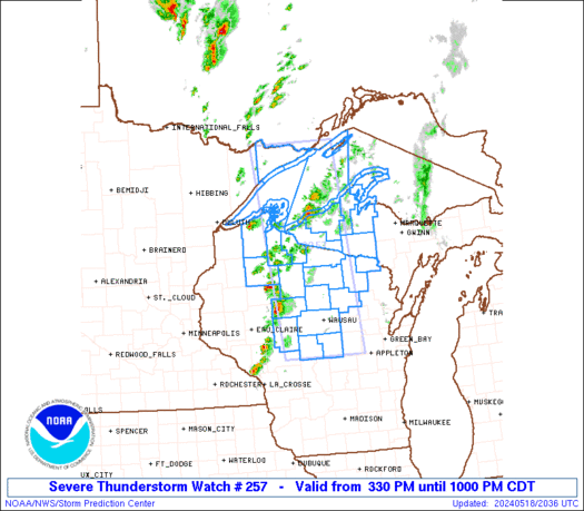
SPC Severe Thunderstorm Watch 257
WW 257 SEVERE TSTM MI MN WI LS 182030Z – 190300Z URGENT – IMMEDIATE BROADCAST REQUESTED Severe Thunderstorm Watch Number 257 NWS Storm Prediction Center Norman OK 330 PM CDT Sat May 18 2024 The NWS Storm Prediction Center has issued a * Severe Thunderstorm Watch for portions of Western Upper Michigan Minnesota Arrowhead Central …
Continue reading SPC Severe Thunderstorm Watch 257
SPC MD 827
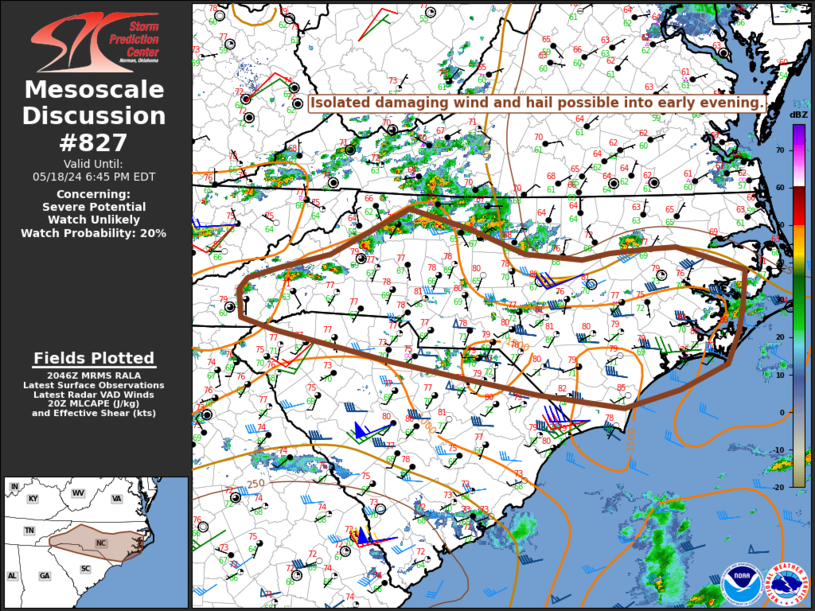
MD 0827 CONCERNING SEVERE POTENTIAL…WATCH UNLIKELY FOR NC INTO NORTHERN SC Mesoscale Discussion 0827 NWS Storm Prediction Center Norman OK 0349 PM CDT Sat May 18 2024 Areas affected…NC into northern SC Concerning…Severe potential…Watch unlikely Valid 182049Z – 182245Z Probability of Watch Issuance…20 percent SUMMARY…Isolated damaging winds and hail are possible into early evening. DISCUSSION…Convection …
Continue reading SPC MD 827
SPC MD 826
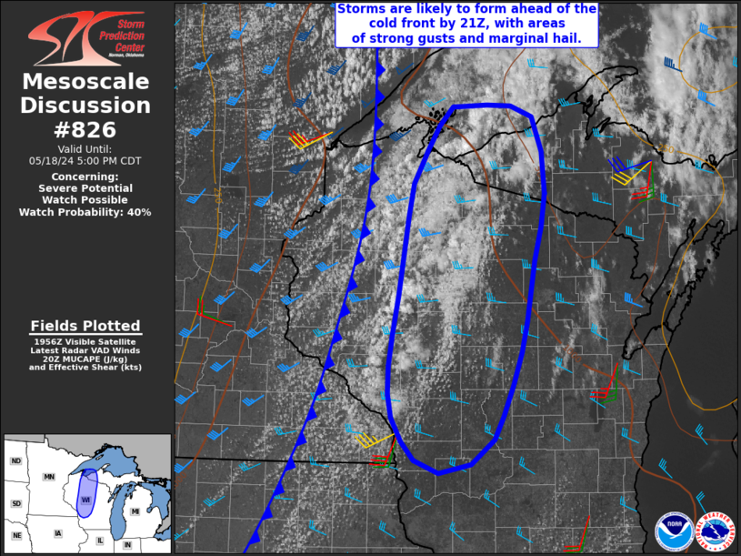
MD 0826 CONCERNING SEVERE POTENTIAL…WATCH POSSIBLE FOR PARTS OF CENTRAL AND NORTHERN WISCONSIN INTO WESTERN UPPER MICHIGAN Mesoscale Discussion 0826 NWS Storm Prediction Center Norman OK 0303 PM CDT Sat May 18 2024 Areas affected…parts of central and northern Wisconsin into western Upper Michigan Concerning…Severe potential…Watch possible Valid 182003Z – 182200Z Probability of Watch Issuance…40 …
Continue reading SPC MD 826
SPC MD 825
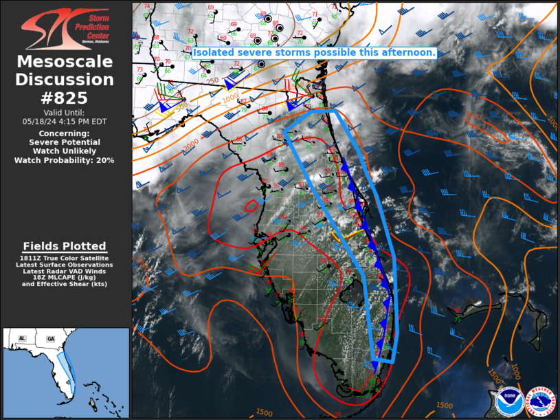
MD 0825 CONCERNING SEVERE POTENTIAL…WATCH UNLIKELY FOR THE EASTERN FL PENINSULA Mesoscale Discussion 0825 NWS Storm Prediction Center Norman OK 0116 PM CDT Sat May 18 2024 Areas affected…the eastern FL Peninsula Concerning…Severe potential…Watch unlikely Valid 181816Z – 182015Z Probability of Watch Issuance…20 percent SUMMARY…Isolated severe storms are possible this afternoon. DISCUSSION…A very warm and …
Continue reading SPC MD 825
SPC MD 824
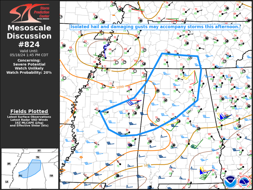
MD 0824 CONCERNING SEVERE POTENTIAL…WATCH UNLIKELY FOR NORTHEAST MS INTO NORTHERN AL AND SOUTHERN MIDDLE TN Mesoscale Discussion 0824 NWS Storm Prediction Center Norman OK 1144 AM CDT Sat May 18 2024 Areas affected…Northeast MS into northern AL and southern middle TN Concerning…Severe potential…Watch unlikely Valid 181644Z – 181845Z Probability of Watch Issuance…20 percent SUMMARY…Isolated …
Continue reading SPC MD 824