
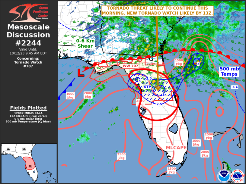
MD 2244 CONCERNING SEVERE POTENTIAL…WATCH UNLIKELY FOR THE COASTAL FLORIDA PANHANDLE Mesoscale Discussion 2244 NWS Storm Prediction Center Norman OK 0114 AM CST Tue Dec 02 2025 Areas affected…the coastal Florida Panhandle Concerning…Severe potential…Watch unlikely Valid 020714Z – 021115Z Probability of Watch Issuance…20 percent SUMMARY…Mini-supercells may eventually move ashore, affecting primarily coastal counties of the …
Continue reading SPC MD 2244
Category:Weather
SPC MD 2243
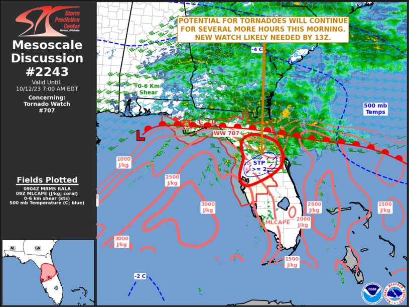
MD 2243 CONCERNING HEAVY SNOW FOR WESTERN/NORTHERN KENTUCKY AND ADJACENT PORTIONS OF THE OHIO VALLEY Mesoscale Discussion 2243 NWS Storm Prediction Center Norman OK 0910 PM CST Mon Dec 01 2025 Areas affected…western/northern Kentucky and adjacent portions of the Ohio Valley Concerning…Heavy snow Valid 020310Z – 020915Z SUMMARY…A narrow developing corridor of heavy snow rates …
Continue reading SPC MD 2243
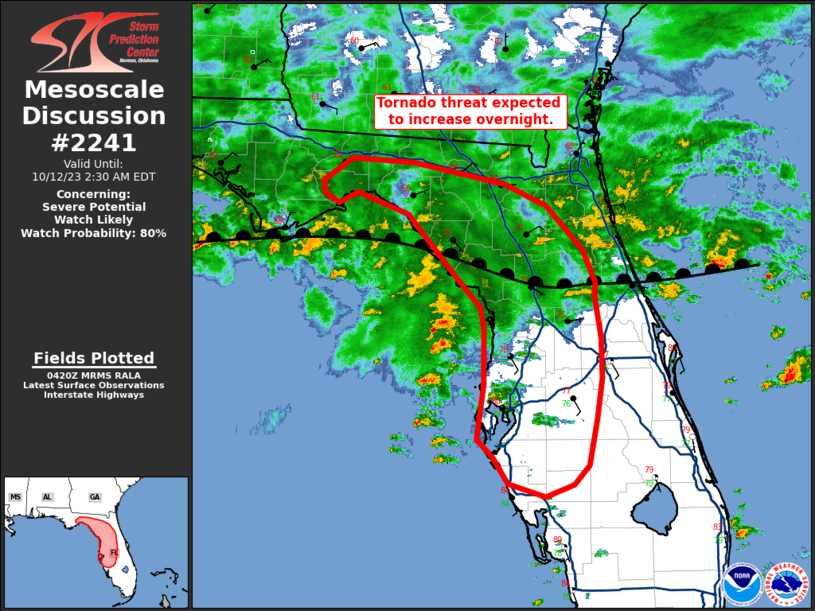
SPC MD 2242

MD 2242 CONCERNING WINTER MIXED PRECIPITATION FOR NORTHEAST OK…WESTERN/CENTRAL AR…FAR SOUTHWEST MO Mesoscale Discussion 2242 NWS Storm Prediction Center Norman OK 0637 AM CST Mon Dec 01 2025 Areas affected…Northeast OK…western/central AR…far southwest MO Concerning…Winter mixed precipitation Valid 011237Z – 011700Z SUMMARY…Freezing rain may increase across parts of central Arkansas this morning, while light mixed …
Continue reading SPC MD 2242
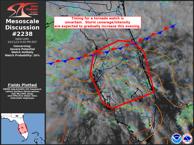
SPC MD 2241
MD 2241 CONCERNING SEVERE POTENTIAL…WATCH UNLIKELY FOR CENTRAL TEXAS TO THE TEXAS COASTAL PLAIN Mesoscale Discussion 2241 NWS Storm Prediction Center Norman OK 0317 PM CST Sat Nov 29 2025 Areas affected…Central Texas to the Texas Coastal Plain Concerning…Severe potential…Watch unlikely Valid 292117Z – 292315Z Probability of Watch Issuance…5 percent SUMMARY…Thunderstorm development is underway across …
Continue reading SPC MD 2241
SPC MD 2240

MD 2240 CONCERNING HEAVY SNOW FOR PARTS OF THE MIDWEST Mesoscale Discussion 2240 NWS Storm Prediction Center Norman OK 0216 PM CST Sat Nov 29 2025 Areas affected…parts of the Midwest Concerning…Heavy snow Valid 292016Z – 300015Z SUMMARY…Bursts of moderate to heavy snow are most likely to evolve east/northeast from central Illinois across parts of …
Continue reading SPC MD 2240
SPC MD 2239

MD 2239 CONCERNING HEAVY SNOW FOR PARTS OF IL…SOUTHEAST IA…AND FAR NORTHEAST MO Mesoscale Discussion 2239 NWS Storm Prediction Center Norman OK 1042 AM CST Sat Nov 29 2025 Areas affected…parts of IL…southeast IA…and far northeast MO Concerning…Heavy snow Valid 291642Z – 292145Z SUMMARY…Primary bands of moderate to sporadic heavy snow should pivot from south-central …
Continue reading SPC MD 2239
SPC MD 2238
MD 2238 CONCERNING HEAVY SNOW FOR EAST-CENTRAL/SOUTHEAST NE INTO SOUTHWEST/CENTRAL IA Mesoscale Discussion 2238 NWS Storm Prediction Center Norman OK 0449 AM CST Sat Nov 29 2025 Areas affected…East-central/southeast NE into southwest/central IA Concerning…Heavy snow Valid 291049Z – 291615Z SUMMARY…Snow rates may approach or exceed 1 inch per hour at times this morning. DISCUSSION…A long-duration …
Continue reading SPC MD 2238
SPC MD 2237
MD 2237 CONCERNING HEAVY SNOW FOR NORTHEAST/EAST-CENTRAL MO…SOUTHEAST IA…WESTERN IL Mesoscale Discussion 2237 NWS Storm Prediction Center Norman OK 0318 AM CST Sat Nov 29 2025 Areas affected…Northeast/east-central MO…southeast IA…western IL Concerning…Heavy snow Valid 290918Z – 291315Z SUMMARY…Moderate to locally heavy snow rates are possible early this morning. DISCUSSION…A large precipitation shield is spreading across …
Continue reading SPC MD 2237
SPC MD 2236

MD 2236 CONCERNING HEAVY SNOW FOR NORTHERN LOWER MICHIGAN Mesoscale Discussion 2236 NWS Storm Prediction Center Norman OK 1100 AM CST Thu Nov 27 2025 Areas affected…Northern Lower Michigan Concerning…Heavy snow Valid 271700Z – 272200Z SUMMARY…Snowfall rates of 1-2 inch per hour remain possible through mid/late afternoon. DISCUSSION…A dominant snow band off of Lake Michigan, …
Continue reading SPC MD 2236
SPC MD 2235

MD 2235 CONCERNING HEAVY SNOW FOR PARTS OF CENTRAL UPPER MI INTO NORTHERN LOWER MI Mesoscale Discussion 2235 NWS Storm Prediction Center Norman OK 0530 AM CST Thu Nov 27 2025 Areas affected…Parts of central Upper MI into northern Lower MI Concerning…Heavy snow Valid 271130Z – 271630Z SUMMARY…Heavy lake-effect snow bands will continue through the …
Continue reading SPC MD 2235