

WW 647 SEVERE TSTM NE SD 252215Z – 260500Z URGENT – IMMEDIATE BROADCAST REQUESTED Severe Thunderstorm Watch Number 647 NWS Storm Prediction Center Norman OK 515 PM CDT Sun Aug 25 2024 The NWS Storm Prediction Center has issued a * Severe Thunderstorm Watch for portions of North-central Nebraska Southeast and East-central South Dakota * …
Continue reading SPC Severe Thunderstorm Watch 647
Category:Weather
SPC Severe Thunderstorm Watch 646

WW 646 SEVERE TSTM CO UT WY 251920Z – 260200Z URGENT – IMMEDIATE BROADCAST REQUESTED Severe Thunderstorm Watch Number 646 NWS Storm Prediction Center Norman OK 120 PM MDT Sun Aug 25 2024 The NWS Storm Prediction Center has issued a * Severe Thunderstorm Watch for portions of Western Colorado Eastern Utah Southern Wyoming * …
Continue reading SPC Severe Thunderstorm Watch 646
SPC MD 1989
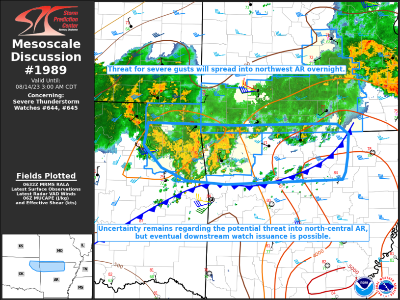
MD 1989 CONCERNING SEVERE THUNDERSTORM WATCH 646… FOR PORTIONS OF EASTERN UTAH INTO SOUTHERN WYOMING AND WESTERN COLORADO Mesoscale Discussion 1989 NWS Storm Prediction Center Norman OK 0457 PM CDT Sun Aug 25 2024 Areas affected…portions of eastern Utah into southern Wyoming and western Colorado Concerning…Severe Thunderstorm Watch 646… Valid 252157Z – 252330Z The severe …
Continue reading SPC MD 1989
SPC MD 1988

MD 1988 CONCERNING SEVERE POTENTIAL…WATCH POSSIBLE FOR FAR NORTH-CENTRAL NEBRASKA AND SOUTH-CENTRAL SOUTH DAKOTA Mesoscale Discussion 1988 NWS Storm Prediction Center Norman OK 0315 PM CDT Sun Aug 25 2024 Areas affected…Far north-central Nebraska and south-central South Dakota Concerning…Severe potential…Watch possible Valid 252015Z – 252245Z Probability of Watch Issuance…40 percent SUMMARY…Though isolated, a supercell or …
Continue reading SPC MD 1988
SPC MD 1987

MD 1987 CONCERNING SEVERE POTENTIAL…WATCH POSSIBLE FOR PARTS OF EASTERN UTAH…ADJACENT NORTHWESTERN COLORADO AND SOUTHWESTERN WYOMING Mesoscale Discussion 1987 NWS Storm Prediction Center Norman OK 1127 AM CDT Sun Aug 25 2024 Areas affected…parts of eastern Utah…adjacent northwestern Colorado and southwestern Wyoming Concerning…Severe potential…Watch possible Valid 251627Z – 251830Z Probability of Watch Issuance…40 percent SUMMARY…Intensifying …
Continue reading SPC MD 1987
SPC MD 1986

MD 1986 CONCERNING SEVERE POTENTIAL…WATCH UNLIKELY FOR NORTHEAST MONTANA AND EXTREME NORTHWEST NORTH DAKOTA Mesoscale Discussion 1986 NWS Storm Prediction Center Norman OK 1130 PM CDT Sat Aug 24 2024 Areas affected…Northeast Montana and extreme northwest North Dakota Concerning…Severe potential…Watch unlikely Valid 250430Z – 250630Z Probability of Watch Issuance…20 percent SUMMARY…Gusty winds and marginally severe …
Continue reading SPC MD 1986
SPC MD 1985

MD 1985 CONCERNING SEVERE POTENTIAL…WATCH UNLIKELY FOR PARTS OF NORTHEASTERN MONTANA Mesoscale Discussion 1985 NWS Storm Prediction Center Norman OK 0400 PM CDT Sat Aug 24 2024 Areas affected…parts of northeastern Montana Concerning…Severe potential…Watch unlikely Valid 242100Z – 242330Z Probability of Watch Issuance…20 percent SUMMARY…Thunderstorm activity may begin to initiate, with the evolution of an …
Continue reading SPC MD 1985
SPC MD 1984
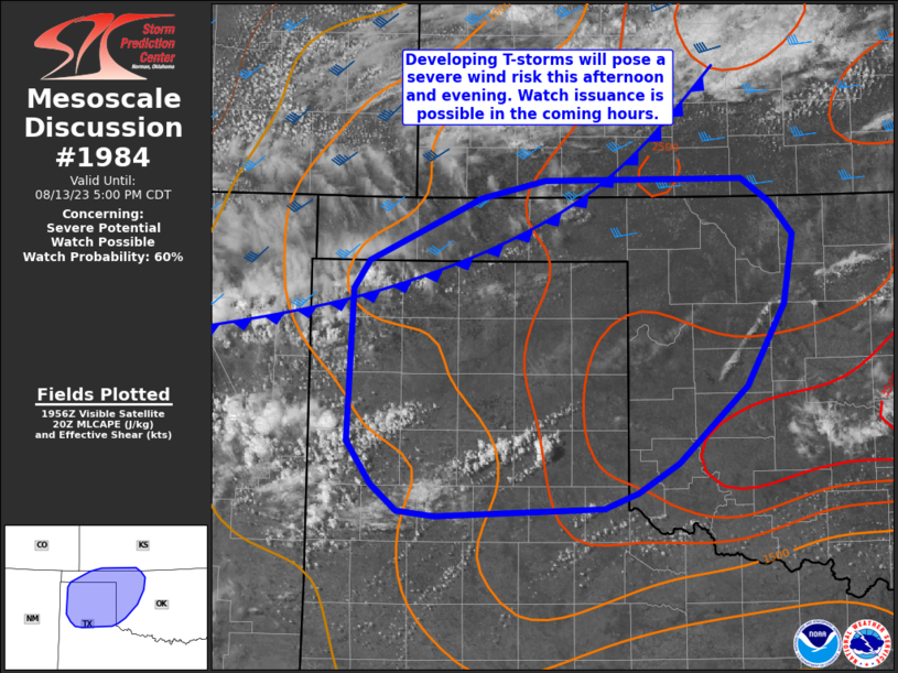
MD 1984 CONCERNING SEVERE POTENTIAL…WATCH UNLIKELY FOR NORTHWEST NEW MEXICO INTO SOUTH-CENTRAL COLORADO Mesoscale Discussion 1984 NWS Storm Prediction Center Norman OK 0349 PM CDT Sat Aug 24 2024 Areas affected…Northwest New Mexico into south-central Colorado Concerning…Severe potential…Watch unlikely Valid 242049Z – 242245Z Probability of Watch Issuance…5 percent SUMMARY…Strong to severe winds and small to …
Continue reading SPC MD 1984
SPC Severe Thunderstorm Watch 645

WW 645 SEVERE TSTM MT 232055Z – 240300Z URGENT – IMMEDIATE BROADCAST REQUESTED Severe Thunderstorm Watch Number 645 NWS Storm Prediction Center Norman OK 255 PM MDT Fri Aug 23 2024 The NWS Storm Prediction Center has issued a * Severe Thunderstorm Watch for portions of Western and Central Montana * Effective this Friday afternoon …
Continue reading SPC Severe Thunderstorm Watch 645
SPC Severe Thunderstorm Watch 645 Status Reports
WW 0645 Status Updates STATUS REPORT ON WW 645 SEVERE WEATHER THREAT CONTINUES RIGHT OF A LINE FROM 15 NNW LVM TO 25 SSW GTF TO 45 SSW CTB TO 40 SE GPI TO 35 SSW GPI. ..SPC..08/24/24 ATTN…WFO…TFX…MSO… STATUS REPORT FOR WS 645 SEVERE WEATHER THREAT CONTINUES FOR THE FOLLOWING AREAS MTC005-013-015-027-029-035-041-045-051-053-059-073-099-101- 240140- MT …
Continue reading SPC Severe Thunderstorm Watch 645 Status Reports