
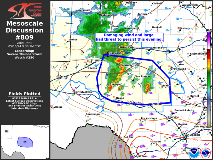
MD 0809 CONCERNING SEVERE THUNDERSTORM WATCH 250… FOR THE PERMIAN BASIN INTO CENTRAL TEXAS Mesoscale Discussion 0809 NWS Storm Prediction Center Norman OK 0754 PM CDT Thu May 16 2024 Areas affected…the Permian Basin into central Texas Concerning…Severe Thunderstorm Watch 250… Valid 170054Z – 170230Z The severe weather threat for Severe Thunderstorm Watch 250 continues. …
Continue reading SPC MD 809
Month:May 2024
SPC Tornado Watch 251
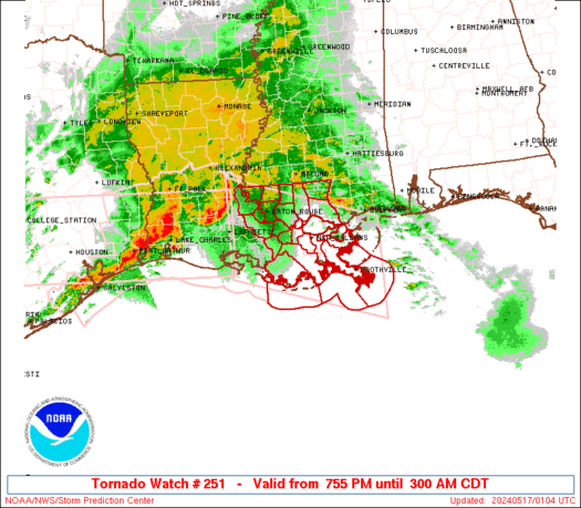
WW 251 TORNADO LA CW 170055Z – 170800Z URGENT – IMMEDIATE BROADCAST REQUESTED Tornado Watch Number 251 NWS Storm Prediction Center Norman OK 755 PM CDT Thu May 16 2024 The NWS Storm Prediction Center has issued a * Tornado Watch for portions of Southeast Louisiana Coastal Waters * Effective this Thursday night and Friday …
Continue reading SPC Tornado Watch 251
SPC MD 807
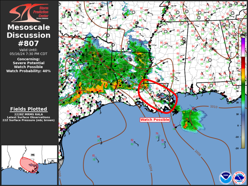
MD 0807 CONCERNING SEVERE POTENTIAL…WATCH POSSIBLE FOR LOWER MISSISSIPPI VALLEY Mesoscale Discussion 0807 NWS Storm Prediction Center Norman OK 0531 PM CDT Thu May 16 2024 Areas affected…Lower Mississippi Valley Concerning…Severe potential…Watch possible Valid 162231Z – 170030Z Probability of Watch Issuance…40 percent SUMMARY…Severe threat is expected to gradually increase across the lower MS Valley this …
Continue reading SPC MD 807
SPC Tornado Watch 249
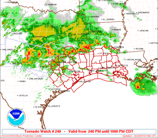
WW 249 TORNADO LA TX CW 161940Z – 170300Z URGENT – IMMEDIATE BROADCAST REQUESTED Tornado Watch Number 249 NWS Storm Prediction Center Norman OK 240 PM CDT Thu May 16 2024 The NWS Storm Prediction Center has issued a * Tornado Watch for portions of Southwest Louisiana Southeast Texas Coastal Waters * Effective this Thursday …
Continue reading SPC Tornado Watch 249
SPC Severe Thunderstorm Watch 250
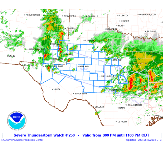
WW 250 SEVERE TSTM NM TX 162000Z – 170400Z URGENT – IMMEDIATE BROADCAST REQUESTED Severe Thunderstorm Watch Number 250 NWS Storm Prediction Center Norman OK 300 PM CDT Thu May 16 2024 The NWS Storm Prediction Center has issued a * Severe Thunderstorm Watch for portions of Southeast New Mexico West Texas into the Edwards …
Continue reading SPC Severe Thunderstorm Watch 250
Threads Gets Multi-Column TweetDeck-Like Web View
Threads is working on a new web view that features the option to pin customized columns, similar to the TweetDeck feature that used to be available on Twitter. Meta CEO Mark Zuckerberg shared an image of the new web option, which he said is currently being tested. The screenshot shows several custom columns, including a …
Continue reading Threads Gets Multi-Column TweetDeck-Like Web View
SPC MD 805
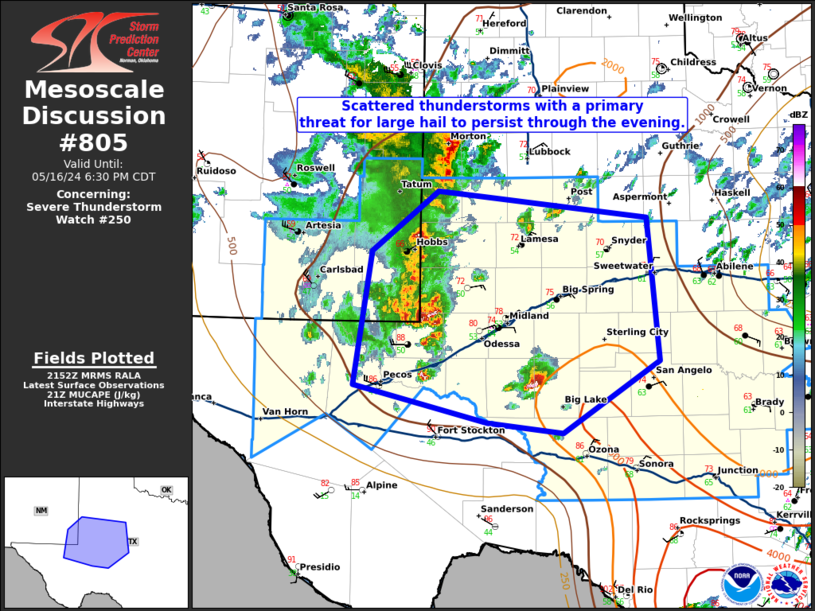
MD 0805 CONCERNING SEVERE THUNDERSTORM WATCH 250… FOR EASTERN NEW MEXICO INTO WEST TEXAS Mesoscale Discussion 0805 NWS Storm Prediction Center Norman OK 0455 PM CDT Thu May 16 2024 Areas affected…eastern New Mexico into West Texas Concerning…Severe Thunderstorm Watch 250… Valid 162155Z – 162330Z The severe weather threat for Severe Thunderstorm Watch 250 continues. …
Continue reading SPC MD 805
SPC MD 806
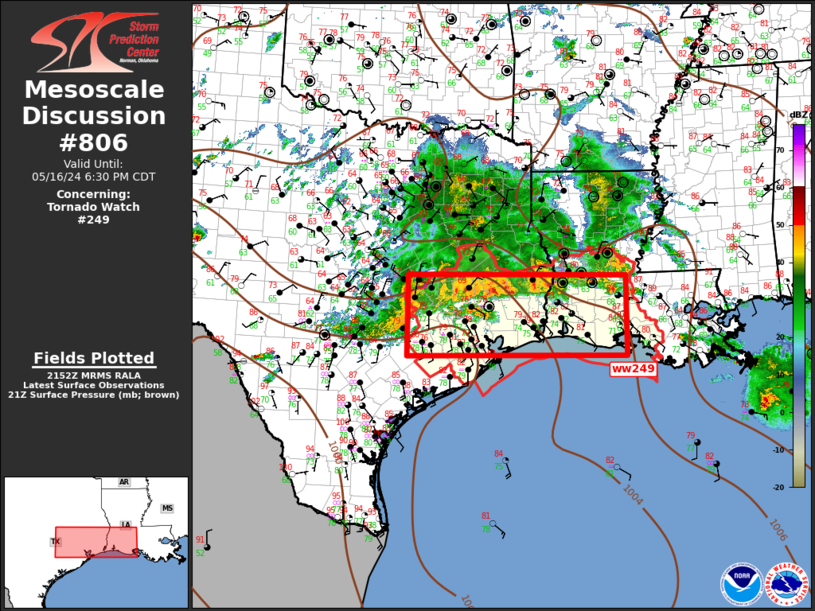
MD 0806 CONCERNING TORNADO WATCH 249… FOR SOUTHEAST TX…SOUTHERN LA Mesoscale Discussion 0806 NWS Storm Prediction Center Norman OK 0456 PM CDT Thu May 16 2024 Areas affected…Southeast TX…Southern LA Concerning…Tornado Watch 249… Valid 162156Z – 162330Z The severe weather threat for Tornado Watch 249 continues. SUMMARY…Severe threat will gradually spread southeast across ww249 this …
Continue reading SPC MD 806
iMessage Down for Some Users
The iMessage service that Apple users to send messages to one another appears to be down for some users, and messages are failing to go out or are taking an extra long time to send. There are numerous reports about the issue on social networks and a spike of outage reports on Down Detector, but …
Continue reading iMessage Down for Some Users
SPC MD 804
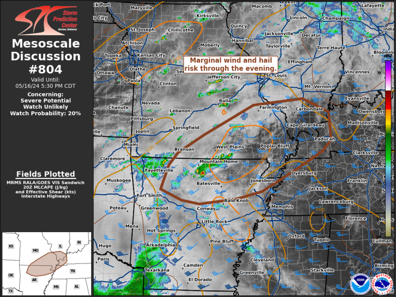
MD 0804 CONCERNING SEVERE POTENTIAL…WATCH UNLIKELY FOR NORTHERN ARKANSAS…SOUTH EASTERN MISSOURI…SOUTHERN ILLINOIS…FAR WESTERN KENTUCKY Mesoscale Discussion 0804 NWS Storm Prediction Center Norman OK 0325 PM CDT Thu May 16 2024 Areas affected…northern Arkansas…south eastern Missouri…southern Illinois…far western Kentucky Concerning…Severe potential…Watch unlikely Valid 162025Z – 162230Z Probability of Watch Issuance…20 percent SUMMARY…Marginal wind and hail risk …
Continue reading SPC MD 804