

MD 2136 CONCERNING SEVERE POTENTIAL…WATCH POSSIBLE FOR NORTHEAST COLORADO…SOUTHEAST WYOMING…AND THE NEBRASKA PANHANDLE Mesoscale Discussion 2136 NWS Storm Prediction Center Norman OK 0355 PM CDT Sat Oct 04 2025 Areas affected…northeast Colorado…southeast Wyoming…and the Nebraska Panhandle Concerning…Severe potential…Watch possible Valid 042055Z – 042300Z Probability of Watch Issuance…40 percent SUMMARY…Thunderstorms will increase in coverage and intensity …
Continue reading SPC MD 2136
Category:Weather
SPC MD 2135
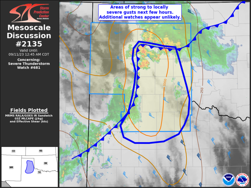
MD 2135 CONCERNING SEVERE POTENTIAL…WATCH UNLIKELY FOR SOUTHERN NEW MEXICO INTO FAR WEST TEXAS Mesoscale Discussion 2135 NWS Storm Prediction Center Norman OK 0309 PM CDT Sun Sep 28 2025 Areas affected…southern New Mexico into Far West Texas Concerning…Severe potential…Watch unlikely Valid 282009Z – 282245Z Probability of Watch Issuance…20 percent SUMMARY…Scattered storms, some with hail, …
Continue reading SPC MD 2135
SPC MD 2134
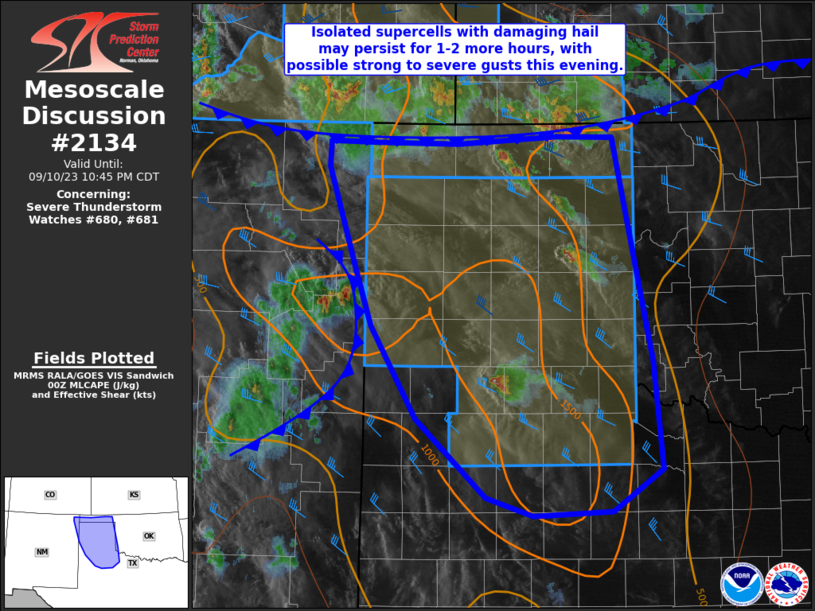
MD 2134 CONCERNING SEVERE THUNDERSTORM WATCH 621… FOR SOUTH-CENTRAL ARIZONA Mesoscale Discussion 2134 NWS Storm Prediction Center Norman OK 0735 PM CDT Fri Sep 26 2025 Areas affected…South-central Arizona Concerning…Severe Thunderstorm Watch 621… Valid 270035Z – 270230Z The severe weather threat for Severe Thunderstorm Watch 621 continues. SUMMARY…Isolated strong to severe thunderstorms will remain possible …
Continue reading SPC MD 2134
SPC Severe Thunderstorm Watch 621 Status Reports

WW 0621 Status Updates STATUS REPORT ON WW 621 SEVERE WEATHER THREAT CONTINUES RIGHT OF A LINE FROM 40 N GBN TO 25 WSW SOW TO 25 S SOW TO 35 SSE FHU. FOR ADDITIONAL INFORMATION SEE MESOSCALE DISCUSSION 2133 ..MOORE..09/26/25 ATTN…WFO…TWC…PSR…FGZ… STATUS REPORT FOR WS 621 SEVERE WEATHER THREAT CONTINUES FOR THE FOLLOWING AREAS …
Continue reading SPC Severe Thunderstorm Watch 621 Status Reports
SPC Severe Thunderstorm Watch 621
WW 621 SEVERE TSTM AZ 261900Z – 270200Z URGENT – IMMEDIATE BROADCAST REQUESTED Severe Thunderstorm Watch Number 621…CORRECTED NWS Storm Prediction Center Norman OK 1235 PM MST Fri Sep 26 2025 CORRECTED FOR TIMEZONE The NWS Storm Prediction Center has issued a * Severe Thunderstorm Watch for portions of Central and Southern Arizona * Effective …
Continue reading SPC Severe Thunderstorm Watch 621
SPC MD 2133
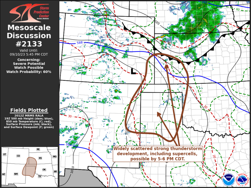
MD 2133 CONCERNING SEVERE THUNDERSTORM WATCH 621… FOR SOUTH-CENTRAL ARIZONA Mesoscale Discussion 2133 NWS Storm Prediction Center Norman OK 0500 PM CDT Fri Sep 26 2025 Areas affected…South-central Arizona Concerning…Severe Thunderstorm Watch 621… Valid 262200Z – 270000Z The severe weather threat for Severe Thunderstorm Watch 621 continues. SUMMARY…Thunderstorms will continue to develop along an outflow …
Continue reading SPC MD 2133
SPC MD 2132
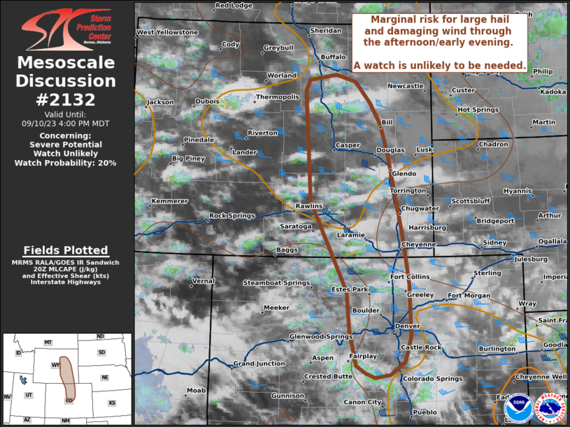
MD 2132 CONCERNING SEVERE THUNDERSTORM WATCH 621… FOR PORTIONS OF CENTRAL AND SOUTHERN ARIZONA Mesoscale Discussion 2132 NWS Storm Prediction Center Norman OK 0334 PM CDT Fri Sep 26 2025 Areas affected…portions of central and southern Arizona Concerning…Severe Thunderstorm Watch 621… Valid 262034Z – 262200Z The severe weather threat for Severe Thunderstorm Watch 621 continues. …
Continue reading SPC MD 2132
SPC MD 2130
MD 2130 CONCERNING SEVERE POTENTIAL…WATCH UNLIKELY FOR PORTIONS OF CENTRAL/SOUTHERN ARIZONA Mesoscale Discussion 2130 NWS Storm Prediction Center Norman OK 1146 AM CDT Fri Sep 26 2025 Areas affected…portions of central/southern Arizona Concerning…Severe potential…Watch unlikely Valid 261646Z – 261845Z Probability of Watch Issuance…20 percent SUMMARY…A few instances of severe hail/wind will be possible through the …
Continue reading SPC MD 2130
SPC MD 2129

MD 2129 CONCERNING SEVERE POTENTIAL…WATCH UNLIKELY FOR PORTIONS OF SOUTHERN/CENTRAL ARIZONA Mesoscale Discussion 2129 NWS Storm Prediction Center Norman OK 0225 PM CDT Thu Sep 25 2025 Areas affected…Portions of southern/central Arizona Concerning…Severe potential…Watch unlikely Valid 251925Z – 252130Z Probability of Watch Issuance…20 percent SUMMARY…Isolated large hail and severe gusts are possible this afternoon. A …
Continue reading SPC MD 2129
SPC MD 2128
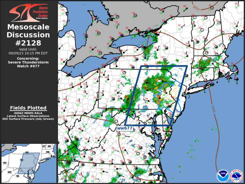
MD 2128 CONCERNING SEVERE POTENTIAL…WATCH UNLIKELY FOR PORTIONS OF NORTHERN MD…EASTERN PA…FAR SOUTHERN NY…NJ…AND NORTHERN DE Mesoscale Discussion 2128 NWS Storm Prediction Center Norman OK 0222 PM CDT Thu Sep 25 2025 Areas affected…portions of northern MD…eastern PA…far southern NY…NJ…and northern DE Concerning…Severe potential…Watch unlikely Valid 251922Z – 252115Z Probability of Watch Issuance…20 percent SUMMARY…Sporadic …
Continue reading SPC MD 2128