
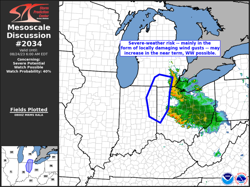
MD 2034 CONCERNING SEVERE POTENTIAL…WATCH UNLIKELY FOR PORTIONS OF SOUTHEASTERN SOUTH DAKOTA INTO FAR SOUTHWESTERN MINNESOTA AND EXTREME NORTHWESTERN IOWA Mesoscale Discussion 2034 NWS Storm Prediction Center Norman OK 0456 PM CDT Thu Sep 04 2025 Areas affected…portions of southeastern South Dakota into far southwestern Minnesota and extreme northwestern Iowa Concerning…Severe potential…Watch unlikely Valid 042156Z …
Continue reading SPC MD 2034
Category:Weather
SPC MD 2033
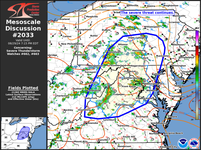
MD 2033 CONCERNING SEVERE POTENTIAL…WATCH UNLIKELY FOR PORTIONS OF EASTERN MARYLAND…EASTERN VIRGINIA…AND NORTHERN NORTH CAROLINA Mesoscale Discussion 2033 NWS Storm Prediction Center Norman OK 0439 PM CDT Thu Sep 04 2025 Areas affected…portions of eastern Maryland…eastern Virginia…and northern North Carolina Concerning…Severe potential…Watch unlikely Valid 042139Z – 042315Z Probability of Watch Issuance…5 percent SUMMARY…A few damaging …
Continue reading SPC MD 2033
SPC MD 2032
MD 2032 CONCERNING SEVERE POTENTIAL…WATCH UNLIKELY FOR PARTS OF MIDDLE/EASTERN TENNESSEE Mesoscale Discussion 2032 NWS Storm Prediction Center Norman OK 0119 PM CDT Thu Sep 04 2025 Areas affected…parts of middle/eastern Tennessee Concerning…Severe potential…Watch unlikely Valid 041819Z – 042045Z Probability of Watch Issuance…20 percent SUMMARY…Occasional intensification of thunderstorms posing a risk for severe hail and …
Continue reading SPC MD 2032
SPC MD 2031
MD 2031 CONCERNING SEVERE POTENTIAL…WATCH UNLIKELY FOR PARTS OF SOUTHWESTERN THROUGH NORTH CENTRAL VIRGINIA…NORTHWESTERN NORTH CAROLINA Mesoscale Discussion 2031 NWS Storm Prediction Center Norman OK 1241 PM CDT Thu Sep 04 2025 Areas affected…parts of southwestern through north central Virginia…northwestern North Carolina Concerning…Severe potential…Watch unlikely Valid 041741Z – 041945Z Probability of Watch Issuance…20 percent SUMMARY…Developing …
Continue reading SPC MD 2031
SPC MD 2030
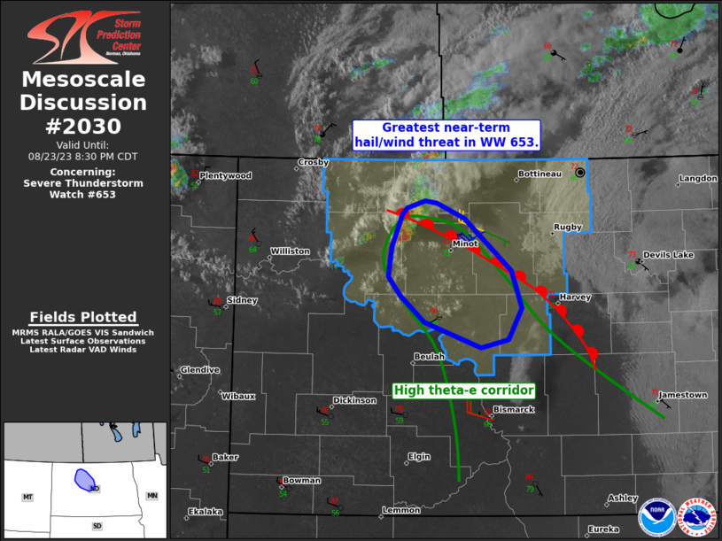
MD 2030 CONCERNING SEVERE POTENTIAL…WATCH UNLIKELY FOR WESTERN INTO CENTRAL NEW YORK STATE…ADJACENT NORTHWESTERN INTO NORTH CENTRAL PENNSYLVANIA Mesoscale Discussion 2030 NWS Storm Prediction Center Norman OK 0944 AM CDT Thu Sep 04 2025 Areas affected…western into central New York State…adjacent northwestern into north central Pennsylvania Concerning…Severe potential…Watch unlikely Valid 041444Z – 041645Z Probability of …
Continue reading SPC MD 2030
SPC Severe Thunderstorm Watch 605 Status Reports

WW 0605 Status Updates STATUS REPORT ON WW 605 SEVERE WEATHER THREAT CONTINUES RIGHT OF A LINE FROM 20 SSE P28 TO 50 NNW BVO TO 30 WNW SGF. ..THORNTON..09/04/25 ATTN…WFO…ICT…TOP…DDC…SGF…EAX… STATUS REPORT FOR WS 605 SEVERE WEATHER THREAT CONTINUES FOR THE FOLLOWING AREAS KSC019-035-099-125-040340- KS . KANSAS COUNTIES INCLUDED ARE CHAUTAUQUA COWLEY LABETTE MONTGOMERY …
Continue reading SPC Severe Thunderstorm Watch 605 Status Reports
SPC MD 2029
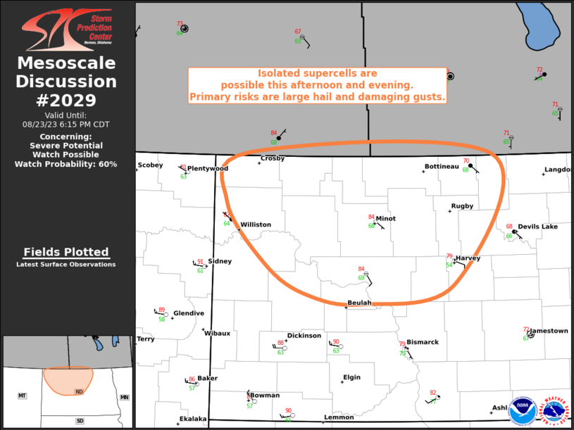
MD 2029 CONCERNING SEVERE THUNDERSTORM WATCH 605… FOR PORTIONS OF SOUTHEASTERN KANSAS Mesoscale Discussion 2029 NWS Storm Prediction Center Norman OK 0720 PM CDT Wed Sep 03 2025 Areas affected…portions of southeastern Kansas Concerning…Severe Thunderstorm Watch 605… Valid 040020Z – 040115Z The severe weather threat for Severe Thunderstorm Watch 605 continues. SUMMARY…Supercell capable of large …
Continue reading SPC MD 2029
SPC Severe Thunderstorm Watch 605
WW 605 SEVERE TSTM KS MO 032220Z – 040400Z URGENT – IMMEDIATE BROADCAST REQUESTED Severe Thunderstorm Watch Number 605 NWS Storm Prediction Center Norman OK 520 PM CDT Wed Sep 3 2025 The NWS Storm Prediction Center has issued a * Severe Thunderstorm Watch for portions of Central and Eastern Kansas Western Missouri * Effective …
Continue reading SPC Severe Thunderstorm Watch 605
SPC MD 2028
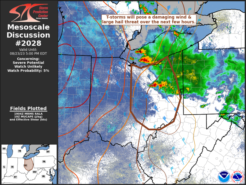
MD 2028 CONCERNING SEVERE POTENTIAL…WATCH LIKELY FOR PORTIONS OF CENTRAL AND EASTERN KANSAS INTO WESTERN MISSOURI Mesoscale Discussion 2028 NWS Storm Prediction Center Norman OK 0443 PM CDT Wed Sep 03 2025 Areas affected…portions of central and eastern Kansas into western Missouri Concerning…Severe potential…Watch likely Valid 032143Z – 032245Z Probability of Watch Issuance…80 percent SUMMARY…Isolated …
Continue reading SPC MD 2028
SPC MD 2027
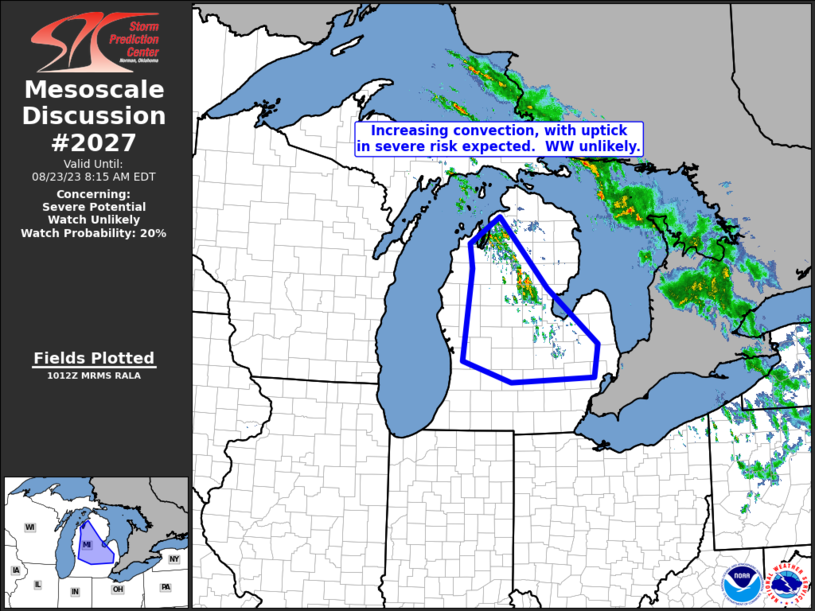
MD 2027 CONCERNING SEVERE POTENTIAL…WATCH UNLIKELY FOR EASTERN SD INTO SOUTHERN/CENTRAL MN AND FAR NORTHWEST WI Mesoscale Discussion 2027 NWS Storm Prediction Center Norman OK 0316 PM CDT Tue Sep 02 2025 Areas affected…Eastern SD into southern/central MN and far northwest WI Concerning…Severe potential…Watch unlikely Valid 022016Z – 022215Z Probability of Watch Issuance…20 percent SUMMARY…Isolated …
Continue reading SPC MD 2027